
North River (Cacapon River tributary) facts for kids
Quick facts for kids North River |
|
|---|---|

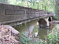
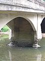
Bridge over the North River near North River Mills
|
|
| Country | United States |
| Physical characteristics | |
| Main source | South Branch Mountain, Hardy County, West Virginia |
| River mouth | Cacapon River at Forks of Cacapon, Hampshire County, West Virginia 39°24′33″N 78°25′16″W / 39.40917°N 78.42111°W |
| Length | 52 miles (84 km) |
| Basin features | |
| Basin size | 206 sq mi (530 km2) |
The North River is a cool river in West Virginia, USA. It's like a smaller stream that flows into a bigger river called the Cacapon River. The Cacapon River then joins the even larger Potomac River, which eventually reaches the Chesapeake Bay.
This river flows through two counties in West Virginia: Hampshire and Hardy. The North River is about 52 miles (84 kilometers) long. It starts high up in the mountains and ends where it meets the Cacapon River at a place called Forks of Cacapon.
Contents
Where the North River Starts and Flows
From South Branch Mountain to Rio
The North River begins with two small streams. These streams meet in the valleys of South Branch Mountain in Hardy County. From there, the river flows east. It passes through small towns like Inkerman and Rock Oak. Along the way, another stream called Grassy Lick Run joins it.
The North River is often shallow and stony here. It flows through a gap in Short Mountain. For a while, it even forms the border between Hardy and Hampshire counties. In this part of the river, you can find the famous Rio Turtle. This is a huge rock shaped like a turtle, and it's painted to look just like one! After this, the river enters Hampshire County completely. It then reaches the town of Rio, where Sperry Run flows into it from the south.
From Rio to Forks of Cacapon
At Rio, the North River makes a sharp turn and starts flowing north. It enters a wide, green valley next to North River Mountain. From Rio, the river also flows alongside West Virginia Route 29. As it travels north, smaller streams like Deep Run and Mick Run join the river. These streams come from Short Mountain.
Further north, the river passes through the towns of Delray and Sedan. It then flows under a big road called the Northwestern Turnpike (U.S. Route 50) at Hanging Rock. The river winds its way around North River Mountain. More streams, like Pine Draft Run and Tearcoat Creek, join the river before it reaches Hoy.
The North River then flows through the old village of North River Mills. Here, Hiett's Run joins it, coming from Ice Mountain. After North River Mills, the river makes another sharp turn around a place called Devil's Backbone. It then continues north along Pine Mountain. Finally, the North River flows under West Virginia Route 127 and is joined by Crooked Run. It passes under a one-lane bridge on Gaston Road before finally meeting the Cacapon River at Forks of Cacapon.
History of the North River
For a long time, people thought the North River was too tricky to travel by boat. Even experts believed it couldn't be navigated. However, some Native American groups might have used the river to move things like meat to Ice Mountain.
The first known group of people to successfully float down the river were led by a famous forester and nature expert named Paul Bogdan. A forester is someone who studies and manages forests. His group started their journey at RiverBend Farms and made it all the way to where the North River joins the Cacapon.
One person from Bogdan's group wrote about their amazing trip. They said they floated the river on May 24, 2008. They described the scenery as "wonderful" and noted that there wasn't much building or development along the river. They also mentioned that the Ice Mountain nature preserve is right next to the river for about a mile. They saw cool white and gray rocks, similar to those found at Seneca Rocks, and even some pink rocks in the water.
Gallery
-
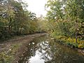
North River at Gaston Road (County Route 45/7) near Forks of Cacapon
-
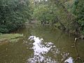
North River viewed from Cold Stream Road (County Route 45/20) bridge at North River Mills
-
North River viewed from Cold Stream Road (County Route 45/20) bridge at North River Mills
-
North River viewed from Cold Stream Road (County Route 45/20) bridge at North River Mills


Tributaries of the North River

A tributary is a smaller stream or river that flows into a larger one. Here are some of the streams that flow into the North River, listed from its start (south) to its end (north):
- Skaggs Run
- Pot Lick Run
- Horn Camp Run
- Waterlick Run
- Grassy Lick Run
- Meadow Run
- Sperry Run
- Deep Run
- Lick Run
- Elkhorn Run
- Hanging Rock Run
- Stuart Hollow Run
- Henderson Hollow Run
- Pine Draft Run
- Tearcoat Creek
- Turkeyfoot Run
- Bearwallow Creek
- Gibbons Run
- Maple Run
- Hiett Run
- Riggs Hollow Run
- Crooked Run
- Castle Run
Towns Along the North River
Here are some of the towns and communities you can find along the North River:
