Norwood, Pennsylvania facts for kids
Quick facts for kids
Norwood, Pennsylvania
|
|
|---|---|

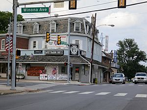
Corner of Winona and Chester Pike (Facing the Davis’ Trading Post)
|
|

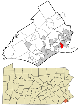
Location in Delaware County and the U.S. state of Pennsylvania.
|
|
| Country | United States |
| State | Pennsylvania |
| County | Delaware |
| Area | |
| • Total | 0.82 sq mi (2.11 km2) |
| • Land | 0.78 sq mi (2.01 km2) |
| • Water | 0.04 sq mi (0.10 km2) |
| Elevation | 82 ft (25 m) |
| Population
(2020)
|
|
| • Total | 5,943 |
| • Density | 7,638.82/sq mi (2,950.02/km2) |
| Time zone | UTC-5 (EST) |
| • Summer (DST) | UTC-4 (EDT) |
| ZIP code |
19074
|
| Area codes | 610 and 484 |
| FIPS code | 42-045-55664 |
| FIPS code | 42-55664 |
| GNIS feature ID | 1182691 |
Norwood is a small town, called a borough, in Delaware County, Pennsylvania, USA. In 2020, about 5,943 people lived there.
Contents
History of Norwood
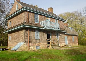
One important historical building in Norwood is the Morton Morton House. It was built around 1750. This house is special because it belonged to Morton Morton (1701–1781).
Morton Morton was the great-grandson of Marten Martenson. Marten Martenson was one of the first settlers in New Sweden in 1654. Morton Morton was also a cousin to John Morton. John Morton was one of the people who signed the Declaration of Independence.
The Morton Morton House was added to the National Register of Historic Places in 2000. This means it is a very important historical site.
Norwood's Geography
Norwood is located in the southeastern part of Delaware County. It is surrounded by several other towns. To the northeast is Glenolden. To the east is Folcroft. To the south is Tinicum Township. To the west is Prospect Park. Finally, to the west and north is Ridley Township.
Two creeks also border Norwood. The Darby Creek is to the south. The Muckinipattis Creek is to the east.
The United States Census Bureau says that Norwood covers a total area of about 2.1 square kilometers (0.82 square miles). Most of this area, about 2.0 square kilometers (0.78 square miles), is land. The rest, about 0.1 square kilometers (0.04 square miles), is water.
Population and People
| Historical population | |||
|---|---|---|---|
| Census | Pop. | %± | |
| 1880 | 194 | — | |
| 1900 | 1,286 | — | |
| 1910 | 1,668 | 29.7% | |
| 1920 | 2,353 | 41.1% | |
| 1930 | 3,878 | 64.8% | |
| 1940 | 3,921 | 1.1% | |
| 1950 | 5,246 | 33.8% | |
| 1960 | 6,729 | 28.3% | |
| 1970 | 7,229 | 7.4% | |
| 1980 | 6,647 | −8.1% | |
| 1990 | 6,162 | −7.3% | |
| 2000 | 5,985 | −2.9% | |
| 2010 | 5,890 | −1.6% | |
| 2020 | 5,943 | 0.9% | |
| Sources: | |||
In 2020, the population of Norwood was 5,943 people.
According to the 2010 Census, most people in Norwood were White (95.0%). There were also African American (1.5%), Asian (2.0%), and Native American (0.1%) residents. About 1.4% of the population was Hispanic or Latino.
In 2000, there were 5,985 people living in Norwood. There were 2,286 households, which are groups of people living together. About 33.2% of these households had children under 18. The average household had 2.62 people.
The median age in Norwood was 36 years old. This means half the people were younger than 36 and half were older.
Education in Norwood
Norwood is part of the Interboro School District. Young students attend Norwood School, which teaches grades K-8. Older students go to Interboro High School for grades 9–12. There is also a Kindergarten Academy in Prospect Park for the youngest students from Norwood.
For students who attend Catholic schools, there is St. James Regional Catholic School. This school is located in Ridley Park. It was formed in 2012 when St. Gabriel Catholic School merged with another school. St. Gabriel used to be located right in Norwood.
St. Gabriel School opened in 1960. Many students from Norwood, Folcroft, Glenolden, and Prospect Park attended it. In the past, St. Gabriel had over 1,000 students. However, the number of students went down over time.
Notable People from Norwood
Norwood has been home to some well-known individuals:
- Bill Foster – He was a famous basketball coach for Duke University.
- Grover C. Talbot – He served as a Pennsylvania State Representative for Delaware County. He was also the Speaker of the Pennsylvania House of Representatives from 1933 to 1934.
Transportation in Norwood
Norwood has several public roads. Most of these roads are maintained by the borough itself. A smaller portion is maintained by the Pennsylvania Department of Transportation (PennDOT).
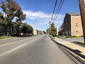
U.S. Route 13, also known as Chester Pike, is the main road that goes through Norwood. This road can take you northeast to Center City Philadelphia. It can also take you southwest to Chester.
Norwood also has a train station called Norwood station. This station is part of the SEPTA Regional Rail system. You can take a train from here to Center City Philadelphia or to Wilmington and Newark, Delaware. SEPTA also runs a bus, Route 114, which stops on Chester Pike in Norwood. This bus travels between the Darby Transportation Center and Wawa station.
See also
 In Spanish: Norwood (Pensilvania) para niños
 | Jessica Watkins |
 | Robert Henry Lawrence Jr. |
 | Mae Jemison |
 | Sian Proctor |
 | Guion Bluford |


