Oakdale, Minnesota facts for kids
Quick facts for kids
Oakdale
|
||
|---|---|---|
|
||

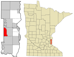
Location of the city of Oakdale
within Washington County, Minnesota |
||
| Country | United States | |
| State | Minnesota | |
| County | Washington | |
| Oakdale Township | 1848 | |
| Organized | May and November 1858 | |
| Incorporated | March 12, 1968 | |
| Area | ||
| • Total | 11.31 sq mi (29.29 km2) | |
| • Land | 10.96 sq mi (28.39 km2) | |
| • Water | 0.35 sq mi (0.90 km2) | |
| Elevation | 1,056 ft (322 m) | |
| Population
(2020)
|
||
| • Total | 28,303 | |
| • Estimate
(2022)
|
27,799 | |
| • Density | 2,582.39/sq mi (997.03/km2) | |
| Time zone | UTC-6 (Central) | |
| • Summer (DST) | UTC-5 (CDT) | |
| ZIP codes |
55042, 55128
|
|
| Area code(s) | 651 | |
| FIPS code | 27-47680 | |
| GNIS feature ID | 2395287 | |
Oakdale is a city in Washington County, Minnesota, United States. It is a suburb of Saint Paul and is located on the eastern side of the Twin Cities Metropolitan Area. In 2020, the city had a population of 28,303 people. This makes Oakdale the 36th largest city in Minnesota by population.
Oakdale is home to many residents who work at the nearby 3M headquarters. The city also has a strong connection to education. All students in Oakdale attend schools within the North St. Paul–Maplewood–Oakdale school district (ISD 622).
Students in Oakdale go to one of two high schools. Tartan Senior High School is located right in Oakdale and serves the southern part of the city. Students living in the northern part of Oakdale attend North High School in North St. Paul.
Contents
History of Oakdale's Name
Oakdale got its name from a group of oak trees that grew near where the town first started. The area was officially organized as Oakdale Township in 1858.
The current city of Oakdale was formed when Oakdale and Northdale Townships joined together in the 1970s. The city continued to grow by adding more land well into the 1990s.
The name "Oakdale" was suggested by Arthur Stephen at the very first town meeting. This meeting took place on November 1, 1858. Arthur Stephen was born in Scotland in 1830. His family moved to America when he was nine years old, settling in Illinois.
Understanding Oakdale's Geography
Oakdale covers a total area of about 11.29 square miles (29.29 square kilometers). Most of this area, about 10.95 square miles (28.39 square kilometers), is land. The remaining 0.34 square miles (0.90 square kilometers) is water.
The city has clear boundaries. To the west, it's bordered by Minnesota State Highway 120. On the east, you'll find Washington County Road 13. Interstate 694 marks the northern border, and Interstate 94 is to the south.
Other important roads in Oakdale include Minnesota State Highway 36. Hadley Avenue North is also a key street. Oakdale calls it its "signature street" because it runs through most of the city.
Population and People
| Historical population | |||
|---|---|---|---|
| Census | Pop. | %± | |
| 1970 | 7,795 | — | |
| 1980 | 12,123 | 55.5% | |
| 1990 | 18,374 | 51.6% | |
| 2000 | 26,653 | 45.1% | |
| 2010 | 27,378 | 2.7% | |
| 2020 | 28,303 | 3.4% | |
| 2022 (est.) | 27,799 | 1.5% | |
| U.S. Decennial Census 2020 Census |
|||
Oakdale's Population in 2020
In 2020, the city of Oakdale had about 28,300 people living in 11,357 households. The population density was about 2,584.8 people per square mile (997.03 per square kilometer). There were 11,648 housing units in the city.
The people living in Oakdale come from many different backgrounds.
- About 67.6% of residents were White.
- About 10.3% were Black or African American.
- About 0.5% were American Indian or Alaska Native.
- About 12.4% were Asian or Pacific Islander.
- About 2.8% were from other races.
- About 6.5% were from two or more races.
- About 6.2% of the population was Hispanic or Latino.
Of the 11,357 households, about 28.8% had children under 18 living with them. About 46.4% were married couples living together. The average household had 2.45 people, and the average family had 3.02 people.
The median age in Oakdale was 41.0 years.
- About 20.8% of residents were under 18.
- About 9.9% were between 18 and 24.
- About 22.4% were from 25 to 44.
- About 29.0% were from 45 to 64.
- About 17.0% were 65 years of age or older.
The city's population was 49.5% male and 50.5% female.
Environmental Efforts
The Oakdale Dump was once a site with environmental concerns. It was listed as a Superfund site by the Environmental Protection Agency. This was because some chemicals, like volatile organic compounds (VOCs) and heavy metals, had affected local drinking water.
After a lot of hard work and cleanup, the area was made safe. It has since been turned into a city park for everyone to enjoy. This shows how communities can work to fix environmental issues and create new green spaces.
Well-Known People from Oakdale
- Jerome J. Belisle, who was a member of the Minnesota House of Representatives.
- Patricia Mueller, who is also a member of the Minnesota House of Representatives.
- Bill Young, a comedian.
See also
 In Spanish: Oakdale (Minnesota) para niños
 | Dorothy Vaughan |
 | Charles Henry Turner |
 | Hildrus Poindexter |
 | Henry Cecil McBay |


