
Oakville, Washington facts for kids
Quick facts for kids
Oakville
|
|
|---|---|
 |
|
| Nickname(s):
Timber Town, USA
|
|

Location of Oakville, Washington
|
|
| Country | United States |
| State | Washington |
| County | Grays Harbor |
| Government | |
| • Type | Mayor–council |
| Area | |
| • Total | 0.55 sq mi (1.43 km2) |
| • Land | 0.55 sq mi (1.43 km2) |
| • Water | 0.00 sq mi (0.00 km2) |
| Elevation | 95 ft (29 m) |
| Population
(2020)
|
|
| • Total | 715 |
| Time zone | UTC-8 (Pacific (PST)) |
| • Summer (DST) | UTC-7 (PDT) |
| ZIP code |
98568
|
| Area code(s) | 360 |
| FIPS code | 53-50430 |
| GNIS feature ID | 1507136 |
Oakville is a small city in Grays Harbor County, Washington, United States. It became an official city in 1905. Back then, it was known for its busy lumber, railway, and farming industries. In 2020, about 715 people lived there.
Contents
History
In 1818, the United States and Great Britain shared control of the Oregon Country. This large area included the land where Oakville is today. Over the next few decades, American settlers started moving into the area. Many traveled by boat on the Chehalis River. This was easier than going through the thick forests. In 1846, Great Britain gave the United States full control of the land.
By 1850, the area that became Oakville was mostly open prairie. Local tribes kept it clear by starting fires each year. This helped plants like camas, a main food source, to grow. Settlers liked this open land. The native people were very helpful to the new arrivals. Soon, towns began to appear along the Chehalis River.
In the 1870s, several families moved to the area from Illinois. Their leader, James Reed Harris, bought the land for $1200. He asked for a post office to be opened. They decided to name it "Oakville" because of the many Garry oak trees nearby. The post office opened on December 31, 1873.
More settlers came as logging and railroad building grew. The city's plan was officially recorded on September 27, 1887. Around 1890, the Northern Pacific Railway built tracks through the city. By 1900, Oakville had a train station, general stores, a new school, and hotels. Oakville officially became a city on December 18, 1905.
In 1909, a report said Oakville was a growing town. It had about 400 people. It was in the middle of an important area for lumber and farming. The report noted the huge value of the timber and good land for farming.
Lumber was a very important industry in Oakville's early days. By 1916, many lumber companies were working there. The city was also known for shipping cascara bark. Factories were part of the economy too. There was a factory making oiled clothes and a cheese company. Other businesses included a jewelry store, a shoe store, and a hardware store. By 1919, the city had a lively community center. The high school was also approved as a four-year school.
The historic bank in Oakville opened on August 14, 1909. It was first called the Oakville State Bank. It changed names and owners many times. People say it was the last bank in Washington to be robbed by someone on horseback! The city has celebrated this event over the years. Groups even compete to act out the robbery.
-
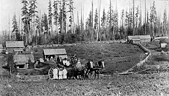
Settlers at their home on the west side of Oakville, around 1890.
-
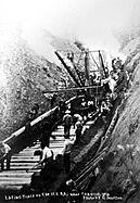
Track being laid for the railroad near Oakville, around 1890.
-
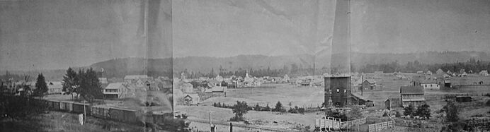
Oakville in 1906.


The Oakville Blobs Mystery
On August 7, 1994, something strange happened in Oakville. A resident reported that a clear, jelly-like substance had fallen from the sky. She worried it made her and her mother sick. She also thought it might have caused her kitten to die. When the "Oakville blobs" appeared again, samples were collected. A local doctor first said the substance had human blood cells. But later tests showed no cell parts.
People had many ideas about what the blobs could be. Some wondered if it was waste from an airplane toilet. Others thought it might be tiny pieces of dead jellyfish. These pieces might have evaporated and mixed with rain clouds. Tests also found two types of bacteria in the blobs. Today, there are no samples left to test.
This strange event was reported by news outlets like The New York Times. It was also featured on TV shows like Unsolved Mysteries and Monsters and Mysteries in America.
Geography
Oakville is on the north side of the Chehalis River. It is located just below where the Chehalis and Black Rivers meet. This area often experiences floods. Big floods happened in 1996 and 2007. These floods caused a lot of damage to homes, animals, and property. In 2016, a group called the Chehalis River Basin Flood Authority spent money to study the flooding. Reports showed that about 35 homes were affected. Roads were closed about three times per flood, and flooding usually happened twice a year.
To the north, Oakville is next to the hills of the Capitol State Forest. The area has many hills, valleys, rivers, and thick forests.
Climate
Oakville has a climate known as a warm-summer Mediterranean climate. This means it has warm, dry summers and mild, wet winters.
| Climate data for Oakville | |||||||||||||
|---|---|---|---|---|---|---|---|---|---|---|---|---|---|
| Month | Jan | Feb | Mar | Apr | May | Jun | Jul | Aug | Sep | Oct | Nov | Dec | Year |
| Record high °F (°C) | 66 (19) |
75 (24) |
80 (27) |
91 (33) |
98 (37) |
100 (38) |
105 (41) |
105 (41) |
100 (38) |
90 (32) |
74 (23) |
66 (19) |
105 (41) |
| Mean daily maximum °F (°C) | 45.3 (7.4) |
49.7 (9.8) |
54.2 (12.3) |
60.1 (15.6) |
66.5 (19.2) |
71.5 (21.9) |
77.1 (25.1) |
77.3 (25.2) |
72.4 (22.4) |
62.1 (16.7) |
51.8 (11.0) |
45.9 (7.7) |
61.2 (16.2) |
| Mean daily minimum °F (°C) | 32.2 (0.1) |
33.4 (0.8) |
34.7 (1.5) |
37.4 (3.0) |
41.7 (5.4) |
46.8 (8.2) |
49.7 (9.8) |
49.9 (9.9) |
46.0 (7.8) |
41.1 (5.1) |
36.3 (2.4) |
33.8 (1.0) |
40.3 (4.6) |
| Record low °F (°C) | −8 (−22) |
3 (−16) |
13 (−11) |
20 (−7) |
22 (−6) |
22 (−6) |
33 (1) |
25 (−4) |
23 (−5) |
16 (−9) |
2 (−17) |
−6 (−21) |
−8 (−22) |
| Average precipitation inches (mm) | 8.25 (210) |
6.34 (161) |
5.84 (148) |
3.83 (97) |
2.35 (60) |
1.78 (45) |
0.68 (17) |
1.15 (29) |
2.44 (62) |
4.99 (127) |
7.72 (196) |
9.02 (229) |
54.39 (1,382) |
| Average snowfall inches (cm) | 3.2 (8.1) |
0.9 (2.3) |
0.8 (2.0) |
0 (0) |
0 (0) |
0 (0) |
0 (0) |
0 (0) |
0 (0) |
0 (0) |
0.3 (0.76) |
1.4 (3.6) |
6.6 (16.76) |
| Average precipitation days (≥ 0.01 inch) | 18 | 15 | 17 | 14 | 11 | 8 | 4 | 5 | 8 | 13 | 18 | 19 | 150 |
Population and People
| Historical population | |||
|---|---|---|---|
| Census | Pop. | %± | |
| 1910 | 465 | — | |
| 1920 | 396 | −14.8% | |
| 1930 | 469 | 18.4% | |
| 1940 | 418 | −10.9% | |
| 1950 | 372 | −11.0% | |
| 1960 | 377 | 1.3% | |
| 1970 | 460 | 22.0% | |
| 1980 | 537 | 16.7% | |
| 1990 | 493 | −8.2% | |
| 2000 | 675 | 36.9% | |
| 2010 | 684 | 1.3% | |
| 2020 | 715 | 4.5% | |
| U.S. Decennial Census 2020 Census |
|||
2010 Census Information
In 2010, Oakville had 684 people living in 260 households. About 176 of these were families. The city had about 1368 people per square mile. There were 291 housing units in total.

Most people in Oakville were White (86.5%). There were also Native American (5.1%), Asian (0.9%), and African American (0.6%) residents. About 4.1% were from other races, and 2.6% were from two or more races. About 6.6% of the population was Hispanic or Latino.
In the households, 36.9% had children under 18. About 46.2% were married couples. The average household had 2.63 people. The average family had 3.08 people.
The average age in Oakville was 37.1 years. About 26% of residents were under 18. About 14% were 65 or older. The population was almost evenly split between males (49.1%) and females (50.9%).
Economy

In its early years, Oakville's economy was strong because of the lumber industry. Logging and sawmills created many jobs. This led to other businesses opening up to serve the workers. As the timber industry became less active, many of these businesses closed.
Today, Oakville has a few main businesses. These include a small grocery store and some diners. There is also an organic bedding company called Holy Lamb Organics. An auction house and a chip plant also operate here. Many farms are located on the edges of the city. Oakville also has a chamber of commerce, which helps local businesses.
Arts and Culture
Oakville hosts several fun events each year. In July, there is an Independence Day parade. This parade temporarily closes a part of U.S. Highway 12. Later in the summer, the city holds the Zucchini Jubilee. Other local traditions include a tree lighting and an egg hunt. The city also has a Saint Patrick's Day dinner, a harvest festival, and a spaghetti dinner.
The city's library is part of the Timberland Regional Library system. The library shares a building with the city hall.
Oakville is next to the land of the Confederated Tribes of the Chehalis Reservation. The tribe provides many services to its members. They help keep the cultural heritage of the area alive.
Parks and Recreation
Oakville has a great park called Al Brandt Municipal Park. It is located across from city hall. The park has a playground, a picnic shelter, and a basketball court.
The area around Oakville offers many outdoor activities. You can go boating, fishing, and swimming in the Chehalis and Black rivers to the south. To the north, the Capitol State Forest is perfect for hiking, hunting, camping, horseback riding, and mountain biking.
The Oakville Regional Event Center hosts different competitions. These can range from rodeos to adventure races.
Education

The Oakville School District No. 400 has one elementary school, one middle school, and one high school. In May 2018, it served 241 students in Grays Harbor County. A Board of Directors manages the district. This board has five members, who are elected for four-year terms. The superintendent leads the daily operations of the district. The school board appoints the superintendent.
The original Oakville elementary school was built in 1953. It began to be taken down in November 2021. This happened after a plan to rebuild and update the school campus was approved in 2020. The plan cost $5.6 million. It paid for a new elementary building and helped fix parts of the high school. Another grant of $4.6 million covered more upgrades. New programs were also started, like a preschool and a new library at the elementary building. The new school was finished and opened in late 2022.
Notable People
- Hazel Pete (1914–2003), a skilled basket weaver from the Chehalis tribe.
- Katherine Van Winkle Palmer (1895–1982), a famous scientist who studied ancient fossils (paleontologist).
- Frank Hinman Waskey (1875–1964), a delegate who represented the District of Alaska.
See also
 In Spanish: Oakville (Washington) para niños
