Oecusse facts for kids
Quick facts for kids
Oecusse
|
|||
|---|---|---|---|
|
Municipality and
Special Administrative Region |
|||
|
|||
|
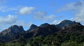
Mountains in Oecusse in 2015
|
|||
|
|||
|
|||
|
OpenStreetMap
|
|||
| Sovereign state | |||
| Capital | Pante Macassar | ||
| Area | |||
| • Total | 813.6 km2 (314.1 sq mi) | ||
| Area rank | 8th | ||
| Population
(Census of 15 October 2022)
|
|||
| • Total | 80,685 | ||
| • Rank | 6th | ||
| • Density | 99.170/km2 (256.850/sq mi) | ||
| • Density rank | 4th | ||
| Households (2015 census) | |||
| • Total | 14,345 | ||
| • Rank | 6th | ||
| Time zone | UTC+09:00 (TLT) | ||
| ISO 3166 code | TL-OE | ||
| HDI (2017) | 0.553 medium · 13th |
||
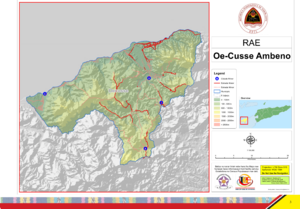
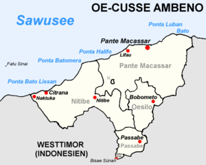
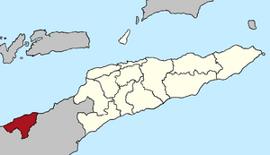
Oecusse, also known as Oecusse-Ambeno, is a special part of East Timor. It's called an exclave because it's separated from the main part of East Timor. It's surrounded by land belonging to Indonesia. Oecusse is also a municipality and the only Special Administrative Region (SAR) in East Timor.
Oecusse is located on the northern coast of the western part of Timor island. The Savu Sea is to its north. The capital city of Oecusse is Pante Macassar, which is sometimes called Oecussi Town.
Contents
What's in a Name?
The name Oecusse comes from the traditional name of Pante Macassar and the area around it. This place was once the center of a traditional kingdom. The larger historic area was known as Ambeno.
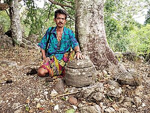
The word "Oe-Kussi" is where "Oecusse" comes from. In the local language, "Oe" means "water". The meaning of "Kussi" is debated. Some say it refers to a type of traditional clay pot, making "Oe-Kussi" mean "water pot". There's a legend about a special stone, the "Cussi", in the village of Banafi. Others believe Kussi was a local ruler.
The name "Ambeno" also comes from two words: "Ama" or "am" meaning "father" or "king", and "Benu", the name of two legendary rulers.
During the time when Portugal ruled, both "Oecusse" and "Ambeno" were used to talk about this area. Later, the name "Oecusse-Ambeno" became common. Today, the official name is "Oe-Cusse Ambeno".
Geography of Oecusse
Land and Mountains
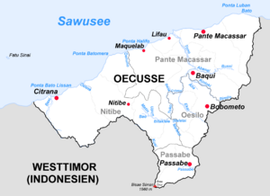
Oecusse SAR covers about 813.6 square kilometers. It's almost completely surrounded by Indonesia, except for its northern coast which faces the Savu Sea. The main part of East Timor is about 58 kilometers to the east.
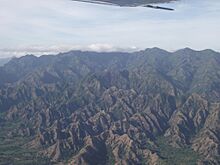
Near the coast, Oecusse has flat plains and savanna (grasslands). Further inland, the land rises into dry hills and then mountains, some reaching up to 1000 meters high. The main river is the Tono River, which flows into the Savu Sea. During the dry season, this river can almost dry up.
The highest point in Oecusse is Bisae Súnan, which is 1560 meters tall. Other mountains include Sapu (1259 meters) and Manoleu (1171 meters). About 30% of Oecusse is covered by forests, mostly eucalyptus trees.
Oecusse shares a border with Indonesia that is about 300 kilometers long. There are several places where people can cross the border, like at Sacato and Passabe.
Climate and Weather
Oecusse has a tropical savanna climate. This means it has a hot, wet, and humid season from December to April. The dry season, from May to November, is also hot but less humid.
Temperatures in the coastal areas are usually around 31-33°C during the day and 20-25°C at night. In higher areas, the temperature is cooler. Oecusse gets between 1000 and 2500 millimeters of rain each year. During the rainy season, some areas can become cut off due to flooding.
| Climate data for Oecusse (1919–1963) | |||||||||||||
|---|---|---|---|---|---|---|---|---|---|---|---|---|---|
| Month | Jan | Feb | Mar | Apr | May | Jun | Jul | Aug | Sep | Oct | Nov | Dec | Year |
| Record high °C (°F) | 32.3 (90.1) |
31.3 (88.3) |
33.4 (92.1) |
34.6 (94.3) |
34.8 (94.6) |
33.8 (92.8) |
33.2 (91.8) |
33.8 (92.8) |
34.7 (94.5) |
35.4 (95.7) |
33.6 (92.5) |
32.0 (89.6) |
35.4 (95.7) |
| Mean daily maximum °C (°F) | 29.7 (85.5) |
29.3 (84.7) |
29.8 (85.6) |
30.4 (86.7) |
30.7 (87.3) |
30.3 (86.5) |
29.6 (85.3) |
29.1 (84.4) |
28.8 (83.8) |
29.4 (84.9) |
30.6 (87.1) |
30.3 (86.5) |
29.8 (85.6) |
| Daily mean °C (°F) | 27.3 (81.1) |
27.0 (80.6) |
27.2 (81.0) |
27.6 (81.7) |
27.7 (81.9) |
27.1 (80.8) |
26.2 (79.2) |
26.0 (78.8) |
26.3 (79.3) |
27.5 (81.5) |
28.4 (83.1) |
27.9 (82.2) |
27.2 (81.0) |
| Mean daily minimum °C (°F) | 24.9 (76.8) |
23.6 (74.5) |
23.1 (73.6) |
22.8 (73.0) |
22.8 (73.0) |
22.0 (71.6) |
20.8 (69.4) |
20.4 (68.7) |
20.3 (68.5) |
22.0 (71.6) |
23.6 (74.5) |
23.8 (74.8) |
22.5 (72.5) |
| Record low °C (°F) | 20.5 (68.9) |
21.6 (70.9) |
19.0 (66.2) |
20.4 (68.7) |
18.5 (65.3) |
16.0 (60.8) |
15.6 (60.1) |
16.4 (61.5) |
17.0 (62.6) |
18.0 (64.4) |
20.9 (69.6) |
21.8 (71.2) |
15.6 (60.1) |
| Average rainfall mm (inches) | 282.0 (11.10) |
228.6 (9.00) |
205.5 (8.09) |
89.0 (3.50) |
36.6 (1.44) |
7.7 (0.30) |
6.2 (0.24) |
2.6 (0.10) |
1.3 (0.05) |
15.6 (0.61) |
54.2 (2.13) |
177.3 (6.98) |
1,106.6 (43.54) |
| Average rainy days (≥ 0.1 mm) | 16 | 15 | 13 | 7 | 2 | 1 | 1 | 0 | 0 | 2 | 5 | 14 | 76 |
| Average relative humidity (%) | 78 | 78 | 76 | 74 | 68 | 63 | 65 | 67 | 71 | 76 | 75 | 77 | 72 |
| Mean monthly sunshine hours | 182.9 | 166.7 | 248.0 | 264.0 | 294.5 | 279.0 | 297.6 | 310.0 | 351.0 | 316.2 | 294.0 | 235.6 | 3,239.5 |
| Mean daily sunshine hours | 5.9 | 5.9 | 8.0 | 8.8 | 9.5 | 9.3 | 9.6 | 10.0 | 11.7 | 10.2 | 9.8 | 7.6 | 8.8 |
| Source: Deutscher Wetterdienst | |||||||||||||
History of Oecusse
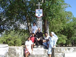
Oecusse was one of the first places on the island of Timor where the Portuguese settled. Because of this, it is often called the "cradle" of East Timor.
Around 1556, a priest named António Taveiro began missionary work on Timor's north coast. By 1569, a village called "Alifao" (Lifau) was on European maps. It was a good landing spot for Portuguese traders looking for sandalwood. The area was ruled by the Ambeno kingdom.
In 1641, Portuguese influence grew when priests baptized the royal families of Ambeno and other kingdoms. People of mixed European and Timorese descent, called Topasses, became powerful. They used Lifau as their main base and made a lot of money trading sandalwood.
In 1702, Lifau became the official capital of the Portuguese colony. However, there were often fights between the Portuguese governor and the Topasses. In 1769, the capital was moved from Lifau to Dili because of these attacks. Most of West Timor then came under Dutch control.
In 1859, Portugal and the Netherlands signed a treaty to divide the island. West Timor became Dutch, and East Timor became Portuguese. This made Oecusse an exclave, surrounded by Dutch territory. In 1912, there was a revolt against the Portuguese, but it was quickly stopped. The final border was set in 1916.
Indonesian forces invaded Oecusse on June 6, 1975. Even under Indonesian rule, Oecusse was part of the province of East Timor. Like many parts of the country, Oecusse suffered a lot of damage before the 1999 vote for independence. More than 90% of its buildings and roads were destroyed. Oecusse became part of the independent country of East Timor on May 20, 2002.
In November 1999, Australian troops arrived in Oecusse to help secure the area. They were later replaced by Jordanian troops.
Administrative Posts
Oecusse is divided into four main areas called administrative posts:
- Nitibe
- Oesilo
- Pante Macassar (where the capital Pante Macassar is located)
- Passabe
These administrative posts are further divided into 18 smaller areas called sucos (villages).
People of Oecusse
Population and Groups
In 2022, Oecusse had a population of 80,176 people. The main ethnic group is the Atoni Pah Meto, also known as the Meto people. They also live in Indonesian West Timor.
Languages Spoken
The main local language in Oecusse is Uab Meto, also called Baikeno. Portuguese is an official language and is used in schools and government, but not many people speak it fluently.
Before 1999, Indonesian was widely used. Now, Tetum is the main language for government, education, and public life in East Timor. Most people in Oecusse understand and speak Tetum.
Religion
Most people in Oecusse are Roman Catholic (99.3%). A small number are Protestant (0.6%). In East Timor, many Catholics also follow traditional beliefs and practices, like honoring sacred sites and spirits. This mix of beliefs is often called 'adat'.
Getting Around Oecusse
By Air
The Rota do Sandalo International Airport in Oecusse was opened in 2019. It's the main way to fly into Oecusse. The airport was built on an older airstrip near Pante Macassar.
By Road
Main roads connect Pante Macassar to places like Sacato and Bobometo. These places are on the border with Indonesia and have official border crossings. The Sacato crossing is important because it's on the shortest land route between Oecusse and the main part of East Timor.
A network of smaller roads links other areas within Oecusse to Pante Macassar. In 2017, the Noefefan Bridge was opened over the Tono River. This bridge helps people from areas west of the river reach Pante Macassar and its markets, even during the rainy season.
By Sea
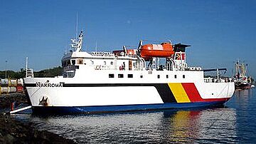
A ferry called the Berlin Nakroma travels between Oecusse and Dili. It makes two trips a week, and the journey takes about 12 hours.
Notable People
- Cristina Amaral, the first female pilot in East Timor
See also
 In Spanish: Región administrativa especial de Oecusse-Ambeno para niños


