
Bristol City Centre facts for kids
Quick facts for kids Bristol City Centre |
|
|---|---|
| Central Business District | |
.jpg) Roofscape of central Bristol |
|

Bristol City Centre
|
|
| Unitary authority |
|
| Country | England |
| Sovereign state | United Kingdom |
| Post town | BRISTOL |
| Postcode district | BS1, BS8 |
| Dialling code | 0117 |
| UK Parliament |
|
Bristol City Centre is the main hub of Bristol, England. It's where a lot of the city's shopping, culture, and businesses are located. You can find it north of the New Cut section of the River Avon. It's surrounded by areas like Clifton, Kingsdown, and St Pauls.
Many important places are in the city centre. These include the Bristol Royal Infirmary (a big hospital), the Bristol Royal Hospital for Children, and the BBC offices. The main campus of the University of Bristol is here too. You'll also find the city's main courts, the Temple Meads railway station, and the Bristol bus station. For shopping, there's Park Street, Broadmead, and Cabot Circus. Plus, there are lots of places to enjoy music, theatre, and food!
Contents
Bristol's Old Heart: The Historic Centre
The very old part of Bristol was right next to Bristol Bridge. This was the city's heart in the Middle Ages. Four main streets met at a spot called the High Cross. These streets were High Street, Wine Street, Broad Street, and Corn Street.
For a long time, people thought this was also where Bristol first started in Saxon times. Later discoveries suggested it might have been a bit further east, in what is now Castle Park. However, more recent finds around Small Street support the idea that the city began closer to the High Cross.
Before World War II, this area was Bristol's main shopping district. It had many old, narrow streets like Wine Street and Mary le Port Street. Sadly, much of it was badly damaged during the Bristol Blitz in 1940. But some parts, like the areas around Broad Street, Corn Street, and St Nicholas Market, survived. They still have many historic buildings today.
The Centre: A Modern Hub
The River Frome used to flow right next to Bristol's old centre. In the late 1800s, parts of this river were covered over. This new area became the main spot for Bristol's tramway network. People called it the Tramways Centre for a long time, even after the trams stopped running in 1941. Now, it's simply known as The Centre.
Between 1936 and 1938, The Centre got even bigger. More of the River Frome was covered up. This made space for a new road called the Inner Circuit Road. Over time, the western side of this road has been changed. Now, The Centre is much more friendly for people walking, cycling, and using public transport.
Broadmead: A Shopping Destination
After World War II, the area northeast of the historic centre, called Broadmead, was rebuilt. This happened even though many people didn't want it. The new streets and shops in Broadmead became the city's main shopping area. Many buildings from the 1950s were built to be useful and affordable. They weren't always the most exciting to look at.
In the 1980s, some of these buildings were taken down. This made way for The Galleries shopping centre. It's a shopping area with three levels, all under cover. In 2008, the shopping district grew even more. A new shopping centre called Cabot Circus opened in September 2008. It was built over the central ring road.
Harbourside: From Docks to Fun
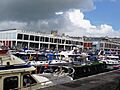
The City Docks were just south of The Centre. For many years, large ships used to come right into the city centre. However, after new, bigger docks opened in 1908 (Avonmouth Docks) and 1972 (Royal Portbury Dock), the City Docks were closed. This meant the old harbour buildings, like the tobacco warehouses, were no longer needed.
Since the 1990s, the harbourside has been completely changed. Many old warehouses have been made new again. They are now home to cool places like bars, restaurants, the Watershed Media Centre, and the Arnolfini art gallery. You can also find the We the Curious science centre here, which is a great place to explore and learn.
Images for kids
-
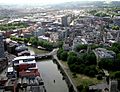
The channelled River Avon (the Floating Harbour) flows through the city centre; most of the central part of the City of Bristol is shown here
-
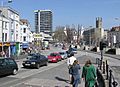
The Centre, seen from the bottom of Park Street
-
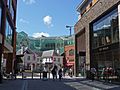
The North Entrance to the Galleries Shopping Centre, Broadmead
-
St. Augustine's Reach, Bristol Harbour
-
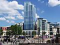
Radisson Blu Hotel and Broad Quay Serviced Apartments, The Centre
-
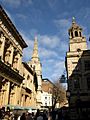
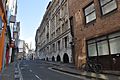
Corn Street, heart of the Old City
-
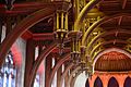
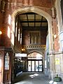
Hammerbeam roof in the Great Hall of the Wills Memorial Building, University of Bristol
-
BBC Bristol TV Studios, Whiteladies Road
-

Sculpture outside Bristol Children's Hospital
-
Crown Court, Small Street
-
Booking Office, Temple Meads Station
-
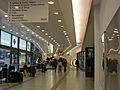
Bristol Bus Station
-
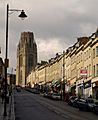
Park Street and Wills Memorial Building


