Oregon Trail (Ada County, Idaho segment) facts for kids
Quick facts for kids |
|
|
Oregon Trail
|
|

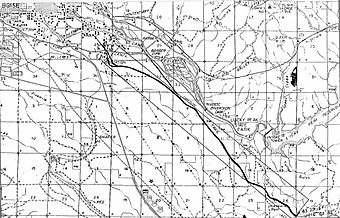
The Oregon Trail segment as depicted in 1972
|
|
| Nearest city | Boise, Idaho |
|---|---|
| Area | 0 acres (0 ha) |
| Built | 1840 |
| NRHP reference No. | 72000435 |
| Added to NRHP | October 18, 1972 |
The Oregon Trail (Ada County, Idaho segment) is a special part of the famous Oregon Trail located near Boise, Idaho. This section is about eight miles long. It shows where pioneers traveled as they entered the beautiful Boise Valley.
This part of the trail was added to the National Register of Historic Places (NRHP) in 1972. This means it's an important historical site. When it was added, you could still see the wide wagon tracks left by thousands of pioneers. In some places, the tracks were eight wagons wide!
Today, the Oregon Trail Reserve is a 77-acre park managed by Boise Parks and Recreation. It includes part of this historic trail segment. The Oregon Trail Recreation Area is another nearby spot that also protects a piece of the trail.
After this segment, the Oregon Trail continued along what is now Boise Avenue. The Capitol Boulevard Memorial Bridge is also known as the Oregon Trail Memorial Bridge. This bridge is located where pioneers used to cross the Boise River by ferry. From there, they continued west toward Caldwell. Today, 21 special markers, called obelisks, show the path of the Oregon Trail through Boise.
The Oregon Trail in Idaho
The Oregon Trail was a very important route for people moving west in the 1800s. Many pioneers traveled through Idaho on their way to the Oregon Country.
Early Explorers and Forts
In the 1830s, explorers like Nathaniel Jarvis Wyeth and Benjamin Bonneville traveled through the Rocky Mountains. They used a path called the South Pass. Wyeth built Fort Hall in 1834 in what is now southeastern Idaho. This fort was a key stop for travelers.
Also in 1834, Thomas McKay built Fort Boise in southwestern Idaho. By the 1840s, the route between these two forts became a very busy part of the Oregon Trail.
A geographer named Samuel Augustus Mitchell described the land. He wrote that the area between the Rocky and Blue mountains was "rocky, barren and broken." He noted that it had "stupendous mountain spurs" and little flat ground. Snow often covered the high areas for most of the year. He also mentioned that it rarely rained and no dew fell.
New Fort Boise and Boise City
Old Fort Boise was left empty in 1854. But a new Fort Boise was built in 1863. This new fort was located farther east. Right next to this new fort, Boise City was planned out in 1863. This is the city we know today as Boise.
Marking the Trail
In 1906, a man named Ezra Meeker placed the first marker in Boise. This marker was put there to remember the Oregon Trail. You can still see this marker today. It is at the southeast corner of the Idaho State Capitol grounds. These markers help us remember the incredible journey pioneers made.
 | Aaron Henry |
 | T. R. M. Howard |
 | Jesse Jackson |


