
Orme, Tennessee facts for kids
Quick facts for kids
Orme, Tennessee
|
|
|---|---|

Orme Depot
|
|

Location of Orme in Marion County, Tennessee.
|
|
| Country | United States |
| State | Tennessee |
| County | Marion |
| Area | |
| • Total | 4.13 sq mi (10.70 km2) |
| • Land | 4.13 sq mi (10.70 km2) |
| • Water | 0.00 sq mi (0.00 km2) |
| Elevation | 850 ft (260 m) |
| Population
(2020)
|
|
| • Total | 87 |
| • Density | 21.07/sq mi (8.13/km2) |
| Time zone | UTC-6 (Central (CST)) |
| • Summer (DST) | UTC-5 (CDT) |
| ZIP code |
37380
|
| Area code(s) | 423 |
| FIPS code | 47-56040 |
| GNIS feature ID | 1296488 |
Orme is a small town in Marion County, Tennessee, United States. It is part of the larger Chattanooga metropolitan area. In 2020, the town had a population of 87 people. This was a decrease from 126 people counted in the 2010 census.
Contents
History of Orme
Orme started as a coal mining community in the early 1890s. It was first known as Needmore. Mining here was slow to begin because the area was hard to reach. There were no good ways to transport the coal.
In the late 1890s, a businessman named Frederick Gates bought the mining operations. He worked with the Nashville, Chattanooga and St. Louis Railway to build a train line. The railroad agreed to build the line in 1902. This made it easier to move coal.
After getting the train line built, Gates sold the Needmore operation. Richard Orme Campbell (1860–1912) bought it. He renamed the company the "Campbell Coal and Coke Company." He also renamed the town "Orme" after his son, who had the same name. The name "Orme" was his mother's maiden name.
Campbell built many things in the town. He built a store, an office, homes for workers, schools, and a hotel. In just a few years, the town grew to have thousands of residents. It was a busy mining town.
In 1905, Campbell sold the Orme operation. The new owners called it the "Battle Creek Coal and Coke Company." By 1912, there were four mines. These mines reached high up into the Cumberland Plateau. Mules pulled rail cars full of coal to the mine entrances. From there, a train took the coal to a special loading area called a tipple. At its busiest, the mine shipped 1,000 tons of coal every day.
Orme's Decline and Water Solution
Major mining operations in Orme stopped after a miners' strike in 1939. The railroad company removed the train tracks. The metal was used for World War II efforts. After this, Orme began to shrink. The hotel closed in 1945, and the school closed in 1961. The post office shut down in 1970. Today, the old wooden railroad depot is one of the few buildings left from the town's mining days.
In 2007, Orme faced a big challenge. There was a severe drought in the southeastern United States. Orme depended on a creek and a natural spring for its water. These sources almost dried up. The town's water supply dropped from 60,000 gallons a day to only 5,000 gallons. This was not enough water for the town.
To help, trucks brought water to the town. This allowed the water system to run for three hours each evening. The mayor of Orme, Tony Reames, found a lasting solution. He arranged for Orme to connect to the water system of nearby Bridgeport, Alabama. This connection was made with a 2.5-mile (4.0 km) pipe. An emergency grant from the USDA paid for the project. This connection solved Orme's water problem for good.
Geography of Orme
Orme (which rhymes with "storm") is located in a narrow valley called Doran's Cove. This valley is surrounded by the Cumberland Plateau on three sides. Most of Orme's buildings are along Dry Creek, which drains the valley. The plateau walls rise almost a thousand feet high. The only opening is a narrow gap to the south.
South Pittsburg, Tennessee, is to the east across the plateau. Bridgeport, Alabama, is to the southeast. Russell Cave National Monument is just across the state line to the south.
A single paved road, Orme Road, connects Orme to Jackson County, Alabama. To reach Orme from Tennessee by paved road, you usually drive through Alabama. You take U.S. Route 72 south from South Pittsburg. Then you follow county roads 75 and 98 north through Doran's Cove. Orme Road starts at the state line. There is also a gravel road, Orme Mountain Road. This road connects Orme to Tennessee State Route 156 on top of the plateau to the north.
The town covers about 4.2 square miles (10.7 km2) of land. There is no water area within the town limits.
Population and People
Orme's population has changed over the years. Here is a look at the population counts from different census years:
| Historical population | |||
|---|---|---|---|
| Census | Pop. | %± | |
| 1910 | 653 | — | |
| 1920 | 522 | −20.1% | |
| 1930 | 466 | −10.7% | |
| 1940 | 277 | −40.6% | |
| 1950 | 230 | −17.0% | |
| 1960 | 171 | −25.7% | |
| 1970 | 122 | −28.7% | |
| 1980 | 181 | 48.4% | |
| 1990 | 150 | −17.1% | |
| 2000 | 124 | −17.3% | |
| 2010 | 126 | 1.6% | |
| 2020 | 87 | −31.0% | |
| Sources: | |||
In 2000, there were 124 people living in Orme. The average age was 44 years old. About 17.7% of the population was under 18 years old. About 12.1% were 65 years or older.
Notable People
- Jimmy Outlaw (1913-2006), a professional baseball player, was from Orme.
Images for kids
-
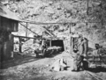
Entrance to a mine at Orme in the early 1910s
-
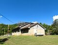
Orme town hall and fire department


See also
 In Spanish: Orme (Tennessee) para niños
