
Whiteford Township, Michigan facts for kids
Quick facts for kids
Whiteford Township, Michigan
|
|
|---|---|
.jpg)
Whiteford Township Administrative Offices
|
|

Location within Monroe County and the state of Michigan
|
|

Whiteford Township, Michigan
Location in Michigan

Whiteford Township, Michigan
Location in the United States
|
|
| Country | United States |
| State | Michigan |
| County | Monroe |
| Established | 1834 |
| Area | |
| • Total | 40.24 sq mi (104.22 km2) |
| • Land | 39.72 sq mi (102.87 km2) |
| • Water | 0.52 sq mi (1.35 km2) |
| Elevation | 679 ft (207 m) |
| Population
(2020)
|
|
| • Total | 4,590 |
| • Density | 115.6/sq mi (44.6/km2) |
| Time zone | UTC-5 (Eastern (EST)) |
| • Summer (DST) | UTC-4 (EDT) |
| ZIP Codes | |
| Area code(s) | 734 |
| FIPS code | 26-115-86740 |
| GNIS feature ID | 1627261 |
Whiteford Township is a community in Monroe County, Michigan, USA. It is a type of local government area called a civil township. In 2020, about 4,590 people lived there.
Contents
A Look Back: Whiteford Township's History
Whiteford Township was created in March 1834. It was formed from parts of Erie Township and the old Port Lawrence Township. The township is named after General David White. He was the first leader of the township and an early settler.
When it was first created, Whiteford Township was much larger. It even included land that is now part of Ohio. This area was called the Toledo Strip. Both Ohio and Michigan claimed this land during a disagreement known as the Toledo War. This bigger Whiteford Township included most of what is now Sylvania and parts of Toledo.
By December 1836, the land dispute was settled. Ohio was given the Toledo Strip. Because of this, Whiteford Township lost all its land south of the new state border.
Throughout the 1800s, most of the land in the township was used for farming. Many families worked as farmers. In 1880, over 95% of the people living there were farmers or farm workers. Some people worked as merchants or in factories. For example, the community of Ottawa Lake had a large mill where many residents worked.
In 1880, the township had 2,044 people. By 1900, the population grew slightly to 2,050.
Communities in Whiteford Township
Whiteford Township is home to several communities, some of which are still active and some that are part of its history.
- Gert was a community that used to exist here. It had its own post office from 1885 to 1904. You can see Gert on an old map of Monroe County from 1911.
- Ottawa Lake is a community that is not officially a city. It has its own post office with the ZIP Code 49267. This post office serves most of the township.
- Pleasant View was another community from the past. It was located along the old Toledo, Ann Arbor and North Michigan Railway line. You can find it on an 1876 map of Whiteford Township.
- Saint Anthony is a community that started in 1920. It is located between Ottawa Lake and Temperance.
- Whiteford was the very first settlement in the township. It was founded when Whiteford Township was created in 1834. It had a post office for a short time in 1835 before it moved to Toledo.
- Whiteford Center (sometimes called Whiteford Centre) is a community in the eastern part of the township. It was settled around 1840 and had its own post office from 1867 to 1905.
Geography of Whiteford Township
Whiteford Township is located in the southwest corner of Monroe County. Its western border is next to Lenawee County. Its southern border is the state line with Ohio. The city of Sylvania, Ohio, is just south of the township.
The township covers about 40.24 square miles (104.22 square kilometers). Most of this area is land, about 39.72 square miles (102.87 square kilometers). A small part, about 0.52 square miles (1.35 square kilometers), is water.
Main Roads in the Township
 US 23 is a major highway that runs through the township from north to south.
 US 223 is another highway that goes west from US 23 into Lenawee County.
Population Changes Over Time
| Historical population | |||
|---|---|---|---|
| Census | Pop. | %± | |
| 1850 | 696 | — | |
| 1860 | 1,136 | 63.2% | |
| 1870 | 1,427 | 25.6% | |
| 1880 | 2,044 | 43.2% | |
| 1890 | 1,901 | −7.0% | |
| 1900 | 2,050 | 7.8% | |
| 1910 | 1,686 | −17.8% | |
| 1920 | 1,741 | 3.3% | |
| 1930 | 2,205 | 26.7% | |
| 1940 | 2,314 | 4.9% | |
| 1950 | 2,793 | 20.7% | |
| 1960 | 3,641 | 30.4% | |
| 1970 | 4,059 | 11.5% | |
| 1980 | 4,660 | 14.8% | |
| 1990 | 4,433 | −4.9% | |
| 2000 | 4,420 | −0.3% | |
| 2010 | 4,602 | 4.1% | |
| 2020 | 4,590 | −0.3% | |
| U.S. Decennial Census | |||
In 2000, there were 4,420 people living in Whiteford Township. There were 1,582 households, which are groups of people living together. About 35% of these households had children under 18 living with them. Most households (69.4%) were married couples.
The average household had about 2.77 people. The average family had about 3.17 people.
The population was spread out by age. About 26.2% of the people were under 18 years old. About 10.9% were 65 years or older. The average age in the township was 39 years.
Images for kids
-
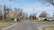
Community of Whiteford Center -
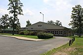
Whiteford High School -
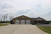
Whiteford Township Fire Department -
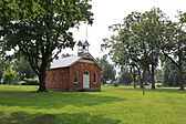
Defunct Whiteford Schoolhouse, built in 1888 -

St. Michael Lutheran Church


See also
 In Spanish: Municipio de Whiteford (Míchigan) para niños
