
Padres Butte facts for kids
Quick facts for kids Padres Butte |
|
|---|---|

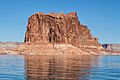
East aspect of Padres Butte, June 2015
|
|
| Highest point | |
| Elevation | 4,043 ft (1,232 m) <= |
| Prominence | 463 ft (141 m) |
| Isolation | 1.29 mi (2.08 km) |
| Parent peak | Dominguez Butte |
| Geography | |

Padres Butte
Location in Utah

Padres Butte
Location in the United States
|
|
| Location | Glen Canyon National Recreation Area San Juan County, Utah, U.S. |
| Parent range | Colorado Plateau |
| Topo map | USGS Gunsight Butte |
| Geology | |
| Age of rock | Jurassic |
| Type of rock | Entrada Sandstone |
| Climbing | |
| Easiest route | class 5.x climbing |
Padres Butte is a cool butte (which is like a small, flat-topped mountain) in Utah, United States. It's located near Lake Powell, a big lake in San Juan County. This special place is part of the Glen Canyon National Recreation Area.
About Padres Butte
The very top of Padres Butte is about 4,043 feet (1,232 meters) high. It used to be an island in Lake Powell. However, the lake's water levels have gone down. Because of this, land now connects the butte to the nearby Padre Point.
Padres Butte is famous for a historical event called the Crossing of the Fathers. This was a place where people could cross the Colorado River. It had a series of sandbars (shallow areas in the river) that made it possible. This crossing was about a mile west of the butte. The name "Padres Butte" was officially given in 1961. This was done by the United States Board on Geographic Names.
Climate
Padres Butte is in a desert climate zone. This means it has very hot and dry summers. The winters are chilly, but they get very little snow.
Images for kids
-
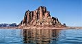
Southeast aspect
-
Northeast aspect
-
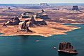
Padres Butte in lower right corner


