
Dominguez Butte facts for kids
Quick facts for kids Dominguez Butte |
|
|---|---|

Northeast aspect
|
|
| Highest point | |
| Elevation | 4,476 ft (1,364 m) |
| Prominence | 656 ft (200 m) |
| Isolation | 0.66 mi (1.06 km) |
| Parent peak | Point 4700 |
| Geography | |

Dominguez Butte
Location in Utah

Dominguez Butte
Location in the United States
|
|
| Location | Navajo Reservation San Juan County, Utah, U.S. |
| Parent range | Colorado Plateau |
| Topo map | USGS Gunsight Butte |
| Geology | |
| Age of rock | Jurassic |
| Type of rock | Entrada Sandstone |
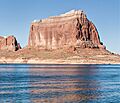
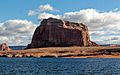
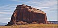
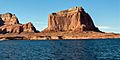
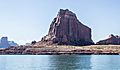
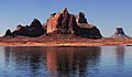
Dominguez Butte is a tall sandstone summit in southern Utah. It stands 4,476 feet (1,364 meters) high. You can find it south of Lake Powell in San Juan County.
This impressive rock formation is located on Navajo Nation land. It's about 13 miles northeast of Page, Arizona. Dominguez Butte rises more than 700 feet above the land around it. This makes it a very noticeable landmark in the area.
You might have even seen Dominguez Butte in a movie! It made a brief appearance in the 1968 film Planet of the Apes. In the movie, a spaceship crashes into Lake Powell near the butte.
Contents
What is Dominguez Butte Made Of?
Dominguez Butte is a type of hill called a butte. A butte is a tall, flat-topped hill with steep sides. It is mostly made of a type of rock called Entrada Sandstone.
Other nearby buttes, like Padres Butte to the north and Boundary Butte to the south, are also made of this sandstone. Below the Entrada Sandstone, you would find layers of Carmel Formation and Page Sandstone. Above it, there's Romana Sandstone, topped by Morrison Formation.
This butte is on the southern edge of the Great Basin Desert. It is also part of the larger Colorado Plateau region. Any rain that falls on Dominguez Butte eventually flows into the Colorado River.
A Look Back in History
Dominguez Butte is named after a Spanish explorer. His name was Francisco Atanasio Domínguez (1740–1805). He was a Franciscan missionary.
In 1776, Domínguez led an expedition with another explorer, Escalante. They tried to cross the Colorado River at a place called Lee's Ferry. But the river was too difficult to cross there.
So, on November 7, 1776, they found another spot. This crossing was about two miles north of where Dominguez Butte is today. They called it the Crossing of the Fathers. The path down to the river was very steep. They had to carve steps into the rocks. This helped their animals get down safely. Today, this historic crossing is covered by the waters of Lake Powell.
The United States Board on Geographic Names officially named this butte "Dominguez Butte" in 1976. This was done to honor Francisco Atanasio Domínguez.
Climate Around Dominguez Butte
The area around Dominguez Butte has a dry climate. This means it has hot, very dry summers. The winters are chilly, but there is very little snow.
The best times to visit are during spring and fall. The weather is usually more pleasant then.
Images for kids
-
Northeast aspect
-
West aspect
-
West aspect
-
East aspect
-
Dominguez Butte from norhwest
-
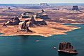
Aerial view looking south. Dominguez Butte left of center nearest water's edge.
(Tower Butte upper right corner. Padres Butte in lower right corner. LeChee Rock centered on horizon) -
Dominguez Butte centered, Tower Butte far right. From the north.


