LeChee Rock facts for kids
Quick facts for kids LeChee Rock |
|
|---|---|
| Leche Benchmark | |

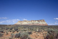
Southwest aspect
|
|
| Highest point | |
| Elevation | 5,900 ft (1,800 m) |
| Prominence | 730 ft (220 m) |
| Isolation | 11.39 mi (18.33 km) |
| Parent peak | Point 5940 |
| Geography | |

LeChee Rock
Location in Arizona

LeChee Rock
Location in the United States
|
|
| Location | Navajo Reservation Coconino County, Arizona, U.S. |
| Parent range | Colorado Plateau |
| Topo map | USGS LeChee Rock |
| Geology | |
| Age of rock | Jurassic |
| Type of rock | Sandstone |
LeChee Rock is a tall rock formation made of sandstone, standing about 5,900 feet (1,800 meters) high. You can find it in northern Arizona, near Lake Powell and the town of Page. It's located on land belonging to the Navajo Nation.
LeChee Rock stands out, rising over 900 feet (274 meters) above the land around it. This makes it a famous landmark in the area. You can easily spot it from Arizona State Route 98 and even from places like Alstrom Point.
The name LeChee comes from the Navajo language word Łichíí, which means "red." This name refers to the reddish, burgundy-colored leaves of a special medicinal plant found there. The official spelling "LeChee Rock" was adopted in 2004 by the United States Board on Geographic Names. Before that, it was known as "Leche-e Rock."
What is LeChee Rock Made Of?
LeChee Rock is part of the Colorado Plateau, a huge area of high desert. It's mostly made of a type of rock called sandstone. Sandstone forms when tiny grains of sand get pressed together over millions of years.
The top layers of LeChee Rock are made of Romana Sandstone. Below that, you'll find the Escalante Member of Entrada Sandstone. The very top is covered by the Salt Wash Member of the Morrison Formation. At the bottom of the rock, there's a reddish layer called the Carmel Formation. This reddish rock is what gives LeChee Rock its name.
All these rock layers formed during the Jurassic period, which was a very long time ago! When it rains, water flows off LeChee Rock into nearby Navajo and Antelope Canyons. This water eventually makes its way to Lake Powell, which is part of the huge Colorado River system.
Weather Around LeChee Rock
The area around LeChee Rock has a desert climate. This means it has very hot and dry summers. Winters are chilly, but there isn't much snow.
The best times to visit LeChee Rock are during spring and fall. The weather is usually mild and pleasant then.
| Climate data for Page, Arizona | |||||||||||||
|---|---|---|---|---|---|---|---|---|---|---|---|---|---|
| Month | Jan | Feb | Mar | Apr | May | Jun | Jul | Aug | Sep | Oct | Nov | Dec | Year |
| Record high °F (°C) | 64 (18) |
72 (22) |
82 (28) |
91 (33) |
102 (39) |
107 (42) |
109 (43) |
106 (41) |
100 (38) |
93 (34) |
77 (25) |
66 (19) |
109 (43) |
| Mean daily maximum °F (°C) | 43.1 (6.2) |
50.3 (10.2) |
59.5 (15.3) |
68.5 (20.3) |
78.5 (25.8) |
90.2 (32.3) |
95.1 (35.1) |
92.0 (33.3) |
83.5 (28.6) |
69.7 (20.9) |
53.8 (12.1) |
43.7 (6.5) |
69.0 (20.6) |
| Mean daily minimum °F (°C) | 26.3 (−3.2) |
30.4 (−0.9) |
37.0 (2.8) |
43.6 (6.4) |
52.6 (11.4) |
62.3 (16.8) |
68.3 (20.2) |
66.4 (19.1) |
58.4 (14.7) |
46.6 (8.1) |
34.7 (1.5) |
27.1 (−2.7) |
46.1 (7.8) |
| Record low °F (°C) | −11 (−24) |
6 (−14) |
18 (−8) |
25 (−4) |
31 (−1) |
44 (7) |
56 (13) |
46 (8) |
40 (4) |
24 (−4) |
16 (−9) |
1 (−17) |
−11 (−24) |
| Average precipitation inches (mm) | 0.61 (15) |
0.48 (12) |
0.65 (17) |
0.50 (13) |
0.40 (10) |
0.14 (3.6) |
0.58 (15) |
0.69 (18) |
0.66 (17) |
0.99 (25) |
0.56 (14) |
0.48 (12) |
6.74 (171.6) |
| Average snowfall inches (cm) | 2.1 (5.3) |
1.2 (3.0) |
0.2 (0.51) |
0 (0) |
0 (0) |
0 (0) |
0 (0) |
0 (0) |
0 (0) |
0 (0) |
0.5 (1.3) |
1.4 (3.6) |
5.4 (13.71) |
| Average precipitation days (≥ 0.01 in) | 4.5 | 4.0 | 5.2 | 3.5 | 3.2 | 1.7 | 4.6 | 5.2 | 4.5 | 4.3 | 3.2 | 3.9 | 47.8 |
| Average snowy days (≥ 0.1 in) | 0.9 | 0.6 | 0.3 | 0 | 0 | 0 | 0 | 0 | 0 | 0 | 0.2 | 0.6 | 2.6 |
| Source: NOAA | |||||||||||||
Gallery
-
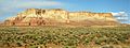
West aspect
-
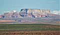
Northwest aspect
-
-
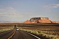
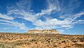
South aspect from Highway 98
-
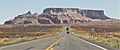
Northwest aspect from Highway 98
-