
Boundary Butte facts for kids
Quick facts for kids Boundary Butte |
|
|---|---|

Northwest aspect
|
|
| Highest point | |
| Elevation | 4,934 ft (1,504 m) |
| Prominence | 897 ft (273 m) |
| Isolation | 2.58 mi (4.15 km) |
| Parent peak | Tower Butte |
| Geography | |

Boundary Butte
Location in Utah

Boundary Butte
Location in the United States
|
|
| Location | Navajo Reservation San Juan County, Utah, U.S. |
| Parent range | Colorado Plateau |
| Topo map | USGS Gunsight Butte |
| Geology | |
| Age of rock | Jurassic |
| Type of rock | Entrada Sandstone |
| Climbing | |
| Easiest route | class 5.x climbing |
Boundary Butte is a tall, flat-topped mountain called a butte. It's about 4,934 feet (1,504 meters) high. You can find it in southern Utah, near Lake Powell. This butte is on Navajo Nation land. It's about 11.5 miles (18.5 km) northeast of Page, Arizona. Boundary Butte stands about 1,200 feet (366 meters) above Lake Powell, making it a famous landmark. It gets its name because it sits right on the border between Utah and Arizona!
What is Boundary Butte Made Of?
Boundary Butte is a butte made mostly of a type of rock called Entrada Sandstone. This sandstone is also found in other nearby buttes, like Dominguez Butte to the north and Tower Butte to the southwest. Below the Entrada Sandstone, you can find layers of Carmel Formation and Page Sandstone closer to the lake. Above the Entrada layers are Romana Sandstone and Morrison Formation.
This area is part of the Colorado Plateau, which is a large, high desert region. Any rain or snow that falls on Boundary Butte eventually flows into the Colorado River.
Gallery
-
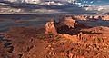
Aerial view looking north, with Boundary Butte centered
-
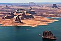
Aerial view of west aspect
-
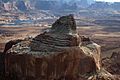
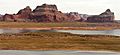
From northwest
-
Aerial view looking south. Dominguez Butte left of center, nearest to water's edge.
Boundary Butte behind right. (Tower Butte upper right corner. Padres Butte in lower right corner. LeChee Rock centered on horizon) -
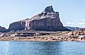
Boundary Butte to the right


.jpg)
Weather at Boundary Butte
Boundary Butte is in a dry climate zone, according to the Köppen climate classification system. This means it has very hot and dry summers. Winters are chilly, but there isn't much snow. The best times to visit are during spring and fall, when the weather is mild and pleasant.
| Climate data for Page, Arizona | |||||||||||||
|---|---|---|---|---|---|---|---|---|---|---|---|---|---|
| Month | Jan | Feb | Mar | Apr | May | Jun | Jul | Aug | Sep | Oct | Nov | Dec | Year |
| Record high °F (°C) | 64 (18) |
72 (22) |
82 (28) |
91 (33) |
102 (39) |
107 (42) |
109 (43) |
106 (41) |
100 (38) |
93 (34) |
77 (25) |
66 (19) |
109 (43) |
| Mean daily maximum °F (°C) | 43.1 (6.2) |
50.3 (10.2) |
59.5 (15.3) |
68.5 (20.3) |
78.5 (25.8) |
90.2 (32.3) |
95.1 (35.1) |
92.0 (33.3) |
83.5 (28.6) |
69.7 (20.9) |
53.8 (12.1) |
43.7 (6.5) |
69.0 (20.6) |
| Mean daily minimum °F (°C) | 26.3 (−3.2) |
30.4 (−0.9) |
37.0 (2.8) |
43.6 (6.4) |
52.6 (11.4) |
62.3 (16.8) |
68.3 (20.2) |
66.4 (19.1) |
58.4 (14.7) |
46.6 (8.1) |
34.7 (1.5) |
27.1 (−2.7) |
46.1 (7.8) |
| Record low °F (°C) | −11 (−24) |
6 (−14) |
18 (−8) |
25 (−4) |
31 (−1) |
44 (7) |
56 (13) |
46 (8) |
40 (4) |
24 (−4) |
16 (−9) |
1 (−17) |
−11 (−24) |
| Average precipitation inches (mm) | 0.61 (15) |
0.48 (12) |
0.65 (17) |
0.50 (13) |
0.40 (10) |
0.14 (3.6) |
0.58 (15) |
0.69 (18) |
0.66 (17) |
0.99 (25) |
0.56 (14) |
0.48 (12) |
6.74 (171.6) |
| Average snowfall inches (cm) | 2.1 (5.3) |
1.2 (3.0) |
0.2 (0.51) |
0 (0) |
0 (0) |
0 (0) |
0 (0) |
0 (0) |
0 (0) |
0 (0) |
0.5 (1.3) |
1.4 (3.6) |
5.4 (13.71) |
| Average precipitation days (≥ 0.01 in) | 4.5 | 4.0 | 5.2 | 3.5 | 3.2 | 1.7 | 4.6 | 5.2 | 4.5 | 4.3 | 3.2 | 3.9 | 47.8 |
| Average snowy days (≥ 0.1 in) | 0.9 | 0.6 | 0.3 | 0 | 0 | 0 | 0 | 0 | 0 | 0 | 0.2 | 0.6 | 2.6 |
| Source: NOAA | |||||||||||||
