
Papaloapan River facts for kids
Quick facts for kids Papaloapan River |
|
|---|---|
 |
|

Map of the Papaloapan River drainage basin before construction of the Cerro de Oro Dam
|
|
| Country | Mexico |
| States | Oaxaca, Veracruz |
| Cities | Tuxtepec, Otatitlán, Tlacojalpan, Chacaltianguis, Cosamaloapan, Carlos A. Carrillo, Amatitlán, Tlacotalpan, Alvarado |
| Physical characteristics | |
| Main source | Río Grande (Oaxaca) Santa María Yavesía, Oaxaca 3,700 m (12,100 ft) |
| River mouth | Gulf of Mexico Alvarado municipality, Veracruz 0 m (0 ft) |
| Length | 354 km (220 mi) |
| Basin features | |
| Basin size | 46,517 km2 (17,960 sq mi) |
The Papaloapan River is one of the most important rivers in the Mexican state of Veracruz. Its name comes from the Nahuatl language, and it means "river of the butterflies".
In 1518, an explorer named Juan de Grijalva saw the river and called it Río de Alvarado.
Contents
Where the River Starts and Flows
The Papaloapan River begins in the Sierra Madre de Oaxaca mountains. This is near the border between the states of Veracruz and Oaxaca.
How the River is Formed
The Papaloapan River is created when two other rivers, the Santo Domingo River and the Valle Nacional River, join together. This happens southwest of San Juan Bautista Tuxtepec in Oaxaca. The Tonto River is another big river that flows into the Papaloapan.
The River's Journey to the Sea
The Papaloapan River flows for about 122 km (76 mi) towards the northeast. It winds its way through flat land near the coast. Finally, it empties into the Alvarado Lagoon, which then connects to the Gulf of Mexico.
The Papaloapan River Basin
A river basin is all the land where water drains into a specific river. The Papaloapan River basin is very large.
Size and Population
The Papaloapan River basin covers about 46,517 km2 (17,960 sq mi). This makes it the second largest river basin in all of Mexico! About 3.3 million people live in this area.
Cities Along the River
Many towns and cities are located along the banks of the Papaloapan River. Two important cities are San Juan Bautista Tuxtepec and Tlacotalpan in Veracruz.
Dealing with Floods
For a long time, the Papaloapan River basin had a big problem with frequent floods. These floods could cause a lot of damage, especially when big storms called cyclones also hit the area.
Past Flooding Problems
One very bad flood happened in September 1944. It covered a huge area of land, about 470,000 hectares (1,200,000 acres). This flood caused a lot of harm to people and their homes.
Building Dams to Help
To control the floods, people built dams. The Miguel Alemán Dam was built on the Tonto River in 1955. This dam helped reduce the flooding. However, even after this dam, some floods still happened, like in 1958 and 1969.
Over time, the Santo Domingo River carried a lot of dirt and mud, called silt, into the Papaloapan. This silt made the river's path narrower, which made flooding worse.
The Cerro de Oro Dam
To solve this, the Cerro de Oro Dam was built in 1989 on the Santo Domingo River. This dam greatly helped to control the floods. Now, the floods are much smaller and easier to manage.
Future Plans for the River Basin
The states of Oaxaca and Veracruz are working together to make the Papaloapan River basin even better. They have plans to help the people and the environment.
Improving the Area
Some of the plans include:
- Using irrigation to help farms grow more food.
- Encouraging forestry (growing trees) and fish farming.
- Making roads and river travel better.
All these projects are carefully planned to avoid harming the environment. People have studied how to prevent environmental damage in the area.
See also
 In Spanish: Río Papaloapan para niños
- List of longest rivers of Mexico
Images for kids
-
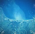
A satellite view of the Papaloapan River flowing into the Gulf of Mexico.
-
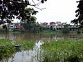
The Papaloapan River as it passes by Tuxtepec.
-
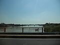
A view of the river from a bridge.
-
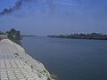
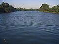
The Papaloapan River near Carlos A. Carrillo, Veracruz.
-
The Papaloapan River in front of Cosamaloapan.


