
Sierra Madre de Oaxaca facts for kids
Quick facts for kids Sierra Madre de Oaxaca |
|
|---|---|
| Sierra Norte de Oaxaca | |

View of the Sierra Juárez from San Juan Yagila, in the Rincon de Ixtlan Region, Oaxaca, México
|
|
| Geography | |

Sierra Madre de Oaxaca lies west of Chivela Pass and north of the Sierra Madre del Sur range
|
|
| Country | Mexico |
| State/Province | Oaxaca |
| Parent range | Sierra Madre Oriental |
The Sierra Madre de Oaxaca is a large mountain range in southern Mexico. It is mostly found in the state of Oaxaca. Parts of it also reach north into the states of Puebla and Veracruz.
Contents
Geography of the Mountains
This mountain range starts near Pico de Orizaba, which is a very tall volcano. It stretches southeast for about 300 kilometers (186 miles) until it reaches the Isthmus of Tehuantepec. The mountains in the Sierra Madre de Oaxaca are usually around 2,500 meters (8,200 feet) high. Some peaks are even taller, reaching over 3,000 meters (9,800 feet). The highest point in the range is Cerro Zempoaltépetl.
Parts of the Sierra Madre de Oaxaca
The Sierra Madre de Oaxaca is made up of several smaller mountain areas. These include:
- The Sierra de Zongolica and Sierra Mazateca in the north.
- The Sierra Juárez in the middle.
- The Sierra de Villa Alta and Sierra Ixtlán further south.
- The Sierra Mixe in the southeast.
Weather and Rivers
The eastern side of these mountains gets a lot of rain. This is because winds carrying moisture from the Gulf of Mexico hit the mountains and drop their water. On the western side, it's much drier. This happens because the mountains block the rain, creating a "rain shadow." Dry valleys like the Tehuacán and Cuicatlán valleys are found here.
Other big mountain ranges nearby are the Sierra Madre del Sur to the south, near the Pacific Ocean, and the Sierra Madre de Chiapas to the east.
Many rivers start in these mountains. The Blanco River begins in the north and carves a huge canyon as it flows to the Gulf of Mexico. The Papaloapan River drains a large part of the northern and central Sierra. Rivers like the Verde and Tehuantepec flow from the southern slopes into the Pacific Ocean.
Caves and Rocks
Much of the Sierra Madre de Oaxaca is made of limestone rock. Over time, water has worn away this limestone, creating amazing karst landscapes. This includes many large cave systems. Some famous ones are the Chevé Caves and the Huautla Caves. These caves are some of the deepest in the world!
Ecology and Nature
The Sierra Madre de Oaxaca is home to different types of forests and natural areas, called ecoregions.
- The Sierra Madre de Oaxaca pine-oak forests are found on the higher parts of the mountains, above 1,600 meters (5,200 feet). These forests have many pine and oak trees.
- Below 1,600 meters on the eastern slopes, you'll find the humid Oaxacan montane forests. These areas are very wet and green.
- To the east, in the dry Tehuacan Valley matorral ecoregion, there are dry lands with shrubs.
- The Southern Pacific dry forests are found to the south, near the Pacific Coast.
Mountain Subranges and Cultures
The Sierra Madre de Oaxaca system can be divided into many smaller mountain areas, each with its own unique nature and human cultures.
Sierra Mazateca
The Sierra Mazateca is in the northwest part of Oaxaca state. Its mountains reach about 2,600 meters (8,500 feet) high. This area is the homeland of the Mazatec people. Important towns here include Huautla de Jiménez.
Sierra Juárez
The Sierra Juárez is the land of the Sierra Zapotecs. It is famous as the birthplace of Benito Juárez, who was Mexico's first president from an indigenous background. Main towns in the Sierra Juárez are Ixtlan de Juárez and Villa Hidalgo Yalalag.
Sierra Mixe
The Sierra Mixe is located to the east, where the mountains get lower towards the Isthmus of Tehuantepec. This area is home to the Mixe people. They are believed to be descendants of the ancient Olmecs. Major Mixe towns include San Pablo & San Pedro Ayutla. The main peak here is Zempoateptl, which is a sacred mountain for the Mixe people.
Notable People from the Sierra Madre de Oaxaca
Many important people have come from these mountains:
- Benito Juárez: He was the first indigenous president of Mexico. He was born in a Zapotec community now called Guelatao de Juárez.
- Ricardo Flores Magón and Enrique Flores Magón: These two brothers were famous Mexican activists. They were born in the Sierra Mazateca.
- María Sabina: She was a respected Mazatec curandera (healer) from Huautla de Jiménez.
Images for kids
-
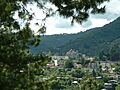
Ixtlan de Juarez is an important Zapotec town in the Sierra Juarez region.
-
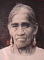
María Sabina, a Mazatec healer.
-
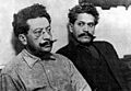
Ricardo Flores Magón (left) and his brother Enrique Flores Magón in 1916.


See also
 In Spanish: Sierra Madre de Oaxaca para niños
- Sierra Madre de Oaxaca topics
- Mountain ranges of Mexico
- Sierra Madre de Oaxaca pine-oak forests
- Sierra Norte de Oaxaca — a region within this mountain range.
