Paradeep facts for kids
Quick facts for kids
Paradeep
Paradip
|
||
|---|---|---|
|
Town
|
||
| Paradweep | ||
|
|
||
| Nickname(s):
Smart Industrial Port City
|
||
| Country | India | |
| State | Odisha | |
| District | Jagatsinghpur | |
| Founded by | Pandit Jawaharlal Nehru | |
| Government | ||
| • Type | Municipality | |
| • Body | Paradeep Municipality | |
| Area | ||
| • Total | 105 km2 (41 sq mi) | |
| Elevation | 1 m (3 ft) | |
| Population
(2011)
|
||
| • Total | 68,585 | |
| • Density | 653.2/km2 (1,692/sq mi) | |
| Demonym(s) | Paradipians | |
| Languages | ||
| • Official | Odia | |
| Time zone | UTC+5:30 (IST) | |
| Vehicle registration | OR-21 | |
Paradeep, also known as Paradip, is an important industrial and seaport city in Odisha, India. It is about 80 kilometers (50 miles) from Cuttack city. Paradeep is located in the Jagatsinghpur district.
This town became a local council (called an NAC) on September 27, 1979. Later, it became a full municipality on December 12, 2002. The closest airport for travelers is Biju Patnaik International Airport.
Paradeep Municipality includes five main villages: Udachandrapur, Chauliapalanda, Sandhakuda, Bijayachandrapur, and Bhitaragarh. Many big companies have set up their businesses here. These include IFFCO, Paradeep Phosphates Limited, and several oil companies like Indian Oil Corporation.
Contents
History of Paradeep
In the early 1600s, Paradeep and nearby areas were connected to Cuttack by the Mahanadi river. Goods were moved using the Brahmani and Dhamra rivers. However, this stopped over time as the riverbeds filled with sand.
In 1819, the British built a harbor called False Point, which was north of where Paradeep is today. This harbor was very important during the great famine of 1866. It was used to bring in food to help the people affected by the famine.
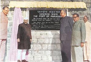
After India became independent, a small port was built in Paradeep in 1958. The government then decided to build a much larger port. The foundation stone for the Paradip Port was laid on January 3, 1962. This was done by Pandit Jawaharlal Nehru, who was the Prime Minister of India at that time.
The port was finished in 1965 and opened on March 12, 1966. Paradip Port became the eighth major port in India. It was also the first major deep-sea port built on India's east coast after independence. The Paradip Port Trust was created in 1967 to manage and develop the port.
Geography and Climate
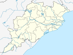
Paradeep is located at 20°10′N 86°24′E / 20.16°N 86.40°E. It is very close to sea level, with an average height of only 1 meter (about 3 feet) above the sea.
Paradeep's Weather
Paradeep has a warm climate. Here's a look at the average temperatures and rainfall:
| Climate data for Paradeep (1981–2010, extremes 1969–2012) | |||||||||||||
|---|---|---|---|---|---|---|---|---|---|---|---|---|---|
| Month | Jan | Feb | Mar | Apr | May | Jun | Jul | Aug | Sep | Oct | Nov | Dec | Year |
| Record high °C (°F) | 33.2 (91.8) |
36.2 (97.2) |
39.3 (102.7) |
40.7 (105.3) |
41.4 (106.5) |
42.4 (108.3) |
38.0 (100.4) |
39.2 (102.6) |
36.4 (97.5) |
36.0 (96.8) |
34.0 (93.2) |
32.6 (90.7) |
42.4 (108.3) |
| Mean daily maximum °C (°F) | 27.0 (80.6) |
28.9 (84.0) |
31.0 (87.8) |
32.0 (89.6) |
32.9 (91.2) |
32.5 (90.5) |
31.4 (88.5) |
31.3 (88.3) |
31.7 (89.1) |
31.8 (89.2) |
30.1 (86.2) |
28.0 (82.4) |
30.7 (87.3) |
| Mean daily minimum °C (°F) | 16.5 (61.7) |
19.9 (67.8) |
23.5 (74.3) |
25.7 (78.3) |
26.6 (79.9) |
26.7 (80.1) |
26.0 (78.8) |
26.0 (78.8) |
26.0 (78.8) |
24.4 (75.9) |
20.2 (68.4) |
16.7 (62.1) |
23.2 (73.8) |
| Record low °C (°F) | 9.6 (49.3) |
12.0 (53.6) |
13.4 (56.1) |
16.0 (60.8) |
17.5 (63.5) |
18.5 (65.3) |
18.1 (64.6) |
17.8 (64.0) |
19.6 (67.3) |
16.0 (60.8) |
12.0 (53.6) |
10.4 (50.7) |
9.6 (49.3) |
| Average rainfall mm (inches) | 9.4 (0.37) |
19.4 (0.76) |
33.5 (1.32) |
33.3 (1.31) |
95.2 (3.75) |
222.9 (8.78) |
282.0 (11.10) |
367.6 (14.47) |
284.3 (11.19) |
195.9 (7.71) |
86.5 (3.41) |
10.8 (0.43) |
1,640.9 (64.60) |
| Average rainy days | 0.7 | 1.4 | 1.4 | 2.0 | 4.2 | 9.1 | 13.2 | 14.0 | 11.0 | 6.7 | 2.6 | 0.5 | 66.6 |
| Average relative humidity (%) (at 17:30 IST) | 71 | 75 | 80 | 84 | 83 | 83 | 85 | 85 | 83 | 78 | 71 | 68 | 79 |
| Source: India Meteorological Department | |||||||||||||
Transportation in Paradeep
Paradeep is well-connected by roads and railways. It is located on National Highway 53 and State Highway No. 12. The town also has an electric broad-gauge railway system.
You can travel by bus from Paradeep to cities like Rourkela, Kolkata, Puri, and Konark. There are also bus and train services connecting Paradeep to Cuttack.
Paradip Port: A Major Seaport
The Port of Paradip is the most important port in Odisha. It is also one of the largest ports on India's east coast. The port is located on the Bay of Bengal.
It is an artificial harbor, meaning it was built by people. Ships reach the port through human-made lagoons. In 2017–2018, the port handled over 100 million tonnes of goods. This included a lot of thermal coal and iron ore.
The port has a large concrete storage area of 55,000 m2 (590,000 sq ft). This area can hold about 1000 TEUs (which are like large shipping containers). It also has three mobile cranes, a facility for loading and unloading goods, and a special jetty for rolling cargo.
Industries in Paradeep
Paradeep is a hub for many important industries. Some of the major companies and plants here include:
- Paradip Refinery: A large oil refinery run by Indian Oil Corporation Limited. It can process 15 million tonnes of oil each year.
- Paradeep Phosphates Limited: A company that makes fertilizer.
- Multi Modal Logistics Park: Managed by Container Corporation of India Limited.
- Paradeep Plastic Park Limited.
- Goa Carbon Ltd.: This plant processes petroleum coke.
- IFFCO: Another large fertilizer plant.
- Essar Steel: Has a plant that makes iron pellets.
- Marketing terminals for major oil companies like IOCL, BPCL, and HPCL.
- Cargill: An edible oil plant.
- Skol Breweries Ltd.: An East Coast Brewery.
Paradeep is also expecting new steel plants to be built, including a huge one by POSCO from South Korea. There are also plans for new aluminum refineries, power plants, and a petrochemical complex.
Paradeep has been chosen as one of six major areas in India for developing Petroleum, Chemicals and Petrochemicals Investment Regions (PCPIRs). This means there are plans for huge investments, possibly up to US$68.84 billion, in an area covering 284 square kilometres (110 sq mi).
Population and People
According to the 2001 Indian census, Paradeep had a population of 73,633 people. About 58% of the population was male and 42% was female. This difference is because many young workers moved to the area for industrial jobs.
Paradeep has a good literacy rate of 73%. This is higher than the national average for India, which is 59.5%. For males, the literacy rate is 79%, and for females, it is 65%. About 12% of the people living in Paradeep are under 6 years old.
Images for kids
See also
 In Spanish: Paradip para niños


