
Paradise, Kansas facts for kids
Quick facts for kids
Paradise, Kansas
|
|
|---|---|

Paradise watertower (2005)
|
|

Location within Russell County and Kansas
|
|

|
|
| Country | United States |
| State | Kansas |
| County | Russell |
| Founded | 1887 |
| Incorporated | 1924 |
| Named for | paradise |
| Area | |
| • Total | 0.25 sq mi (0.64 km2) |
| • Land | 0.25 sq mi (0.64 km2) |
| • Water | 0.00 sq mi (0.00 km2) |
| Elevation | 1,693 ft (516 m) |
| Population
(2020)
|
|
| • Total | 35 |
| • Density | 140/sq mi (54.7/km2) |
| Time zone | UTC-6 (CST) |
| • Summer (DST) | UTC-5 (CDT) |
| ZIP code |
67658
|
| Area code | 785 |
| FIPS code | 20-54325 |
| GNIS ID | 472527 |
Paradise is a small city located in Russell County, Kansas, United States. It's known for its peaceful name and quiet community. As of the 2020 census, only 35 people lived there.
Contents
History of Paradise
How Paradise Got Its Name
In 1859, a group of hunters explored this area. They found a small stream, a "tributary," that led them to a great spot. This place had plenty of water, trees, and bison. One hunter, James R. Mead, called the spot "paradise." Because of this, the stream became known as Paradise Creek.
Early Settlements and Growth
The first post office in the area opened in 1875. It was also named Paradise. Later, in 1887, a company called Union Townsite Company started a new town. They built it near the creek and the post office. They named this new town Ivamar. It was named after Iva Marr, the daughter of a local rancher.
The Paradise post office moved to Ivamar the next year. But it kept its original name. So, people started calling the town both Paradise and Ivamar. By 1891, the Union Pacific Railroad listed its train stop there as Paradise. They added Ivamar in parentheses.
Becoming a City
The community grew a lot in the 1890s. It soon had a school, shops downtown, and buildings for the railroad. By 1910, about 200 people lived there. In 1924, Ivamar officially became a city. This is called being "incorporated." At that time, it finally changed its name to Paradise. The number of people living in Paradise has slowly gone down since the 1930s.
Geography of Paradise
Where is Paradise?
Paradise is in north-central Kansas. It's about 3.5 miles (5.6 km) west of U.S. Route 281. You can find it on Kansas Highway 18 (K-18). The city is about 127 miles (204 km) northwest of Wichita. It's also 233 miles (375 km) west of Kansas City. The county seat, Russell, is about 15 miles (24 km) north-northwest of Paradise.
Natural Surroundings
Paradise is located on the north side of Paradise Creek. This creek flows into the Saline River. The area is part of the Smoky Hills region. This region is a part of the larger Great Plains. Another stream, Eagle Creek, flows south along the east side of Paradise. It also joins Paradise Creek.
The city of Paradise covers a total area of about 0.25 square miles (0.64 square kilometers). All of this area is land.
Population of Paradise
| Historical population | |||
|---|---|---|---|
| Census | Pop. | %± | |
| 1930 | 178 | — | |
| 1940 | 161 | −9.6% | |
| 1950 | 145 | −9.9% | |
| 1960 | 134 | −7.6% | |
| 1970 | 145 | 8.2% | |
| 1980 | 89 | −38.6% | |
| 1990 | 66 | −25.8% | |
| 2000 | 64 | −3.0% | |
| 2010 | 49 | −23.4% | |
| 2020 | 35 | −28.6% | |
| U.S. Decennial Census | |||
Population Changes Over Time
The population of Paradise has changed quite a bit over the years. In 1930, there were 178 people living there. By 2010, the population had dropped to 49 people. The most recent count in 2020 showed 35 residents. This means Paradise is a very small community today.
Economy of Paradise
Jobs and Work
In 2012, most adults in Paradise who were old enough to work had jobs. Many people worked in sales and office jobs. Others worked in management, business, or science. Some jobs were in natural resources, construction, and maintenance. There were also jobs in production, transportation, and service. The biggest employers were in public administration, finance, and other services.
Cost of Living
Living in Paradise is not very expensive. The cost of living there is lower than the average for the United States. For example, the typical home value in 2012 was $16,900. This is much lower than in many other places.
Education in Paradise
School District
The public schools in Paradise are part of the Natoma–Paradise–Waldo USD 399 school district. This district is based in Natoma.
Paradise High School
Paradise High School closed its doors in 1974. This happened when the school districts of Paradise and Waldo joined with Natoma. The school mascot for the Paradise Pirates was a pirate. The Paradise Pirates boys' track and field team won the Kansas State High School championship in 1971.
Infrastructure in Paradise
Transportation
K-18 is a main road that runs east and west. It goes near Paradise from the northwest. Then it turns east, just north of the city. Paradise Road is another paved county road that leads into the city from the south.
Utilities
Western Electric provides electricity to the homes in Paradise. Gorham Telephone offers landline phone service. They also provide cable television and internet access. Most people in Paradise use propane for heating their homes.
Media in Paradise
Paradise is in the Wichita-Hutchinson, Kansas television market. This means that residents watch TV channels that serve this larger area.
Culture in Paradise
Unique Architecture
Paradise has some special buildings made from "Post Rock Limestone." Early settlers found that there weren't many trees for building. But there was a lot of limestone. So, they used this stone to build houses and other structures. They even used it for fence posts!
The city's watertower and the old Kennedy Hotel are examples of this unique architecture. They were recently added to the National Register of Historic Places. This means they are recognized as important historical sites. They were even featured in an article in the Salina Journal newspaper.
Gallery
-
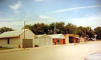
Businesses in downtown Paradise (2007)
-
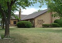
Paradise United Methodist Church (2005)


See also
 In Spanish: Paradise (Kansas) para niños
