
Parkfield, California facts for kids
Quick facts for kids
Parkfield
|
|
|---|---|

Parkfield Cafe
|
|

Parkfield
Location in California

Parkfield
Location in the United States
|
|
| Country | United States |
| State | California |
| County | Monterey County |
| Elevation | 1,529 ft (466 m) |
Parkfield is a small, unincorporated community in Monterey County, California. It's located on Little Cholame Creek, about 21 miles (34 km) east of Bradley. The town sits at an elevation of about 1,529 feet (466 meters) above sea level. In 2007, signs in Parkfield stated its population was just 18 people!
Parkfield is nestled in the Temblor Range, a mountain chain between California's San Joaquin Valley and its Central Coast. Long ago, people came here for mining and to start farms. But the mines eventually ran out of valuable minerals. Today, most of the 18 residents are ranchers and farmers. Parkfield also attracts visitors for horse-related events, hunting, a bluegrass music festival, and its amazing earthquake history. The town's motto is "Be here when it happens," which hints at its unique connection to earthquakes.
A post office served Parkfield from 1884 to 1954. The town was first called Russelsville, but the post office didn't approve that name. So, "Parkfield" was chosen because the area looked like a park, with many oak trees. The town's ZIP Code is 93451, and it's in area code 805.
Contents
Parkfield: The Earthquake Capital of the World
Parkfield is famous for being one of the most studied earthquake zones on Earth. It sits right on top of the San Andreas Fault, a huge crack in the Earth's crust. This fault is one of the longest and most active in the United States. In Parkfield, the fault looks like a dry creek bed for part of the year.
What is the San Andreas Fault?
The San Andreas Fault is where two giant pieces of the Earth's crust, called tectonic plates, meet. On one side is the North American Plate, and on the other is the Pacific Plate. These plates are always moving, but very slowly. Sometimes, they get stuck, and when they finally slip, it causes an earthquake.
You can see this movement in Parkfield! There's a bridge over the creek that has piers (supports) on either side. Since the bridge was built in 1936, these piers have moved more than five feet relative to each other. This slow, steady movement is called aseismic creep. The bridge even has signs telling drivers they are crossing the plate boundary!
Why Does Parkfield Have So Many Earthquakes?
Since at least 1857, Parkfield has experienced a major earthquake (magnitude 6 or greater) about every 22 years. Because of this regular pattern, the US Geological Survey (USGS) predicted a similar earthquake would hit by 1993. It didn't happen exactly then, but on September 28, 2004, a magnitude 6.0 earthquake did strike at 10:15 AM Pacific Daylight Time.
How Do Scientists Study Earthquakes in Parkfield?
Parkfield is the most closely watched earthquake zone in the world. Scientists are constantly measuring many things here. They check the stress in the rocks, how heat flows through the ground, tiny earthquakes (microseismicity), and changes in the Earth's magnetic field (geomagnetism).
Since 1985, the United States Geological Survey has run "The Parkfield Experiment." This long-term project aims to understand the physics of earthquakes. Scientists want to know exactly what happens on the fault and in the surrounding area before, during, and after an earthquake. The information they gather from Parkfield might one day help them predict major earthquakes along the San Andreas Fault and around the world.
What is the San Andreas Fault Observatory at Depth (SAFOD)?
In 2004, work began on an amazing project just north of Parkfield called the San Andreas Fault Observatory at Depth (SAFOD). The goal of SAFOD was to drill a hole almost 2.5 miles (4 kilometers) deep into the Earth's crust, right across the San Andreas Fault!
The drilling finished in mid-2005. Scientists then installed many sensors deep inside the Earth to record earthquakes happening nearby. They hope that SAFOD will help them understand how small earthquakes start. This knowledge could then be used to understand bigger earthquakes. During the drilling, they found a mineral called serpentinite where the 2004 earthquake began. Serpentinite can turn into talc, which is a very soft mineral. This might explain why the plates can slip past each other more easily in this area.
Climate in Parkfield
Parkfield has a climate with hot summers and mild winters. The average high temperature in July is around 97.0°F (36.1°C), and in January, it's about 61.2°F (16.2°C). The area gets most of its rain in the winter months.
Notable Sights in Parkfield
-
Demonstration aseismic creep near the Parkfield Inn.
-
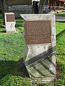
Tribute to the memory of Yokuts and other early settlers who lived in the Cholame area.
-
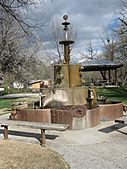
Water fountain constructed from old oil well drilling parts, located in the town's park.


