Parkinson, Queensland facts for kids
Quick facts for kids ParkinsonBrisbane, Queensland |
|||||||||||||||
|---|---|---|---|---|---|---|---|---|---|---|---|---|---|---|---|

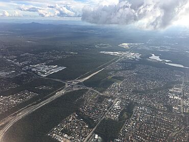
Aerial Image of Parkinson, 2019
|
|||||||||||||||
| Population | 11,148 (2021 census) | ||||||||||||||
| • Density | 1,360/km2 (3,500/sq mi) | ||||||||||||||
| Postcode(s) | 4115 | ||||||||||||||
| Area | 8.2 km2 (3.2 sq mi) | ||||||||||||||
| Time zone | AEST (UTC+10:00) | ||||||||||||||
| Location | 23.0 km (14 mi) S of Brisbane CBD | ||||||||||||||
| LGA(s) | City of Brisbane (Calamvale Ward) |
||||||||||||||
| State electorate(s) | Algester | ||||||||||||||
| Federal Division(s) | Rankin | ||||||||||||||
|
|||||||||||||||
Parkinson is a lively suburb located in the southern part of Brisbane, Queensland, Australia. It's a great place to live, with a growing community. In 2021 census, about 11,148 people called Parkinson home.
Contents
Exploring Parkinson's Location
Parkinson is about 23 kilometers (14 miles) south of the Brisbane CBD (that's the city center!). It's also right next to Logan City.
The Mount Lindesay Highway forms the eastern edge of Parkinson. The western side follows the Sydney–Brisbane rail corridor, which is a railway line. The Logan Motorway, a major road, cuts right through the middle of the suburb.
The northern part of Parkinson is mostly where people live, with houses and some parks. The southern area still has lots of natural bushland. However, some industrial buildings are starting to appear in the southeast. This corner is the very southernmost tip of the City of Brisbane.
A Look Back: Parkinson's History
Parkinson got its name on June 12, 1972. It was named after Henry Parkinson, who was a railway engineer. The Queensland Place Names Board decided on the name.
For many years, Parkinson was mostly bushland. But in the mid-1990s, new houses started to be built. By 2003, most of the northern areas had homes. More houses were built in the western part until 2008. In 2009, an area for businesses and factories was built in the southeast.
On October 13, 2011, Parkinson had a very strong thunderstorm. It brought powerful winds, large hailstones, and heavy rain. This storm was special because so much hail fell and piled up. It caused local floods, damaged roofs and cars, and led to power outages. Some of the ice from the storm didn't melt for a whole day!
Who Lives in Parkinson?
Parkinson is a diverse place with people from many different backgrounds.
In 2011 census, there were 9,539 people living here. Most people were born in Australia. However, many residents also came from countries like New Zealand, England, South Africa, China, and India. While most people spoke English at home, other languages like Mandarin, Cantonese, Hindi, and Spanish were also spoken.
The population of Parkinson has continued to grow. In 2016 census, there were 10,878 people. By 2021 census, the population reached 11,148 people.
Learning in Parkinson
Parkinson has some interesting schools that offer special programs.
- Ohana College is a private high school for students in Years 7 to 12. It's located on Sandstone Street. This school helps students who might be struggling with traditional schooling. It gives them a different way to learn and stay engaged.
- Australian Technology and Agricultural College – Parkinson is another private high school, for Years 10 to 12. It's also on Sandstone Place. This campus focuses on teaching students skills for jobs in trades and agriculture. It helps prepare them for work after school.
There are no government schools directly in Parkinson. However, there are several nearby. For primary school, students can go to Algester State School, Calamvale Community College, Stretton State College, or Browns Plains State School. For high school, options include Calamvale Community College, Stretton State College, and Browns Plains High State School.
 | Sharif Bey |
 | Hale Woodruff |
 | Richmond Barthé |
 | Purvis Young |


