Parsons, Tennessee facts for kids
Quick facts for kids
Parsons, Tennessee
|
|||
|---|---|---|---|
|
|||
| Motto(s):
Take Pride In Parsons!
|
|||

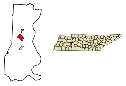
Location of Parsons in Decatur County, Tennessee.
|
|||
| Country | United States | ||
| State | Tennessee | ||
| County | Decatur | ||
| Area | |||
| • Total | 4.05 sq mi (10.48 km2) | ||
| • Land | 4.05 sq mi (10.48 km2) | ||
| • Water | 0.00 sq mi (0.00 km2) | ||
| Elevation | 495 ft (151 m) | ||
| Population
(2020)
|
|||
| • Total | 2,100 | ||
| • Density | 518.90/sq mi (200.37/km2) | ||
| Time zone | UTC-6 (Central (CST)) | ||
| • Summer (DST) | UTC-5 (CDT) | ||
| ZIP code |
38363
|
||
| Area code(s) | 731 | ||
| FIPS code | 47-57080 | ||
| GNIS feature ID | 1296893 | ||
Parsons is a city located in Decatur County, Tennessee, in the United States. In 2020, about 2,100 people lived there. It is the biggest city in Decatur County.
Contents
History of Parsons
Parsons was started around 1889 by the Tennessee Midland Railroad Company (TMRC). A man named Henry Myracle gave 143 acres of his land to the railroad company. He wanted them to build a town there.
The railroad company created the Parsons Improvement Co. to help manage the new town. Mr. Myracle continued to oversee the town's growth. The main train station was where the BP One Stop is today. A large area used for storing railroad ties was where the CB&S Bank now stands. There were also storage lots and pens for farm animals where Townsend Chevrolet is located. Near the train station, there was a big water tank and two places for farmers to pack their produce. The town also had a public water pump and a small park.
The part of the railroad that went to Perryville was called the "Pea Vine." The trains on this line were known as the "Hot Shot" or "Cannonball."
Geography of Parsons
Parsons is in the middle of Decatur County. It is located at 35.648780 degrees north and 88.123386 degrees west. Two main roads, U.S. Route 412 and U.S. Route 641, meet in the center of the city.
- U.S. Route 412 goes east about 69 miles to Columbia. It goes west about 42 miles to Jackson.
- U.S. Route 641 goes north about 30 miles to Camden. It goes south about 24 miles to Clifton.
Decaturville, which is the county seat, is about 5 miles south on U.S. Route 641.
Parsons covers a total area of about 4.05 square miles (10.7 square kilometers). All of this area is land.
The community of Perryville is about 5 miles east of Parsons, along the Tennessee River. Perryville is the oldest settlement in Decatur County. On August 9, 1930, the highest temperature ever recorded in Tennessee was in Perryville. It was 113 degrees Fahrenheit (45 degrees Celsius).
Climate in Parsons
Parsons has a humid subtropical climate. This means it has hot, humid summers and mild winters. The hottest temperature ever recorded in Parsons was 109 degrees Fahrenheit (43 degrees Celsius) on August 16, 2007. The coldest temperature recorded was -1 degree Fahrenheit (-18 degrees Celsius) on December 23–24, 2022.
| Climate data for Parsons, Tennessee, 1991–2020 normals, extremes 1998–present | |||||||||||||
|---|---|---|---|---|---|---|---|---|---|---|---|---|---|
| Month | Jan | Feb | Mar | Apr | May | Jun | Jul | Aug | Sep | Oct | Nov | Dec | Year |
| Record high °F (°C) | 75 (24) |
82 (28) |
88 (31) |
92 (33) |
95 (35) |
106 (41) |
105 (41) |
109 (43) |
103 (39) |
97 (36) |
88 (31) |
78 (26) |
109 (43) |
| Mean maximum °F (°C) | 69.1 (20.6) |
73.3 (22.9) |
81.7 (27.6) |
86.8 (30.4) |
90.7 (32.6) |
95.6 (35.3) |
97.5 (36.4) |
98.3 (36.8) |
94.8 (34.9) |
88.9 (31.6) |
78.5 (25.8) |
71.6 (22.0) |
99.7 (37.6) |
| Mean daily maximum °F (°C) | 50.4 (10.2) |
54.8 (12.7) |
64.0 (17.8) |
73.5 (23.1) |
80.7 (27.1) |
87.3 (30.7) |
90.9 (32.7) |
90.6 (32.6) |
85.1 (29.5) |
75.2 (24.0) |
63.1 (17.3) |
53.2 (11.8) |
72.4 (22.5) |
| Daily mean °F (°C) | 39.4 (4.1) |
43.1 (6.2) |
51.3 (10.7) |
60.1 (15.6) |
68.7 (20.4) |
76.2 (24.6) |
79.9 (26.6) |
78.9 (26.1) |
72.3 (22.4) |
61.0 (16.1) |
49.9 (9.9) |
42.1 (5.6) |
60.2 (15.7) |
| Mean daily minimum °F (°C) | 28.4 (−2.0) |
31.3 (−0.4) |
38.5 (3.6) |
46.7 (8.2) |
56.8 (13.8) |
65.2 (18.4) |
69.0 (20.6) |
67.2 (19.6) |
59.6 (15.3) |
46.8 (8.2) |
36.7 (2.6) |
31.1 (−0.5) |
48.1 (9.0) |
| Mean minimum °F (°C) | 11.7 (−11.3) |
14.4 (−9.8) |
22.2 (−5.4) |
30.7 (−0.7) |
41.1 (5.1) |
53.9 (12.2) |
58.8 (14.9) |
57.8 (14.3) |
46.7 (8.2) |
30.6 (−0.8) |
20.8 (−6.2) |
16.4 (−8.7) |
9.3 (−12.6) |
| Record low °F (°C) | 1 (−17) |
5 (−15) |
8 (−13) |
21 (−6) |
35 (2) |
45 (7) |
54 (12) |
48 (9) |
36 (2) |
21 (−6) |
14 (−10) |
−1 (−18) |
−1 (−18) |
| Average precipitation inches (mm) | 4.43 (113) |
5.03 (128) |
5.59 (142) |
5.29 (134) |
5.53 (140) |
4.04 (103) |
4.95 (126) |
4.05 (103) |
4.35 (110) |
4.23 (107) |
4.08 (104) |
5.51 (140) |
57.08 (1,450) |
| Average snowfall inches (cm) | 0.8 (2.0) |
0.4 (1.0) |
0.4 (1.0) |
0.0 (0.0) |
0.0 (0.0) |
0.0 (0.0) |
0.0 (0.0) |
0.0 (0.0) |
0.0 (0.0) |
0.0 (0.0) |
0.0 (0.0) |
0.0 (0.0) |
1.6 (4) |
| Average precipitation days (≥ 0.01 in) | 11.6 | 10.8 | 11.9 | 10.0 | 10.8 | 9.7 | 9.2 | 8.4 | 7.3 | 8.2 | 9.3 | 11.7 | 118.9 |
| Average snowy days (≥ 0.1 in) | 1.0 | 0.4 | 0.1 | 0.0 | 0.0 | 0.0 | 0.0 | 0.0 | 0.0 | 0.0 | 0.1 | 0.3 | 1.9 |
| Source 1: NOAA | |||||||||||||
| Source 2: National Weather Service (mean maxima/minima 2006–2020) | |||||||||||||
Population and People
| Historical population | |||
|---|---|---|---|
| Census | Pop. | %± | |
| 1920 | 429 | — | |
| 1930 | 915 | 113.3% | |
| 1940 | 1,079 | 17.9% | |
| 1950 | 1,640 | 52.0% | |
| 1960 | 1,859 | 13.4% | |
| 1970 | 2,167 | 16.6% | |
| 1980 | 2,422 | 11.8% | |
| 1990 | 2,033 | −16.1% | |
| 2000 | 2,452 | 20.6% | |
| 2010 | 2,373 | −3.2% | |
| 2020 | 2,100 | −11.5% | |
| Sources: | |||
2020 Census Information
In 2020, the census counted 2,100 people living in Parsons. There were 870 households and 527 families in the city.
| Race | Num. | Perc. |
|---|---|---|
| White | 1,796 | 85.52% |
| Black or African American | 108 | 5.14% |
| Native American | 2 | 0.1% |
| Asian | 22 | 1.05% |
| Other/Mixed | 60 | 2.86% |
| Hispanic or Latino | 112 | 5.33% |
Famous People from Parsons
Parsons has been home to some notable people:
- Calvin Garrett – a professional basketball player.
- Little David Wilkins – a well-known singer and pianist.
- Joshua Sinclair – a folk singer and professional basketball player.
See also
 In Spanish: Parsons (Tennessee) para niños


