
Parsons, West Virginia facts for kids
Quick facts for kids
Parsons, West Virginia
|
||
|---|---|---|

First Street in Parsons
|
||
|
||

Location of Parsons in Tucker County, West Virginia.
|
||
| Country | United States | |
| State | West Virginia | |
| County | Tucker | |
| Incorporated (town) | June 16, 1893 | |
| Incorporated (city) | February 18, 1907 | |
| Named for | Ward Parsons | |
| Area | ||
| • Total | 1.20 sq mi (3.11 km2) | |
| • Land | 1.12 sq mi (2.91 km2) | |
| • Water | 0.08 sq mi (0.20 km2) | |
| Elevation | 1,647 ft (502 m) | |
| Population
(2020)
|
||
| • Total | 1,322 | |
| • Estimate
(2021)
|
1,307 | |
| • Density | 1,239.75/sq mi (478.49/km2) | |
| Time zone | UTC-5 (Eastern (EST)) | |
| • Summer (DST) | UTC-4 (EDT) | |
| ZIP code |
26287
|
|
| Area code(s) | 304 | |
| FIPS code | 54-62284 | |
| GNIS feature ID | 1555312 | |

Parsons is the biggest city in Tucker County, West Virginia, United States. It's also the county seat, which means it's where the main government offices for the county are. In 2020, about 1,322 people lived here. Parsons is special because it's where two rivers, the Shavers Fork and the Black Fork, meet to form the start of the Cheat River.
Contents
History of Parsons
Parsons got its name from Ward Parsons. Some say he owned the land where the town was built. Others say he was an old pioneer who explored the area a long time ago.
Railroad and Growth
The West Virginia Central and Pittsburg Railway arrived in Parsons in 1888. This railway helped the town grow very quickly in the 1890s. Later, this railway became part of the Western Maryland Railway. It offered passenger train service until the 1950s, helping people travel to and from Parsons.
The Tucker County Seat War
In the early 1890s, there was a big disagreement called the Tucker County Seat War. People in Parsons and people in St. George argued about where the county seat should be. The county seat is where the government offices are located.
Even though no one was hurt, the situation became very tense. A group of armed men from Parsons marched to St. George. They took the county records by force, making Parsons the official county seat.
The Great Flood of 1985
In 1985, a huge flood from the Cheat River caused a lot of damage in Parsons. More than 90% of the businesses and hundreds of homes were badly damaged or completely destroyed.
Even 25 years later, in 2010, many empty buildings could still be seen downtown. Many businesses like bars, restaurants, and clothing stores never reopened after the flood. The flood caused about $570 million in damages. Over 3,500 homes and 180 businesses were destroyed.
Historic Buildings in Parsons
Several important places in Parsons are listed on the National Register of Historic Places. This means they are protected because of their historical importance. These include the Tucker County Bank Building, the Tucker County Courthouse and Jail, and the Western Maryland Depot.
Geography and Climate
Parsons is located where the Shavers Fork and the Black Fork rivers meet. This meeting point forms the beginning of the Cheat River.
The city covers a total area of about 1.20 square miles (3.11 km2). Most of this area, about 1.11 square miles (2.87 km2), is land. The rest, about 0.09 square miles (0.23 km2), is water.
Parsons' Weather
Parsons has a climate where the temperatures don't change too much between hot and cold. It also gets enough rain all year round. This type of weather is called a marine west coast climate.
In 2018, Parsons had a record amount of rain, with 96.99 inches falling that year!
| Climate data for Parsons, West Virginia (1991–2020 normals, extremes 1899–present) | |||||||||||||
|---|---|---|---|---|---|---|---|---|---|---|---|---|---|
| Month | Jan | Feb | Mar | Apr | May | Jun | Jul | Aug | Sep | Oct | Nov | Dec | Year |
| Record high °F (°C) | 80 (27) |
82 (28) |
88 (31) |
98 (37) |
95 (35) |
102 (39) |
102 (39) |
102 (39) |
100 (38) |
90 (32) |
82 (28) |
77 (25) |
102 (39) |
| Mean daily maximum °F (°C) | 39.4 (4.1) |
43.0 (6.1) |
51.7 (10.9) |
64.3 (17.9) |
72.8 (22.7) |
79.5 (26.4) |
83.0 (28.3) |
81.9 (27.7) |
76.1 (24.5) |
65.2 (18.4) |
53.3 (11.8) |
43.3 (6.3) |
62.8 (17.1) |
| Daily mean °F (°C) | 30.7 (−0.7) |
33.5 (0.8) |
41.2 (5.1) |
51.9 (11.1) |
61.4 (16.3) |
68.9 (20.5) |
72.9 (22.7) |
71.9 (22.2) |
65.5 (18.6) |
54.1 (12.3) |
43.0 (6.1) |
35.0 (1.7) |
52.5 (11.4) |
| Mean daily minimum °F (°C) | 22.1 (−5.5) |
23.9 (−4.5) |
30.6 (−0.8) |
39.5 (4.2) |
50.0 (10.0) |
58.3 (14.6) |
62.8 (17.1) |
61.9 (16.6) |
54.9 (12.7) |
42.9 (6.1) |
32.7 (0.4) |
26.8 (−2.9) |
42.2 (5.7) |
| Record low °F (°C) | −28 (−33) |
−18 (−28) |
−8 (−22) |
0 (−18) |
21 (−6) |
30 (−1) |
36 (2) |
36 (2) |
28 (−2) |
12 (−11) |
−7 (−22) |
−26 (−32) |
−28 (−33) |
| Average precipitation inches (mm) | 3.81 (97) |
3.88 (99) |
4.45 (113) |
4.64 (118) |
5.79 (147) |
5.95 (151) |
5.79 (147) |
4.75 (121) |
4.04 (103) |
3.94 (100) |
3.60 (91) |
4.37 (111) |
55.01 (1,397) |
| Average snowfall inches (cm) | 16.8 (43) |
15.0 (38) |
9.2 (23) |
1.6 (4.1) |
0.0 (0.0) |
0.0 (0.0) |
0.0 (0.0) |
0.0 (0.0) |
0.0 (0.0) |
0.1 (0.25) |
3.3 (8.4) |
9.3 (24) |
55.3 (140) |
| Average precipitation days (≥ 0.01 in) | 19.1 | 16.0 | 16.3 | 14.9 | 15.9 | 14.1 | 14.8 | 13.0 | 11.1 | 11.4 | 12.1 | 17.3 | 176.0 |
| Average snowy days (≥ 0.1 in) | 8.6 | 6.6 | 3.8 | 1.1 | 0.0 | 0.0 | 0.0 | 0.0 | 0.0 | 0.2 | 1.8 | 6.2 | 28.3 |
| Source: NOAA | |||||||||||||
People of Parsons
| Historical population | |||
|---|---|---|---|
| Census | Pop. | %± | |
| 1900 | 618 | — | |
| 1910 | 1,780 | 188.0% | |
| 1920 | 2,001 | 12.4% | |
| 1930 | 2,012 | 0.5% | |
| 1940 | 2,077 | 3.2% | |
| 1950 | 2,009 | −3.3% | |
| 1960 | 1,798 | −10.5% | |
| 1970 | 1,784 | −0.8% | |
| 1980 | 1,937 | 8.6% | |
| 1990 | 1,453 | −25.0% | |
| 2000 | 1,463 | 0.7% | |
| 2010 | 1,485 | 1.5% | |
| 2020 | 1,322 | −11.0% | |
| 2021 (est.) | 1,307 | −12.0% | |
| U.S. Decennial Census | |||
In 2010, there were 1,485 people living in Parsons. These people made up 628 households and 419 families. Most of the people living in Parsons were White (98.8%).
About 29.8% of households had children under 18 living with them. The average age of people in Parsons was about 42.7 years old. The city had slightly more females (51.3%) than males (48.7%).
Images for kids
-
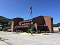
The Charles W. "Bill" Rosenau Municipal Building in 2021.
-
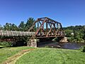
A former rail bridge over Shavers Fork in 2021, now part of the West Virginia Allegheny Trail.


See also
 In Spanish: Parsons (Virginia Occidental) para niños
