Payette County, Idaho facts for kids
Quick facts for kids
Payette County
|
||
|---|---|---|

|
||
|
||

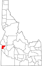
Location within the U.S. state of Idaho
|
||
 Idaho's location within the U.S. |
||
| Country | ||
| State | ||
| Founded | February 28, 1917 | |
| Named for | Francois Payette | |
| Seat | Payette | |
| Largest city | Payette | |
| Area | ||
| • Total | 410 sq mi (1,100 km2) | |
| • Land | 407 sq mi (1,050 km2) | |
| • Water | 3.4 sq mi (9 km2) 0.65% | |
| Population
(2020)
|
||
| • Total | 25,386 | |
| • Density | 61.9/sq mi (23.91/km2) | |
| Time zone | UTC−7 (Mountain) | |
| • Summer (DST) | UTC−6 (MDT) | |
| Congressional district | 1st | |
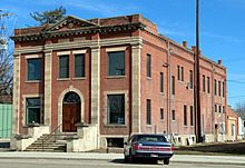
Payette County is a county located in Idaho in the United States of America. In 2020, about 25,386 people lived there. The main city and county seat is Payette.
Payette County is also part of the Ontario micropolitan area. This means it is connected to a larger town nearby for jobs and services.
Contents
History
Payette County was created in 1917. It was formed from a part of Canyon County. The county got its name from the Payette River. The river itself was named after a French-Canadian man named François Payette. He was a fur trapper, someone who hunted animals for their fur. François Payette was the first white person to explore this area in 1818.
Did you know Payette County is special? It's one of the few places in Idaho where you can find the endangered Idaho ground squirrel. This means these little animals need our help to survive!
Geography
Payette County covers about 410 square miles (1,062 square kilometers). Most of this area, about 407 square miles, is land. Only a small part, about 3.4 square miles (8.8 square kilometers), is water. This makes Payette County the smallest county in Idaho by land area.
Neighboring Counties
Payette County shares its borders with these other counties:
- Washington County (to the north)
- Gem County (to the east)
- Canyon County (to the south)
- Malheur County, Oregon (to the west)
Important Natural Areas
Part of the Deer Flat National Wildlife Refuge is located in Payette County. This refuge helps protect wildlife and their homes.
Rivers in Payette County
Two important rivers flow through the county:
Major Roads
Several main roads help people travel through Payette County:
Population Data
The number of people living in Payette County has grown over the years. Here's how the population has changed:
| Historical population | |||
|---|---|---|---|
| Census | Pop. | %± | |
| 1920 | 7,021 | — | |
| 1930 | 7,318 | 4.2% | |
| 1940 | 9,511 | 30.0% | |
| 1950 | 11,921 | 25.3% | |
| 1960 | 12,363 | 3.7% | |
| 1970 | 12,401 | 0.3% | |
| 1980 | 15,722 | 26.8% | |
| 1990 | 16,434 | 4.5% | |
| 2000 | 20,578 | 25.2% | |
| 2010 | 22,623 | 9.9% | |
| 2020 | 25,386 | 12.2% | |
| 2023 (est.) | 27,279 | 20.6% | |
| U.S. Decennial Census 1790–1960, 1900–1990, 1990–2000, 2010, |
|||
In 2010, there were 22,623 people living in Payette County. About 37% of households had children under 18. The average age of people in the county was about 37 years old.
By 2020, the population grew to 25,386 people. This shows that more families and individuals are choosing to live in Payette County.
Education
Payette County has three main school districts that serve its students:
- Fruitland School District 373
- New Plymouth School District 372
- Payette Joint School District 371
Schools in Payette Joint District 371
- Payette High School
- McCain Middle School
- Payette Primary School
- Westside Elementary School
- Payette Night School
Schools in New Plymouth District 372
- New Plymouth High School
- New Plymouth Middle School
- New Plymouth Elementary School
Schools in Fruitland District 373
- Fruitland High School
- Fruitland Middle School
- Fruitland Elementary School
- Fruitland Alternative School
Students in the area can also attend the College of Western Idaho.
Communities
Payette County has several communities where people live.
Cities
Unincorporated Community
Healthcare
The Southwest Idaho Health District provides healthcare services to the county.
See also
 In Spanish: Condado de Payette para niños
 | James Van Der Zee |
 | Alma Thomas |
 | Ellis Wilson |
 | Margaret Taylor-Burroughs |


