Payne's Down facts for kids
Quick facts for kids Payne's Down |
|
|---|---|

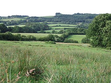
View over the upper Blackwater valley to Payne's Down.
|
|
| Highest point | |
| Elevation | 211 m (692 ft) |
| Prominence | 62 m (203 ft) |
| Parent peak | Lewesdon Hill |
| Listing | Tump |
| Geography | |
| Location | Dorset, England |
| Parent range | Marshwood & Powerstock Vales |
| OS grid | ST385012 |
| Topo map | OS Landranger 193 |
Payne's Down is a cool hill in Dorset, a county in southern England. It stands about 211 meters (that's around 692 feet) tall. You can find it about 10 kilometers east-northeast of Axminster and 1 kilometer northwest of Birdsmoorgate.
This hill is special because it rises quite a bit from the land around it. Its "prominence" is 62 meters. This means it's listed as a "Tump," which is a type of hill with a certain height and prominence. Payne's Down is part of the beautiful Dorset Downs area.
Exploring Payne's Down
The top of Payne's Down is a long, narrow ridge. It mostly has trees and stretches from the northwest to the southeast. A small road runs along its northeastern side, where you can see a few scattered houses.
Nearby Landmarks
Payne's Down is surrounded by other interesting places.
- About 3 kilometers to the southwest, you'll find Lambert's Castle. This is an ancient hill fort, which means it was once a fortified settlement on top of a hill. It stands 258 meters high.
- Across the valley of the River Synderford to the northeast is Pilsdon Pen. This is another famous hill, standing 277 meters tall.
- Further north, you can see Blackdown Hill.
Walking and Trails
If you love walking, you'll be interested to know that the Wessex Ridgeway trail passes right by the west side of Payne's Down. This long-distance path is a great way to explore the countryside.
 | Bayard Rustin |
 | Jeannette Carter |
 | Jeremiah A. Brown |

