Paynesville, Minnesota facts for kids
Quick facts for kids
Paynesville
|
|
|---|---|

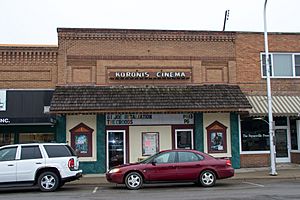
Koronis Cinema, Downtown Paynesville
|
|
| Motto(s):
"An Area For All Seasons"
|
|

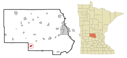
Location of Paynesville
within Stearns County, Minnesota |
|
| Country | United States |
| State | Minnesota |
| County | Stearns |
| Government | |
| • Type | Mayor–council government |
| Area | |
| • Total | 2.29 sq mi (5.93 km2) |
| • Land | 2.29 sq mi (5.93 km2) |
| • Water | 0.00 sq mi (0.00 km2) |
| Elevation | 1,175 ft (358 m) |
| Population
(2020)
|
|
| • Total | 2,388 |
| • Estimate
(2021)
|
2,449 |
| • Density | 1,042.79/sq mi (402.66/km2) |
| Time zone | UTC-6 (CST) |
| • Summer (DST) | UTC-5 (CDT) |
| ZIP code |
56362
|
| Area code(s) | 320 |
| FIPS code | 27-49966 |
| GNIS feature ID | 2396168 |
Paynesville is a city located in Stearns County, Minnesota. It sits right by Lake Koronis, which is a beautiful lake in the middle of the state. In 2020, about 2,388 people lived here. Paynesville is also part of the larger St. Cloud area.
Contents
Discovering Paynesville's Past
How Paynesville Got Its Name
Paynesville was first planned out in 1857 by a person named Edwin E. Payne. The city was named after him.
Early Challenges and Rebuilding
In 1862, during the Dakota War, everyone in Paynesville had to leave. They went to safer places like Richmond and St. Cloud. Sadly, the Dakota people burned the town down.
But the people of Paynesville didn't give up! They rebuilt their town. The U.S. Army even helped by building a wooden fence, called a stockade, around the town for protection.
The Railroad's Impact on Growth
In 1886, two big train companies, the Soo Line and Great Northern Railway, built tracks near Paynesville. This brought more people to the area.
New small towns started to form along the train lines. One was called Jim Town, and another was North Paynesville. Jim Town grew the biggest and is where downtown Paynesville is today. Eventually, all these smaller areas joined together to form "New Paynesville," which was later shortened back to just Paynesville.
Paynesville's Post Office History
A post office has been open and serving the people of Paynesville since 1857.
Paynesville's Location and Landscape
Where is Paynesville Located?
Paynesville is located along the North Fork of the Crow River. It is also right next to Lake Koronis.
Understanding Paynesville's Area
The city covers an area of about 2.32 square miles (5.93 square kilometers). All of this area is land.
Who Lives in Paynesville?
| Historical population | |||
|---|---|---|---|
| Census | Pop. | %± | |
| 1880 | 127 | — | |
| 1890 | 352 | 177.2% | |
| 1900 | 373 | 6.0% | |
| 1910 | 901 | 141.6% | |
| 1920 | 1,060 | 17.6% | |
| 1930 | 1,121 | 5.8% | |
| 1940 | 1,317 | 17.5% | |
| 1950 | 1,503 | 14.1% | |
| 1960 | 1,754 | 16.7% | |
| 1970 | 1,920 | 9.5% | |
| 1980 | 2,140 | 11.5% | |
| 1990 | 2,275 | 6.3% | |
| 2000 | 2,267 | −0.4% | |
| 2010 | 2,432 | 7.3% | |
| 2020 | 2,388 | −1.8% | |
| 2021 (est.) | 2,449 | 0.7% | |
| U.S. Decennial Census 2020 Census |
|||
Population in 2010
In 2010, there were 2,432 people living in Paynesville. These people made up 1,065 households, with 635 of them being families.
The city had about 1,048 people per square mile. There were also 1,148 housing units, like houses and apartments.
Diversity in Paynesville
Most of the people in Paynesville in 2010 were White (97.0%). A small number were African American (0.5%), Native American (0.1%), or Asian (0.4%). About 0.9% were from other backgrounds, and 1.1% were from two or more backgrounds. About 2.2% of the population was Hispanic or Latino.
Households and Families
Out of all the households, 26.9% had children under 18 living with them. Nearly half (46.9%) were married couples. Some households had a female head (7.1%) or a male head (5.6%) without a spouse. About 40.4% were not families.
Many households (35.8%) had only one person living in them. And 20.4% of households had someone aged 65 or older living alone. The average household had 2.20 people, and the average family had 2.83 people.
Age of Residents
The average age in Paynesville was 42.4 years old.
- 22.1% of residents were under 18.
- 6.9% were between 18 and 24.
- 23.6% were between 25 and 44.
- 21.9% were between 45 and 64.
- 25.3% were 65 years or older.
There were slightly more females (52.3%) than males (47.7%) in the city.
Getting Around Paynesville
Main Roads and Highways
Three important state highways run through Paynesville: Highway 4, Highway 23, and Highway 55. These roads help people travel in and out of the city.
Train Services
The Soo Line train company still provides freight (cargo) train service to Paynesville. In the past, you could also catch a passenger train from the Great Northern Railway or the Soo Line's Winnipeger. But passenger train service stopped in 1970. Now, the closest train station for passengers is in St. Cloud.
Paynesville's Airport
The City of Paynesville has its own small airport called Paynesville Municipal Airport (PEX/KPEX). It's used for general aviation, which means smaller private planes.
Exploring Paynesville's Lakes
Lake Koronis: A Fishing Hotspot
Just one mile south of Paynesville is Lake Koronis. This large lake covers 3,014 acres. It's known for having some of the best fishing in the area! You can find lots of walleye, bass, and northern pike here.
The lake is quite deep, reaching up to 132 feet. On average, it's about 29 feet deep. However, the lake does have some unwanted plants and animals, like starry stonewort and zebra mussels, which are invasive species.
Rice Lake: Another Great Fishing Spot
About five miles southeast of Paynesville is Rice Lake. This lake is also big, covering 1,639 acres. It's another excellent place for fishing walleye, bass, and northern pike.
You can get to Rice Lake from two public access points. One is on the northwest side, at the end of 180th Street. The other is on the southwest side, at the end of 253rd Avenue.
Images for kids
See also
 In Spanish: Paynesville (Minnesota) para niños
 | Georgia Louise Harris Brown |
 | Julian Abele |
 | Norma Merrick Sklarek |
 | William Sidney Pittman |


