
Peleliu facts for kids
Quick facts for kids
Peleliu
|
||
|---|---|---|
|
State
|
||

Orange beach, Peleliu
|
||
|
||

Location of Peleliu in Palau
|
||
| Country | ||
| Capital | Kloulklubed | |
| Area | ||
| • Total | 13 km2 (5 sq mi) | |
| Population
(2015)
|
||
| • Total | 484 | |
| • Density | 37.2/km2 (96/sq mi) | |
| ISO 3166 code | PW-228 | |

Peleliu (also called Beliliou) is an island in the country of Palau. It is one of the sixteen states of Palau. Peleliu and two smaller islands nearby make up this state. The island is famous for the Battle of Peleliu that happened here during World War II.
Contents
History of Peleliu Island
Early European Visits
The first Europeans to see Peleliu were from a Spanish trip led by Ruy López de Villalobos in January 1543. They called the islands "The Reefs." Later, in 1710, a Spanish missionary group explored these islands more. Another Spanish officer, Bernardo de Egoy, explored them in detail two years later.
Changing Control of the Island
After losing the Spanish–American War, Spain sold Palau, including Peleliu, to Germany in 1899. Then, in 1914, control of the island passed to Japan.
Peleliu in World War II
During World War II, Peleliu was the site of a very important and fierce battle. It was fought between the United States Marine Corps and United States Army against the Imperial Japanese Army. The Japanese military had built strong defenses in the island's caves and rocks. This made the battle very hard for the attacking forces.
Both sides had many losses. More than 2,000 Americans and 10,000 Japanese soldiers died. Luckily, no local people were hurt. They were moved to other islands in Palau before the fighting started.
After the Battle
Today, you can still see the remains of many military buildings from the war. The old airstrip is still there. You can also see shipwrecks underwater near the coast. There are memorials on the island for both American and Japanese soldiers who died.
Peleliu and Angaur were the only islands in Palau that the Americans took over during the war. The capital city of Koror stayed under Japanese control until the war ended.
Modern History and Independence
In 1947, the United States took control of Peleliu under the United Nations. This was part of the Trust Territory of the Pacific Islands. Palau became an independent country in 1978. Peleliu then became one of the states within the new country. In 2014, Peleliu hosted a big meeting for leaders from 15 Pacific island nations.
Geography of Peleliu


Peleliu is about 10 kilometers (6 miles) northeast of Angaur island. It is also about 40 kilometers (25 miles) southwest of Koror island. The total area of Peleliu is about 13 square kilometers (5 square miles).
In 2000, about 571 people lived on Peleliu. This made it the third most populated state in Palau. Most people live in the village of Kloulklubed. This village is the state's capital and is on the northwestern coast.
Villages of Peleliu
Peleliu has four main villages:
- Kloulklubed (in the northwest)
- Imelechol (in the northeast)
- Lademisang (in the central southern part)
- Ongeuidel (in the northernmost part)
Government and Politics
Peleliu state has a small population, less than 500 people. It has an elected chief leader called a governor. The state also has a group of lawmakers who are elected every three years. The people of Peleliu also elect one person to represent them in the House of Delegates of Palau.
Island Infrastructure
Peleliu Airfield
Peleliu Airfield was built by the Japanese during World War II. It has the longest and widest runway in Palau, measuring 1,850 meters (6,070 feet). However, it is now only used by small private planes. Domestic flights within Palau stopped in late 2005.
Transportation and Harbor
A boat service connects Peleliu to Koror and Angaur twice a week. The boat ride from Koror takes over an hour. The small harbor in the far north of the island is not very deep. It is only suitable for small boats like yachts.
Peleliu Battlefield as a Landmark
|
Peleliu Battlefield
|
|
| Location | Peleliu, Palau |
|---|---|
| Area | 7,680 acres (3,110 ha) |
| Built | 1944 |
| NRHP reference No. | 85001754 |
| Added to NRHP | February 4, 1985 |
The entire island of Peleliu is recognized as a special historical site. It is called the Peleliu Battlefield and is listed on the National Register of Historic Places. It has also been named a U.S. National Historic Landmark.
Education on Peleliu
The Ministry of Education runs the public schools in Palau.
Peleliu Elementary School first opened in 1946. A second building for the school was opened in 1966, but the first building is still used today.
Palau High School in Koror is the only public high school in the country. This means that children from Peleliu go there for their high school education.
Images for kids
-
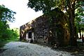
Peleliu World War II Memorial Museum
-
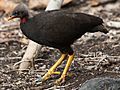
Both IBAs are important for Micronesian megapodes
-
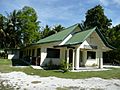
A church in the state of Peleliu


See also
 In Spanish: Estado de Peleliu para niños
