Pelly River facts for kids
Quick facts for kids Pelly River (Ts'enkínyäk Chú) |
|
|---|---|

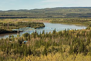
Pelly River at Pelly Crossing
|
|

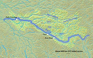
Map of the Pelly River
|
|
| Country | Canada |
| Territory | Yukon |
| Cities |
|
| Physical characteristics | |
| Main source | Mackenzie Mountains An unnamed glacier 1,465 m (4,806 ft) 62°26′32″N 129°11′34″W / 62.44222°N 129.19278°W |
| River mouth | Yukon River 458 m (1,503 ft) 62°46′44″N 137°20′16″W / 62.77889°N 137.33778°W |
| Length | 530 km (330 mi), East-southeast to west-northwest |
| Basin features | |
| Basin size | 49,000 km2 (19,000 sq mi) |
| Tributaries |
|
The Pelly River (Ts'ekínyäk Chú) is a long river in Canada. It's one of the main rivers that flows into the famous Yukon River. The Pelly River starts in the western part of the Mackenzie Mountains. It then travels about 530 km (330 mi) through the central part of the Yukon territory. Along its journey, it picks up water from two important smaller rivers, called tributaries: the Ross River and the Macmillan River.
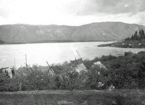
The Selkirk First Nation (also known as the Hucha Hudan people) have their own name for the river: Ts'enkínyäk Chú. This name means 'water running between the mountains'. Later, a fur trader named Robert Campbell named the river "Pelly" to honor Sir John Henry Pelly. Sir John Pelly was in charge of the Hudson's Bay Company, a very old trading company. You can still visit the old Hudson's Bay Company trading post called Fort Selkirk. It's located right where the Pelly River joins the Yukon River.
Contents
Where the Pelly River Flows
The Pelly River begins high up in the Selwyn Mountains. It starts from glaciers, which are like huge, slow-moving rivers of ice. These glaciers are more than 1,400 m (4,600 ft) high, close to the border between the Yukon and the Northwest Territories.
First, the river flows south and then west through a wide valley. Many small streams join it from the east. It passes by the Pelly Lakes, and then the Woodside River flows out of these lakes. After this, the Pelly River turns west again.
Journey Through the Tintina Trench
The Pelly River then takes a northwesterly path through a long, narrow valley called the Tintina Trench. It flows northwest until it meets the Ross River near the town of Ross River. In Ross River, there's a special cable ferry that helps people cross the river.
The Pelly River then flows alongside the Robert Campbell Highway. It's joined by the Lapie River from the left side. The river then passes the community of Faro, where you can cross it using a bridge. After Faro, the river runs south of Rose Mountain and the Glenlyon River adds its waters to the Pelly.
Canyons and Plains
Where the Glenlyon River joins, the valley gets narrower, and the hillsides become taller and steeper. A short distance later, the fast-flowing Tay River joins from the right. A few kilometers after that, the Pelly River turns north and the Earn River also joins it from the right.
Soon, the river leaves the narrow canyon and flows across a flat plain. Here, the Tummel River joins from the left. Then, the Macmillan River, which is the Pelly's biggest tributary, flows in from the right. The Pelly River then turns west, making a loop around the town of Pelly Crossing. It goes under the Klondike Highway here. This is one of only two bridges that cross the Pelly River (the other is in Faro). The river continues west for about 25 km (16 mi) until it meets the Yukon River near the old Fort Selkirk.
The Pelly River's Watershed
The Pelly River is one of the two main starting points for the Yukon River. The other is the Stewart River. The area of land that drains water into the Pelly River, called its drainage basin or watershed, is huge! It covers about 49,000 km2 (19,000 sq mi) of land. This includes a big part of the Yukon Plateau, which is a large, mostly empty area in central Yukon, west of the Mackenzie Mountains.
The Tintina Trench, where most of the Pelly River flows, is the northern end of an even bigger valley system called the Rocky Mountain Trench. This huge trench stretches far south into British Columbia.
River Travel and Water Flow
Small and medium-sized boats can travel on the Pelly River for more than 320 km (200 mi). This is from its mouth all the way up to a spot called Hoole Rapids. However, there's a shallow part in Bradens Canyon that can be tricky for boats.
The towns of Ross River, Faro, and Pelly Crossing are all located along the Pelly River. As mentioned, there are bridges in Pelly Crossing (on the Klondike Highway) and Faro. There's also a cable ferry at Ross River on the Canol Road.
The Pelly River's average water flow, or discharge, is about 700 m3/s (25,000 cu ft/s). This means a lot of water moves through it every second! The river gets most of its water from melting glaciers. Because of this, the most water flows in June or July, reaching up to 1,600 m3/s (57,000 cu ft/s). The least amount of water flows in December or January, sometimes as low as 35 m3/s (1,200 cu ft/s).
Natural Features Near the Pelly River
Sometimes, natural events can affect the Pelly River. For example, volcanoes like Volcano Mountain are found near the river. In the past, these volcanoes might have changed the river's path or partly blocked it. Scientists study these areas to understand how natural events can shape the land and rivers.
See also
 In Spanish: Río Pelly para niños
 | Calvin Brent |
 | Walter T. Bailey |
 | Martha Cassell Thompson |
 | Alberta Jeannette Cassell |


