
Penguin Peak facts for kids
Quick facts for kids Penguin Peak |
|
|---|---|
.jpg)
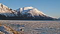
Penguin Peak seen from Bird Ridge
|
|
| Highest point | |
| Elevation | 4,331 ft (1,320 m) |
| Prominence | 1,437 ft (438 m) |
| Geography | |

Penguin Peak
Location in Alaska
|
|
| Location | Chugach National Forest Anchorage Municipality, Alaska United States |
| Parent range | Chugach Mountains |
| Topo map | USGS Seward D-7 |
| Climbing | |
| Easiest route | Hiking class 2 |
Penguin Peak is a cool mountain in Alaska, standing tall at about 4,331 feet (1,320 meters) high! It's part of the amazing Chugach Mountains range. You can find it in the Anchorage area, inside the beautiful Chugach State Park.
This peak is about 30 miles (48 km) southeast of downtown Anchorage. It's also about 8 miles (13 km) east of the Alyeska Resort and Girdwood area. Penguin Peak is a really noticeable landmark if you're driving along the Seward Highway next to Turnagain Arm. From its top, you get a great view of Mount Alpenglow, which is about 6 miles (10 km) away across Turnagain Arm.
Contents
Discover the Climate Around Penguin Peak
Penguin Peak is located in a subarctic climate zone. This means the area has very cold and snowy winters. Summers are usually mild, not too hot.
How Weather Affects the Peak
Weather systems often come from the Gulf of Alaska. When they reach the Chugach Mountains, the mountains force the air upwards. This process is called orographic lift. It causes a lot of rain and snow to fall on the mountains.
Winter Conditions
During winter, temperatures can drop below -20 °C (-4 °F). With the wind chill, it can feel even colder, sometimes below -30 °C (-22 °F). The snow and rain that fall on the mountain eventually drain into Penguin Creek and Turnagain Arm.
Images for kids
-
Penguin Peak seen from Seward Highway
-
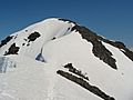
Summit detail
-
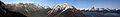
Panorama from Bird Ridge with Penguin Peak centered


