
Perchas, Morovis, Puerto Rico facts for kids
Quick facts for kids
Perchas
|
|
|---|---|
|
Barrio
|
|

Homes perched on mountainside in Perchas on PR-155 near Km 35.5
|
|

Location of Perchas within the municipality of Morovis shown in red
|
|

Perchas, Morovis, Puerto Rico
Location in Caribbean
|
|
| Commonwealth | |
| Municipality | |
| Area | |
| • Total | 2.71 sq mi (7.0 km2) |
| • Land | 2.71 sq mi (7.0 km2) |
| • Water | 0 sq mi (0 km2) |
| Elevation | 1,273 ft (388 m) |
| Population
(2010)
|
|
| • Total | 1,336 |
| • Density | 493/sq mi (190/km2) |
| Source: 2010 Census | |
| Time zone | UTC−4 (AST) |
| Zip code |
00687
|
| Area code(s) | 787 |
Perchas is a small community, also known as a barrio, located in the town of Morovis, Puerto Rico. In 2010, about 1,336 people lived here. Perchas has 11 smaller areas called sectors. You can travel from Perchas to the nearby town of Orocovis using Puerto Rico Highway 155.
Contents
History of Perchas
Early History and Census Data
After the Spanish–American War, Spain gave Puerto Rico to the United States in 1898. This happened under the Treaty of Paris of 1898. Puerto Rico then became a territory of the United States.
In 1899, the United States government counted the people in Puerto Rico. This count is called a census. The census found that 1,124 people lived in the Perchas barrio at that time.
| Historical population | |||
|---|---|---|---|
| Census | Pop. | %± | |
| 1900 | 1,124 | — | |
| 1980 | 942 | — | |
| 1990 | 1,343 | 42.6% | |
| 2000 | 1,354 | 0.8% | |
| 2010 | 1,336 | −1.3% | |
| U.S. Decennial Census 1899 (shown as 1900) 1910-1930 1930-1950 1980-2000 2010 |
|||
Hurricane Maria's Impact
On September 20, 2017, Hurricane Maria hit Puerto Rico. This powerful storm caused a large landslide in Perchas. A huge rock ended up hanging dangerously over Puerto Rico Highway 155. This rock was a threat to homes, buildings, and people driving on the road.
About six months later, experts used a controlled explosion to break apart the huge rock. This made the area safe again. After the hurricane, many roads were blocked by dirt and damaged buildings. People from nearby communities had to travel through Perchas to reach the main town of Morovis.
Sectors of Perchas
Barrios like Perchas are often divided into smaller areas. These smaller areas are called sectores in Spanish, which means sectors in English. The types of sectors can be different. Some are simply called sector, while others might be named urbanización (urbanization) or reparto (development).
Here are the sectors located in Perchas barrio:
- Sector Adrovet
- Sector Arraijanes
- Sector El Castillo
- Sector El Zapato
- Sector Los Naranjos
- Sector Los Santos
- Sector Perchas Díaz
- Sector Perchas Quirós
- Sector Perchas
- Sector El Radar
- Tramo Carretera 155 (which means a section of Highway 155)
Gallery
-
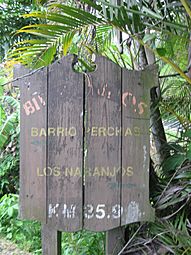
Sign in Perchas, Puerto Rico Highway 155, Km 35.9

See also
 In Spanish: Perchas (Morovis) para niños
- List of communities in Puerto Rico
