Pine Junction, Colorado facts for kids
Quick facts for kids
Pine Junction, Colorado
|
|
|---|---|
|
Town
|
|

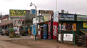
Commercial area along US 285 in Pine Junction
|
|
| Country | |
| State | |
| Counties | Park, Jefferson |
| Elevation | 8,448 ft (2,575 m) |
| Time zone | UTC-7 (MST) |
| • Summer (DST) | UTC-6 (MDT) |
| Highways | |
Pine Junction is a small community in central Colorado, United States. It's not officially a town, but it's a known place. This area is special because it's the first spot on U.S. Highway 285 in the mountains that has a traffic light.
From this traffic light, you can turn onto Colorado Road 126. This road leads to the historic Town of Pine Grove. You can also continue to State Highway 67 to reach places like Deckers and Woodland Park.
Contents
Discover Pine Junction
Pine Junction is located in the foothills of the Front Range mountains. It sits south of Mount Blue Sky. This community is about 25 miles (40 km) southwest of Denver. It is right along U.S. Highway 285.
Where is Pine Junction Located?
The community is split between two counties: Park County and Jefferson County. It's at the top of a hill on the highway. East of Pine Junction, the highway goes down into the Platte Canyon near Bailey.
What Can You Find Here?
Pine Junction has many businesses along the highway. There are also homes nearby on both sides of the road. Many people who live here travel to the Denver Metropolitan Area for work. This makes Pine Junction a "bedroom community." You can also find a hardware store and storage rentals here.
Getting Around with Bustang
Pine Junction is part of Colorado's Bustang network. This is a public bus service that connects different parts of the state. Pine Junction is a stop on the Gunnison-Denver Outrider line. This means you can catch a bus here to travel to Gunnison or Denver.
 | Sharif Bey |
 | Hale Woodruff |
 | Richmond Barthé |
 | Purvis Young |


