Pine Valley (Beaver, Millard, Iron counties, Utah) facts for kids
for other uses, see Pine Valley (disambiguation)
Quick facts for kids Pine Valley |
|
|---|---|

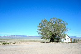
North Pine Valley and the Wah Wah Mountains, May 2010
|
|
| Length | 50 mi (80 km) N-S |
| Width | 13 mi (21 km) |
| Geography | |
| Country | United States |
| State | Utah |
| Region | Great Basin Desert |
| Counties | Beaver, Millard and Iron |
| Communities | Five Points |
| Borders on |
List
|
| River | Pine Valley Wash |
Pine Valley is a long valley in southwestern Utah, United States. It stretches for about 50 miles (80 km). Most of this valley is in western Beaver and Millard counties. A small part of the southern valley reaches into Iron County.
The valley is a "closed basin," which means water flows into it but doesn't flow out to the ocean. Instead, the water from Pine Valley Wash flows north and sinks into the ground. About 7 miles (11 km) north of where the water sinks, there's a flat, hard area called the Pine Valley Hardpan. It's about 4 miles (6.4 km) long from east to west.
In the northwest part of Pine Valley, there's a 12-mile (19 km) long Desert Biosphere Reserve and Experimental Station. This special area helps protect desert plants and animals and is used for scientific studies. The southern part of the Tunnel Springs Mountains is also within this experimental station.
Exploring Pine Valley's Geography
Pine Valley is about 50 miles (80 km) long. The valley gets narrower in the south, becoming about 3 miles (4.8 km) wide. This is where the Pine Valley Wash begins. The valley mostly runs north to south. However, the southern 10 miles (16 km) turn southeast. This part runs next to a mountain ridge called the Indian Springs Range.
The very end of Pine Valley in the south is where the Indian Springs and Wah Wah Mountains meet. To the west, you'll find Steamboat Mountain. A series of peaks and hills form the southern edge of these two mountain ranges. This mountainous area also forms part of the northwest border of the Escalante Desert, which is a lower area.
The northern end of Pine Valley also gets narrower. Here, the Tunnel Springs Mountains form the western border. A lower stretch of mountains and hills extends northwest from the northern Wah Wah Mountains, creating the eastern border.
Water Features and Landforms
In the middle of Pine Valley, there's a 7-mile (11 km) long alluvial fan. This is a fan-shaped deposit of sand and gravel carried by water, which spreads out from the side of the Mountain Home Range.
The center of the valley has CCC Reservoir, a water storage area. Further north, you'll find Cow Camp Well and Electric Fence Reservoir. These are located in the "sinks region," where the Pine Valley Wash ends. Just north of this area is the Pine Valley Hardpan. Many washes, or dry streambeds, feed into the hardpan from different directions. The lowest point of the valley is likely the Pine Valley Hardpan or the Pine Valley Wash sinks.
Getting Around Pine Valley
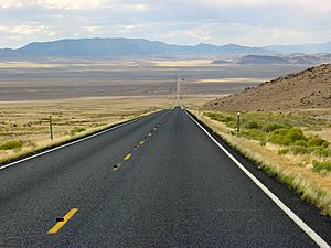
A paved road called Pine Valley Road runs from the southern end of Pine Valley to its north-central part. It passes east of Five Points. This road starts near Lund, which is south of the Wah Wah Mountains and in the Escalante Desert.
The paved section of Pine Valley Road ends where it meets Utah State Route 21 (SR-21). From there, a local road continues north. This straight road runs along the eastern edge of the Desert Biosphere Reserve and Experimental Station. It also crosses the eastern side of the small Tunnel Springs Mountains. This road eventually ends further north at U.S. Route 6 and U.S. Route 50. Part of the Pine Valley Hardpan is also crossed by Pine Valley Road.
State Route 21 travels northwest from Garrison and crosses the central-northern part of Pine Valley. This route goes east to Milford, which is about 40 miles (64 km) away. Many unpaved roads also provide access to the surrounding mountain foothills and various canyons or washes.
 | John T. Biggers |
 | Thomas Blackshear |
 | Mark Bradford |
 | Beverly Buchanan |


