Pinnacle Creek facts for kids
Quick facts for kids Pinnacle Creek |
|
|---|---|

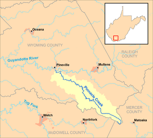
Pinnacle Creek and its watershed in Wyoming County, West Virginia.
|
|
| Country | United States |
| State | West Virginia |
| County | Wyoming |
| Physical characteristics | |
| Main source | east of Crumpler 3,285 ft (1,001 m) 37°25′21″N 81°18′10″W / 37.4226158°N 81.3028786°W |
| River mouth | Guyandotte River Pineville 1,289 ft (393 m) 37°34′29″N 81°32′12″W / 37.5748351°N 81.5367722°W |
| Length | 26.6 mi (42.8 km) |
| Basin features | |
| Basin size | 57.23 sq mi (148.2 km2) |
Pinnacle Creek is a stream in southern West Virginia, United States. It is about 26.6 miles (42.8 km) long. This creek is a tributary of the Guyandotte River. A tributary is a smaller stream that flows into a larger river.
Pinnacle Creek is part of a huge water system. Its waters eventually flow into the Ohio River and then the mighty Mississippi River. This entire area, where all the water drains into one river system, is called a watershed. Pinnacle Creek's watershed covers about 57.23 square miles (148.2 km2). This area is mostly rural and sits on a part of the Allegheny Plateau that was not covered by glaciers long ago.
Where Pinnacle Creek Flows
Pinnacle Creek is entirely located within Wyoming County. It starts in the very southeastern part of the county. This spot is close to where Wyoming, McDowell, and Mercer counties meet.
Source and Journey
The creek begins about 2 miles (3.2 km) east of a place called Crumpler. From there, it flows generally towards the northwest. Its journey ends when it reaches the southern edge of the town of Pineville. Here, Pinnacle Creek joins the Guyandotte River.
Land Around the Creek
The United States Geological Survey collected information about the land around Pinnacle Creek in 1992. Their findings show how the land in the creek's watershed was being used.
- Forests: About 96% of the land was covered by forests. This means lots of trees and natural habitats.
- Farms: Around 1% of the land was used for farming.
- Businesses and Mining: About 2% of the land was used for businesses or mining activities.
This information helps us understand the environment and how people interact with the land around Pinnacle Creek.
 | Madam C. J. Walker |
 | Janet Emerson Bashen |
 | Annie Turnbo Malone |
 | Maggie L. Walker |

