
Plunketts Creek (Loyalsock Creek tributary) facts for kids
Quick facts for kids Plunketts Creek |
|
|---|---|

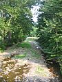
Plunketts Creek looking upstream, just north of the mouth in Plunketts Creek Township
|
|

Map of Plunketts Creek showing named tributaries and settlements along the creek
|
|

Location of the mouth of Plunketts Creek in Lycoming County, Pennsylvania
|
|
| Country | United States |
| State | Pennsylvania |
| Counties | Lycoming, Sullivan |
| Physical characteristics | |
| Main source | Loyalsock State Forest Near Hillsgrove, Hillsgrove Township, Sullivan County, Pennsylvania 1,440 ft (440 m) 41°26′41″N 76°44′48″W / 41.44472°N 76.74667°W |
| River mouth | Loyalsock Creek Barbours, Plunketts Creek Township, Lycoming County, Pennsylvania 725 ft (221 m) 41°23′55″N 76°47′45″W / 41.39861°N 76.79583°W |
| Length | 6.2 mi (10.0 km) |
| Basin features | |
| Basin size | 23.6 sq mi (61 km2) |
Plunketts Creek is a small stream in Pennsylvania. It flows for about 6.2 miles (10 km). This creek is a branch of Loyalsock Creek. It runs through parts of Lycoming and Sullivan counties.
The creek's water eventually reaches the Chesapeake Bay. It flows into the West Branch Susquehanna and then the Susquehanna River. The area around the creek, called its watershed, covers about 23.6 square miles (61 km²).
Plunketts Creek is named after the first person who owned the land near its end. The creek flows through a hilly area called the Allegheny Plateau. This region has rocks from ancient geological times. Today, the Plunketts Creek area is mostly covered in forests. It is known for its clean water and great outdoor activities. These include fishing and hiking.
Contents
What's in a Name?
Plunketts Creek gets its name from Colonel William Plunkett. He was a doctor and a judge in the 1700s. Plunkett received a large piece of land in 1776. This land included the spot where the creek flows into Loyalsock Creek. That's how the creek got its name.
During the American Revolution, some people thought Plunkett supported the British. He died in 1791. Later, a new area was formed in 1838. People wanted to name it "Plunkett Township." But because of the old suspicions, they named it Plunketts Creek Township instead. This was a way to honor the creek, not just the person.
The township was once much bigger. Over time, parts of it became other townships. In 1847, Sullivan County was created. This split Plunketts Creek Township into two parts. One part was in Lycoming County, and the other in Sullivan County. To avoid confusion, the Sullivan County part changed its name to Hillsgrove Township in 1856.
Even though Colonel Plunkett spelled his name "Plunket," the creek's name has an "s" at the end. It is the only stream officially called "Plunketts Creek" in the United States.
The Creek's Journey
Plunketts Creek starts high up, about 1,440 feet (439 m) above sea level. Its source is a pond in Loyalsock State Forest. The creek flows southwest, crossing a road twice. It then enters Lycoming County.

As it flows, Plunketts Creek picks up water from other smaller streams. These include Reibsan Run, Mock Creek, and Wolf Run. Near the village of Proctor, it gets King Run. Then, the creek turns south.
It flows through the Pennsylvania Game Commission's Northcentral Game Farm. This farm raises pheasants. Finally, Plunketts Creek reaches the village of Barbours. Here, it joins the larger Loyalsock Creek. The mouth of the creek is at 725 feet (221 m) above sea level.
The creek is 6.2 miles (10 km) long. But the straight-line distance from its start to its end is only 4.1 miles (6.6 km). This shows how winding the creek is. The creek drops 715 feet (218 m) from its source to its mouth. This makes it a fast-flowing stream.
When the Creek Floods
The water level in Plunketts Creek can change a lot. It's usually deepest in spring or after heavy rain. In late summer, it can become a tiny trickle. There isn't a special gauge just for Plunketts Creek. But you can get an idea from the Loyalsock Creek gauge nearby.

In September 2011, a big flood happened. It was caused by heavy rain from Tropical Storm Lee. The flood damaged homes and roads in Proctor and Barbours. It even destroyed a small bridge. The Barbours Fire Hall became a place for people to get help.
Another big flood happened in January 1996. This flood also caused a lot of damage. It destroyed an old stone arch bridge on Plunketts Creek. The water was 4 feet (1.2 m) deep in Barbours. People called it the worst flood the village had ever seen.
The Land Around the Creek
Plunketts Creek is in a hilly area called the Allegheny Plateau. The rocks under the ground are mostly sandstone and shale. These rocks formed millions of years ago. The northern part of the creek's area has older rocks.

There isn't much coal in the Plunketts Creek area. But long ago, a small coal mine operated there. You can even find a stream called "Coal Mine Hollow." The valley of Plunketts Creek has many deposits from ancient glaciers. These include sand and gravel.
The Plunketts Creek Watershed
The Plunketts Creek watershed is the area of land where all the water flows into the creek. It covers about 23.6 square miles (61 km²). Most of this area is in Plunketts Creek Township.

Several smaller streams flow into Plunketts Creek. The biggest one is Wolf Run. It makes up about 31% of the watershed. King Run is the next largest, making up 23.6%. These smaller streams are important for the creek's water supply.
Water Quality and Fish
Long ago, cutting down all the trees and having factories hurt the creek's water. There was a coal mine and a tannery (a place that makes leather). These industries caused pollution. In the late 1800s, some people working at the tannery even got sick.
Today, the water quality is much better. Plunketts Creek and some of its branches are known as "High Quality-Cold Water Fisheries." This means they are great places for fish that like cold, clean water. Some parts are even called "Exceptional Value" streams.
= Fun Activities
People have always loved fishing for trout in Plunketts Creek. The Pennsylvania Fish and Boat Commission says that Engle Run and Noon Branch are "Class A Wild Trout Waters." This means they have many naturally raised trout.
The forests around Plunketts Creek are also popular for hunting. People hunt for black bear, white-tailed deer, and wild turkey. You can hunt, trap, and fish in the Loyalsock State Forest and Pennsylvania State Game Lands No. 134.
Besides hunting and fishing, you can also enjoy other outdoor activities. These include camping, hiking, mountain biking, and snowmobiling. There's even a long hiking trail called the Old Loggers Path that goes through the watershed.
A Look Back in Time
Early Settlers
The first people known to live in this area were Native Americans. They were called the Susquehannocks. Later, the Lenape tribe lived here. In 1768, the British bought this land from the Iroquois. This opened the area for new settlers.
William Plunkett received land here in 1776. It's not clear if he ever lived on his land. The first recorded settler in what became Plunketts Creek Township was a man named Paulhamus. He lived there sometime between 1770 and 1776.
Lumber and Leather
Like many streams in Pennsylvania, Plunketts Creek was a place for settlers to build homes and mills. The first village on the creek was Barbours. It was founded in 1832 by John S. Barbour, who built a sawmill. Barbours became a busy lumber town.

In 1868, the village of Proctor was built. It was a "company town" for a large tannery. The tannery made leather for shoes. It employed hundreds of people. They lived in company houses. Hemlock bark, used for tanning, was brought from miles away. The hides came from all over the world.
Plunketts Creek also provided power for mills. There were sawmills, woolen mills, and grain mills. By 1892, there were two steam-powered sawmills on the creek. Railroads were also built to transport lumber.
Changes Over Time
The lumber boom ended when all the old trees were cut down. By 1898, the tannery in Proctor closed. The last logs were floated down Plunketts Creek in 1905. The railroads built for lumber were abandoned. Without the timber industry, the populations of Proctor and Barbours shrank.

Over time, new forests grew back. The state started buying land to create state forests and game lands. In 1945, the Northcentral State Game Farm was built on Plunketts Creek. It raises pheasants for hunting.
Today, much of the Plunketts Creek watershed is protected. It's part of Loyalsock State Forest or Pennsylvania State Game Lands No. 134. Small-scale lumbering still happens. Barbours still has one sawmill.

The area is still a popular place for tourists. Many people have cabins there. More and more people are choosing to live there year-round. The opening of trout season brings many visitors to the creek.
Images for kids
-
Plunketts Creek can shrink to a trickle in late summer.

