Port Alma, Queensland facts for kids
Quick facts for kids Port AlmaQueensland |
|||||||||||||||
|---|---|---|---|---|---|---|---|---|---|---|---|---|---|---|---|

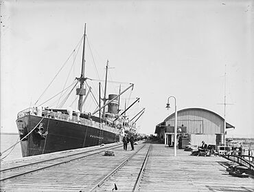
Ship "Roscommon" moored at Port Alma
|
|||||||||||||||
| Population | 0 (2021 census) | ||||||||||||||
| • Density | 0/km2 (0/sq mi) | ||||||||||||||
| Postcode(s) | 4699 | ||||||||||||||
| Area | 312.8 km2 (120.8 sq mi) | ||||||||||||||
| Time zone | AEST (UTC+10:00) | ||||||||||||||
| Location |
|
||||||||||||||
| LGA(s) | Rockhampton Region | ||||||||||||||
| State electorate(s) | Mirani | ||||||||||||||
| Federal Division(s) | Flynn | ||||||||||||||
|
|||||||||||||||
Port Alma is a coastal town and port in the Rockhampton Region of Queensland, Australia. It is also a locality, which is like a small area or district. In 2021, Port Alma had a very small population, almost no people living there.
Contents
Exploring Port Alma's Geography
Port Alma is about 60 kilometers (37 miles) from Rockhampton. It sits at the southern end of the Fitzroy River delta. A delta is a landform that forms at the mouth of a river. It is made of sediment that the river carries downstream.
The area is bordered by the Fitzroy River to the north. To the northeast is Keppel Bay. Raglan Creek forms the eastern and southeastern borders. The town itself is on the western bank of Raglan Creek.
Much of Port Alma is low-lying marshland. This means it's often wet and undeveloped. There is one small hill called Sandfly Hillock. It is on Casuarina Island and rises to 12 meters (39 feet) above sea level.
Islands and Waterways
The Fitzroy River delta creates many low-lying islands and channels. These are formed by Casuarina Creek and other small creeks. Some of these islands and waterways include:
- Alligator Passage
- Casuarina Island
- Dunlop Island
- Egg Sand (a marine bank)
- Jacks Island
- Mosquito Island
- Pugh Sand (a sand bar)
- Sandfly Island
- Satellite Channel
Coastal Points
Port Alma's coastline has several headlands, which are pieces of land that stick out into the sea. Some of these points are:
- Bunyip Point
- Eupatoria Point
- False Point
- Gayden Point
- Iguana Point
- Pile Point
- Rocky Point
- Saurian Point
- Shell Point
- Woods Point
A Look at Port Alma's History
The town of Port Alma was named in 1864. It was named by Commander J. Jeffrey, a hydrographer. He named it after a battle site from the Crimean War.
A railway line, called the Port Alma railway line, was built in 1912. It was 26 kilometers (16 miles) long. This line connected the port at Port Alma to Bajool railway station. This helped people and goods travel from Rockhampton to the port.
The last part of the railway line closed in 1986. The rest of the line was used by a salt works until 1990. There were two railway stations on this line, but they are no longer there:
- CQ Salt railway station
- Port Alma railway station
Population Details
Port Alma has a very small population. In both the 2016 and 2021 censuses, it was recorded as having "no people or a very low population." This means very few, if any, people live there permanently.
Port Alma's Economy
The economy in Port Alma mainly focuses on two things: making salt and operating a cargo port.
Salt is produced in large evaporation pans in the area. This region is the main supplier of salt in Queensland. It also exports salt to other places. The salt is used for many things. These include food, swimming pools, and different industrial processes.
The port in Port Alma handles various types of cargo. This includes special materials for industry and military use. It also handles bulk tallow, which is a type of animal fat.
Schooling in Port Alma
There are no schools located directly in Port Alma. Students usually attend schools in nearby towns. The closest primary schools are Bajool State School in Bajool and Marmor State School in Marmor.
For high school, students might go to Mount Larcom State School. This school teaches up to Year 10. Another option is Rockhampton State High School in Wandal, Rockhampton.
Local Facilities
Port Alma has three boat ramps for people who want to launch boats. Two of these ramps are managed by the Rockhampton Regional Council:
- Casuarina Creek boat ramp and floating walkway on Port Alma Road.
- Inkerman Creek boat ramp and floating walkway on Port Alma Road.
The third boat ramp is the Raglan Creek boat ramp. It is also on Port Alma Road. This ramp is managed by the Department of Transport and Main Roads.
 | Claudette Colvin |
 | Myrlie Evers-Williams |
 | Alberta Odell Jones |


