
Port Hedland, Western Australia facts for kids
Quick facts for kids Port HedlandWestern Australia |
|||||||||
|---|---|---|---|---|---|---|---|---|---|

Esplanade Hotel, Port Hedland, April 2023
|
|||||||||

Port Hedland
Location in Western Australia
|
|||||||||
| Population | 15,298 (2021 census) | ||||||||
| Established | 22 October 1896 | ||||||||
| Postcode(s) | 6721 | ||||||||
| Elevation | 6 m (20 ft) | ||||||||
| Time zone | AWST (UTC+8) | ||||||||
| Location | |||||||||
| LGA(s) | Town of Port Hedland | ||||||||
| State electorate(s) | Pilbara | ||||||||
| Federal Division(s) | Durack | ||||||||
|
|||||||||
Port Hedland is a busy town in the Pilbara region of Western Australia. It's the second largest town there. In 2021, about 15,298 people lived in Port Hedland and the nearby town of South Hedland, which is 18 kilometers away. Port Hedland is also home to Australia's busiest port, meaning it handles the most cargo by weight.
Contents
- What is the Economy of Port Hedland?
- What is the History of Port Hedland?
- What is the Climate of Port Hedland?
- What is the Infrastructure of Port Hedland?
- What Animals and Plants Live in Port Hedland?
- What are the Environmental Issues in Port Hedland?
- What is the Blackrock Stakes?
- Images for kids
- See also
What is the Economy of Port Hedland?
Port Hedland has a natural deep harbour. This makes it perfect for shipping iron ore mined inland. It's also the main place for fuel and containers in the region.
- Iron Ore: Trains bring iron ore from four big mines to the port. From 2017 to 2018, the port shipped over 519 million tonnes of iron ore!
- Other Resources: The town also supports offshore natural gas fields, salt production, manganese mining, and lithium mining.
- Past Industries: In the past, raising cattle and sheep was important, but this has decreased.
- Old Railway: Port Hedland was once the end point for the WAGR Marble Bar Railway. This railway served the gold mining area of Marble Bar from 1911 to 1951. The old train engine is now in a museum.
- Salt Hills: Between Port Hedland and South Hedland, you can see huge salt hills made by Dampier Salt. These hills are so big they've become a tourist attraction!
What is the History of Port Hedland?

The Indigenous Kariyarra and Nyamal people call Port Hedland Marapikurrinya. This name might mean "place of good water" because of the fresh water springs nearby. Or, it could mean "hand-like formation" because of how the tidal creeks look like a hand. An old Dreamtime story tells of a blind water snake living in a landlocked area, which is now where ships turn in the port. The story says the snake had to leave when the big ships arrived.
- Early European Visits: European sailors first saw this coastline in 1628. The Dutch ship Vianen visited the area.
- Harbour Discovery: In 1863, a Swedish sailor named Peter Hedland was the first European to notice the harbour. He arrived on his boat Mystery and called it Mangrove Harbour. He thought it would be a good, safe place for ships and had fresh water.
- Naming the Port: Later in 1863, a government surveyor named Joseph Beete Ridley explored the area. He agreed it was an "excellent anchorage" and named it Port Hedland after Peter Hedland.
- Challenges: At first, people thought the port was hard to use. A sandbar often blocked the entrance, and thick mangroves grew along the shore. The narrow entrance also made it tricky for ships in bad weather.
- Town Development: In 1891, more explorers found good landing spots. In 1895, people asked the government to survey the area for a town. In 1896, the town site was officially surveyed and named. Its streets were named after early settlers.
- Growth: By 1905, roads were improved. In 1909, port facilities were built. In 1911, the railway to Marble Bar started running.
- World War II: On July 30, 1942, the town was bombed by the Japanese during World War II. One soldier at the airfield was killed.
- Population: In 1946, about 150 people lived there. By 1968, the population grew to about 3,000.
Mining in Port Hedland
Mining has played a huge role in Port Hedland's growth.
- Goldsworthy Mine: In the early 1960s, Goldsworthy Mining opened an iron ore mine about 100 kilometers east of Port Hedland. They built towns like Goldsworthy for the miners. A railway was built to Port Hedland.
- Port Expansion: The port's channel was made deeper and wider. A new wharf was built on Finucane Island. The first iron ore shipment left Port Hedland for Japan on May 27, 1966.
- Mount Whaleback: In 1967, a huge iron ore deposit was found at Mount Whaleback. This led to building a new town, Newman, and a 426 km railway to Port Hedland. The port was dredged again in 1986 to allow even bigger ships. Before, ships under 2,000 tonnes could enter, but now ships over 250,000 tonnes can!
- Roy Hill Project: In 2013, plans were made for another big iron ore mine, railway, and port for the Roy Hill project. This needs a 344 km railway.
- Major Export Hub: Port Hedland is one of three main iron ore exporting ports in the Pilbara region, along with Port Walcott and Dampier.
West End Development
In October 2019, the government announced a plan for the West End of Port Hedland. This plan stops new homes from being built there. This is because dust from port activities can affect health.
Cyclone Ilsa
On April 13, 2023, Cyclone Ilsa hit the area. It was a very strong tropical cyclone, a category 5, and caused a lot of damage just east of the port.
What is the Climate of Port Hedland?
Port Hedland has a very hot desert climate. It's hot all year round.
- Temperatures: The average high temperature in January is 36.4°C, and in July it's 27.1°C. In summer, a warm, humid sea breeze helps cool things down a bit.
- Sunshine: Port Hedland is very sunny! It gets over 10 hours of sunshine per day on average each year. It's the sunniest place in Australia, with about 218.9 clear days a year.
- Rainfall: The average yearly rainfall is 311.5 mm, mostly between December and June. But the rainfall can change a lot because of tropical cyclones. For example, in 1942, 1040 mm of rain fell, but in 1944, only 32 mm fell. The town once went over 300 days without any rain! The most rain in one day was 387.1 mm on January 27, 1967.
- Best Time to Visit: Because of the high summer temperatures, most tourists visit Port Hedland in the cooler months, from May to September.
| Climate data for Port Hedland (Port Hedland Airport 1942-2019) | |||||||||||||
|---|---|---|---|---|---|---|---|---|---|---|---|---|---|
| Month | Jan | Feb | Mar | Apr | May | Jun | Jul | Aug | Sep | Oct | Nov | Dec | Year |
| Record high °C (°F) | 49.0 (120.2) |
48.2 (118.8) |
47.0 (116.6) |
42.8 (109.0) |
38.8 (101.8) |
35.5 (95.9) |
34.4 (93.9) |
36.8 (98.2) |
42.3 (108.1) |
46.9 (116.4) |
47.4 (117.3) |
47.9 (118.2) |
49.0 (120.2) |
| Mean daily maximum °C (°F) | 36.4 (97.5) |
36.3 (97.3) |
36.8 (98.2) |
35.2 (95.4) |
30.6 (87.1) |
27.6 (81.7) |
27.2 (81.0) |
29.2 (84.6) |
32.3 (90.1) |
35.0 (95.0) |
36.3 (97.3) |
36.6 (97.9) |
33.3 (91.9) |
| Mean daily minimum °C (°F) | 25.6 (78.1) |
25.5 (77.9) |
24.6 (76.3) |
21.5 (70.7) |
17.3 (63.1) |
14.2 (57.6) |
12.4 (54.3) |
13.2 (55.8) |
15.4 (59.7) |
18.6 (65.5) |
21.4 (70.5) |
24.1 (75.4) |
19.5 (67.1) |
| Record low °C (°F) | 18.1 (64.6) |
16.3 (61.3) |
15.8 (60.4) |
12.2 (54.0) |
7.0 (44.6) |
4.7 (40.5) |
3.2 (37.8) |
3.7 (38.7) |
7.7 (45.9) |
11.1 (52.0) |
12.4 (54.3) |
16.6 (61.9) |
3.2 (37.8) |
| Average rainfall mm (inches) | 62.8 (2.47) |
91.3 (3.59) |
47.8 (1.88) |
21.9 (0.86) |
27.7 (1.09) |
23.5 (0.93) |
11.0 (0.43) |
4.8 (0.19) |
1.2 (0.05) |
1.0 (0.04) |
2.5 (0.10) |
19.0 (0.75) |
314.5 (12.38) |
| Average rainy days (≥ 0.2 mm) | 5.1 | 7.1 | 4.4 | 1.9 | 3.3 | 3.1 | 2.1 | 1.2 | 0.9 | 0.8 | 0.6 | 1.8 | 32.3 |
| Average afternoon relative humidity (%) | 51 | 53 | 45 | 37 | 36 | 35 | 32 | 31 | 31 | 35 | 39 | 45 | 39 |
| Mean monthly sunshine hours | 315 | 260 | 290 | 285 | 280 | 255 | 295 | 320 | 320 | 340 | 340 | 330 | 3,630 |
| Mean daily sunshine hours | 10.2 | 9.2 | 9.3 | 9.5 | 9.3 | 8.5 | 9.4 | 10.3 | 10.5 | 11.0 | 11.3 | 10.6 | 9.9 |
| Source: Bureau of Meteorology | |||||||||||||
| Climate data for Port Hedland/Pardoo (Pardoo Airport 1985-2015) | |||||||||||||
|---|---|---|---|---|---|---|---|---|---|---|---|---|---|
| Month | Jan | Feb | Mar | Apr | May | Jun | Jul | Aug | Sep | Oct | Nov | Dec | Year |
| Average dew point °C (°F) | 23 (73) |
23 (73) |
21 (70) |
17 (63) |
11 (52) |
9 (48) |
7 (45) |
7 (45) |
11 (52) |
15 (59) |
17 (63) |
21 (70) |
15 (59) |
| Source: Time and Date | |||||||||||||
What is the Infrastructure of Port Hedland?
The Harbour


The Pilbara Ports Authority manages Port Hedland's harbour. Their main office, control tower, and heliport are at Mangrove Point. The tugboat area and public jetty are nearby.
The harbour has wharves on both sides: Finucane Island to the west and Port Hedland to the east. Large ships enter and leave through a narrow, curved channel. The newest control tower opened in 2019.
Education
Port Hedland has five primary schools (four public, one Catholic). It also has Hedland Senior High School, the Port Hedland School of the Air, and the Cassia Education Support Centre.
What Animals and Plants Live in Port Hedland?
Port Hedland is home to interesting wildlife.
- Sea Turtles: There's a special place on the main beach where flatback sea turtles lay their eggs.
- Dolphins: From lookouts along the beach path, you can see marine mammals. These include Indo-Pacific bottlenose dolphins, Indo-Pacific humpbacked dolphins, and Australian snubfin dolphins.
- Birds: The Port Hedland Saltworks Important Bird Area is a large area of salt ponds. Many birds live here, including red-necked stints and sharp-tailed sandpipers. You might also spot Australian bustards and western bowerbirds.
- Mangroves: Estuaries like Pretty Pool have mangroves, which are special trees that grow in salty water. They provide homes for marine fish and birds.
What are the Environmental Issues in Port Hedland?
Dust from iron ore can be a problem in Port Hedland. The amount of dust often goes above national safety limits. Because of this, more people in the area are hospitalized for breathing problems compared to the rest of Western Australia.
What is the Blackrock Stakes?
The Blackrock Stakes was a unique 122 km race from Goldsworthy to Port Hedland. People would push wheelbarrows filled with iron ore!
- Race History: It started in 1971. Competitors pushed a wheelbarrow full of iron ore from a mine to Port Hedland.
- Charity Event: Over time, the race changed. Teams, duos, and even single runners pushed special wheelbarrows with 11 kg of iron ore. It raised over $1 million for charity.
- End of the Race: The last race was in 2010. The route became too dangerous because of the growing mining activity.
Images for kids
-
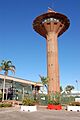
Geoff Monks Port Control Tower (1970-2019)
-
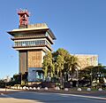
Hedland Tower Integrated Marine Operations Centre (opened 2019)
See also
 In Spanish: Port Hedland para niños
