Portsmouth Earthworks facts for kids
| Location | Portsmouth, Ohio, Southern Ohio and Northeastern Kentucky, |
||||||||||||||||
|---|---|---|---|---|---|---|---|---|---|---|---|---|---|---|---|---|---|
| Region | Southern Ohio and Northeastern Kentucky | ||||||||||||||||
| History | |||||||||||||||||
| Founded | 100 BCE | ||||||||||||||||
| Abandoned | 500 CE | ||||||||||||||||
| Cultures | Adena culture, Hopewell culture | ||||||||||||||||
| Architecture | |||||||||||||||||
| Architectural styles | earthworks | ||||||||||||||||
| Architectural details | Number of monuments: | ||||||||||||||||
|
Horseshoe Mound
|
|||||||||||||||||
| Location | Scioto County, Ohio | ||||||||||||||||
| Nearest city | Portsmouth, Ohio | ||||||||||||||||
| Built | 499-0 BCE, 499-0 CE, 1000-500 CE | ||||||||||||||||
| NRHP reference No. | 74001621 | ||||||||||||||||
| Added to NRHP | 1974 | ||||||||||||||||
|
|||||||||||||||||
The Portsmouth Earthworks are a huge set of ancient mounds and shapes built by the Hopewell culture. These were mound builder people who lived in eastern North America a very long time ago (from about 100 BCE to 500 CE).
This site was one of the biggest places where the Hopewell people held special ceremonies. It is located where the Scioto and Ohio Rivers meet, in what is now Ohio. Most of these ancient structures are now covered by the city of Portsmouth. However, some parts of the complex are protected and listed on the National Register of Historic Places.
Contents
What Are the Portsmouth Earthworks?
Originally, the Portsmouth Earthworks were made of three main parts. They stretched out over twenty miles along the Ohio River valley. These parts even crossed the river into Kentucky in a few spots.
A man named E. G. Squier mapped these earthworks in 1847. His maps were part of an important book about ancient sites in the Mississippi Valley.
Portsmouth Earthworks, Group B
The northern part of the earthworks, called Group B, had many circular shapes. It also featured two large shapes that looked like horseshoes. From these, three sets of parallel walls, like ancient roads, led off in different directions.
- One set of walled roads went across the Ohio River into South Portsmouth, Kentucky. This path led to Portsmouth Earthworks, Group A.
- Another set of walled roads went southeast, also crossing the Ohio River. This path led to Portsmouth Earthworks, Group C.
- The third set of walled roads went northwest. We don't know how far it went, but it might have pointed towards the Tremper Mound and Works, which is about 5 miles away.
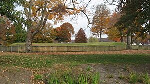
Today, the city of Portsmouth has a public park called Mound Park. This park includes one of the remaining horseshoe-shaped enclosures. It's the only part of the complex that people can easily visit. This horseshoe mound was added to the National Register of Historic Places in 1974.
In recent years, some experts have suggested that the Group B mounds might be part of a giant shape of a woman. This shape, if true, would be about eight miles long. They believe it might represent a Native American story about how humans began. If this idea is correct, it would be the longest shape-mound ever found! However, many parts of this possible shape were destroyed as the city of Portsmouth grew. Other archaeologists are still studying this theory.
Portsmouth Earthworks, Group A
This section is also known as the Old Fort Earthworks. It's located near South Portsmouth, Kentucky, in Greenup County, Kentucky. Group A is a large square shape with two sets of parallel walls. These walls extend from its northeast and southwest corners.
The Old Fort Earthworks area includes several important sites. These include the Old Fort Earthworks itself, Mays Mound, Hicks Mound, and Stephenson Mound. There are also other unnamed mounds and enclosures. This area was also home to Lower Shawneetown, an old settlement where the Fort Ancient and Shawnee people lived and traded with colonists.
Portsmouth Earthworks, Group C
This part is also known as the Biggs Site. Group C was a large series of circles, one inside the other. In the center of these circles was a cone-shaped mound. Experts believe the Adena culture built this section.
This part of the earthworks is in Greenup County, Kentucky. It's a few miles east of South Shore. It was connected to Group B by a raised pathway, like an ancient road.
Gallery of Squier and Davis Maps
 | Aurelia Browder |
 | Nannie Helen Burroughs |
 | Michelle Alexander |


