Potrero Hills (Solano County, California) facts for kids
Quick facts for kids Potrero Hills |
|
|---|---|
| Highest point | |
| Elevation | 107 m (351 ft) |
| Geography | |
| Country | United States |
| State | California |
| Region | Sacramento–San Joaquin River Delta |
| District | Solano County |
| Range coordinates | 38°12′17.693″N 121°58′15.869″W / 38.20491472°N 121.97107472°W |
| Topo map | USGS Denverton |
| Geology | |
| Type of rock | California Coast Ranges |
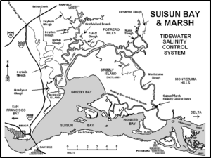
The Potrero Hills are a group of low hills in California. They are located in the southern part of Solano County. These hills are part of the larger Sacramento–San Joaquin River Delta area.
What are the Potrero Hills?
The Potrero Hills are not very tall. Their highest point is about 107 meters (351 feet) above sea level. This makes them more like rolling hills than giant mountains. They are an important natural area in the region.
Where are the Potrero Hills Located?
These hills are found in the southwestern part of the Sacramento Valley. They are northeast of a large body of water called Suisun Bay. The city of Fairfield is located to their southeast.
The Potrero Hills are part of a bigger system. This system is known as the Northern Inner Coast Ranges. These ranges are a section of the larger California Coast Ranges System.
Exploring the Rush Ranch Open Space Preserve
A special place called the Rush Ranch Open Space Preserve is located here. It is part of the San Francisco Bay National Estuarine Research Reserve. This preserve is on the western side of the Potrero Hills, right next to Suisun Bay.
The preserve protects important natural habitats. It is a great place to learn about the local environment. You can often see different kinds of plants and animals there.

 | Delilah Pierce |
 | Gordon Parks |
 | Augusta Savage |
 | Charles Ethan Porter |


