Presque Isle, Wisconsin facts for kids
Quick facts for kids
Town of Presque Isle
|
|
|---|---|

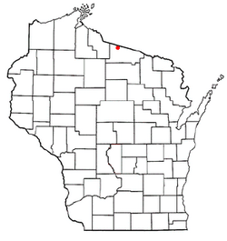
Location of the Town of Presque Isle
|
|
| Country | |
| State | |
| County | Vilas |
| Area | |
| • Total | 74.4 sq mi (192.8 km2) |
| • Land | 61.7 sq mi (159.8 km2) |
| • Water | 12.7 sq mi (33.0 km2) |
| Elevation | 1,680 ft (512 m) |
| Population
(2010)
|
|
| • Total | 616 |
| • Density | 8.3/sq mi (3.2/km2) |
| Time zone | UTC-6 (Central (CST)) |
| • Summer (DST) | UTC-5 (CDT) |
| Area code(s) | 715 & 534 |
| FIPS code | 55-65425 |
| GNIS feature ID | 1583981 |
| Website | http://www.piwi.us/ |
The Town of Presque Isle is a small town in Vilas County, Wisconsin, United States. In 2020, about 808 people lived there. Two small communities, Presque Isle and Katinka Village, are part of the town.
Contents
What Does Presque Isle Mean?
The name "Presque Isle" comes from a French phrase. It means "almost an island." This name is often used for places that are like a peninsula, meaning land surrounded by water on most sides.
Where is Presque Isle Located?
Presque Isle is in the northwest part of Vilas County, Wisconsin. It is in a region known for a lot of snow, called the Lake Superior snowbelt. The area has many beautiful lakes, including Presque Isle Lake. The Presque Isle River also starts here.
The town covers about 74.4 square miles (192.8 square kilometers). Most of this area, about 61.7 square miles (159.8 square kilometers), is land. The rest, about 12.7 square miles (33.0 square kilometers), is water.
Who Lives in Presque Isle?
According to the census from 2000, there were 513 people living in the town. The population density was about 8.3 people per square mile. This means it's a very spread-out area.
Most people living in Presque Isle are adults and seniors. About 31% of the population was 65 years or older in 2000. Only a small number, about 13.8%, were under 18 years old.
How to Get Around Presque Isle
Several main roads, called Vilas County Trunk Highways, help people travel around the town.
- CTH W goes west and south. It connects to USH 51 through other towns like Winchester and Manitowish Waters.
- CTH B runs east and west. It connects to M-64 in Michigan and USH 45 and STH 32 in Land o' Lakes.
- CTH P serves the western part of the town. It also provides access to North Lakeland Elementary School.
- CTH M starts near CTH B and leads to Boulder Junction and then to USH 51.
 |
Bessemer Township | Marenisco Township |  |
|
| Town of Winchester | Town of Land o' Lakes | |||
| Town of Manitowish Waters | Town of Boulder Junction |
See also
 In Spanish: Presque Isle (Wisconsin) para niños
 | George Robert Carruthers |
 | Patricia Bath |
 | Jan Ernst Matzeliger |
 | Alexander Miles |

