Princeton, Florida facts for kids
Quick facts for kids
Princeton, Florida
|
|
|---|---|

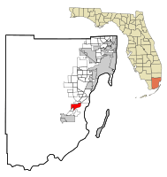
Location in Miami-Dade County and the state of Florida
|
|

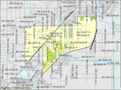
U.S. Census Bureau map showing CDP boundaries
|
|
| Country | |
| State | |
| County | Miami-Dade |
| Area | |
| • Total | 7.47 sq mi (19.34 km2) |
| • Land | 7.42 sq mi (19.21 km2) |
| • Water | 0.05 sq mi (0.13 km2) |
| Elevation | 10 ft (3 m) |
| Population
(2020)
|
|
| • Total | 39,308 |
| • Density | 5,299.72/sq mi (2,046.13/km2) |
| Time zone | UTC-5 (Eastern (EST)) |
| • Summer (DST) | UTC-4 (EDT) |
| ZIP codes |
33032, 33092 (Princeton);
33170 (Goulds) |
| Area code(s) | 305, 786, 645 |
| FIPS code | 12-58975 |
| GNIS feature ID | 0289323 |
Princeton is a special area in Miami-Dade County, Florida, United States. It is called a census-designated place (CDP) because the government counts its population separately. It is also an unincorporated community, meaning it doesn't have its own city government. Princeton is part of the larger Miami metropolitan area in South Florida. In 2020, about 39,308 people lived there. This was a big jump from 22,038 people in 2010.
Contents
History of Princeton
Princeton started as a small town in the early 1900s. It was a stop along the Florida East Coast Railroad. A man named Gaston Drake gave the community its name. He named it after his old school, Princeton University.
Many of the buildings in Princeton were even painted black and orange. These were the colors of Princeton University! Gaston Drake ran a saw mill and a lumber company here. He supplied wood to places like Miami, the Florida Keys, and even Cuba. However, the local trees ran out in 1923.
Where is Princeton Located?
Princeton is located about 24 miles (39 km) southwest of downtown Miami. It is also about 6 miles (10 km) northeast of Homestead.
Princeton shares its borders with other communities. To the north, you'll find Goulds. To the southwest, it borders Naranja. Both of these are also unincorporated areas.
Roads and Transportation
Major roads run through Princeton. U.S. Route 1, also known as Dixie Highway, goes through the community. The Homestead Extension of Florida's Turnpike forms the eastern edge of Princeton. You can get onto the Turnpike from Exit 9, which is Florida State Road 989.
Princeton's Size
The total area of Princeton is about 7.5 square miles (19.3 square kilometers). Most of this area is land. Only a small part, about 0.05 square miles (0.13 square kilometers), is water.
Population and People
Princeton has grown a lot over the years. Here's how its population has changed:
| Historical population | |||
|---|---|---|---|
| Census | Pop. | %± | |
| 1960 | 1,719 | — | |
| 1990 | 7,073 | — | |
| 2000 | 10,090 | 42.7% | |
| 2010 | 22,038 | 118.4% | |
| 2020 | 39,308 | 78.4% | |
| source: | |||
Population in 2020
In 2020, there were 39,308 people living in Princeton. There were 8,356 households and 7,058 families.
The table below shows the different groups of people living in Princeton in 2010 and 2020. It separates people by race and ethnicity.
| Race / Ethnicity (NH = Non-Hispanic) | Pop 2010 | Pop 2020 | % 2010 | % 2020 |
|---|---|---|---|---|
| White (NH) | 1,857 | 2,724 | 8.43% | 6.93% |
| Black or African American (NH) | 6,165 | 7,001 | 27.97% | 17.81% |
| Native American or Alaska Native (NH) | 26 | 22 | 0.12% | 0.06% |
| Asian (NH) | 297 | 574 | 1.35% | 1.46% |
| Pacific Islander or Native Hawaiian (NH) | 10 | 3 | 0.05% | 0.01% |
| Some other race (NH) | 49 | 209 | 0.22% | 0.53% |
| Mixed race or Multiracial (NH) | 218 | 630 | 0.99% | 1.60% |
| Hispanic or Latino (any race) | 13,416 | 28,145 | 60.88% | 71.60% |
| Total | 22,038 | 39,308 | 100.00% | 100.00% |
See also
 In Spanish: Princeton (Florida) para niños
 | Chris Smalls |
 | Fred Hampton |
 | Ralph Abernathy |


