Pyramid Dam facts for kids
Quick facts for kids Pyramid Dam |
|
|---|---|

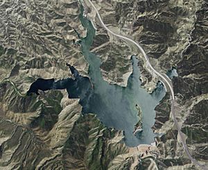
Satellite view of dam and reservoir. Interstate 5 is on the right of the image.
|
|
| Country | United States |
| Location | Los Angeles County, California |
| Coordinates | 34°38′39″N 118°45′50″W / 34.64417°N 118.76389°W |
| Construction began | 1968 |
| Opening date | 1970 |
| Dam and spillways | |
| Type of dam | Embankment |
| Height | 386 ft (118 m) |
| Length | 1,080 ft (330 m) |
| Spillway type | Gated concrete chute |
| Reservoir | |
| Creates | Pyramid Lake |
| Total capacity | 180,000 acre⋅ft (220,000,000 m3) |
| Catchment area | 293 sq mi (760 km2) |
| Surface area | 1,297 acres (525 ha) |
The Pyramid Dam is a large wall built across Piru Creek in northern Los Angeles County, California. It is located north of Castaic and south of Gorman. The dam creates a huge lake called Pyramid Lake. This lake holds water from the West Branch California Aqueduct. The water is then sent to Ventura County and Los Angeles County for people to use. Pyramid Dam and Lake are smaller than the nearby Castaic Dam and Lake, which are about 7 miles (11 km) to the south.
Building the Pyramid Dam
How the Dam Project Started
Building the Pyramid Dam was part of a bigger plan called the California Aqueduct project. This project is also known as the Feather River project. The Feather River is where the water comes from, far away in northern California. In 1960, people in California voted to approve this big water project. The state then used special money, called bonds, to pay for it.
When Was Pyramid Dam Built?
Construction on Pyramid Dam began in 1968. The dam is 386 feet (118 m) tall. It was finished and opened in 1970.
Why Is It Called Pyramid Dam?
The dam gets its name from a mountain right behind it, called Pyramid Cut. Before 1931, this mountain looked like any other. But when workers built a new highway, the Ridge Route, they had to cut away part of the mountain. After the work was done, the mountain looked like a pyramid. This is how it got its unique name.
Facts About Pyramid Lake
How Much Water Does Pyramid Lake Hold?
Pyramid Dam holds back Pyramid Lake. The lake can hold up to 180,000 acre-feet (220,000,000 m3) of water. This covers an area of 1,297 acres (525 ha). The lake is shaped a bit like a Triceratops tooth.
Who Manages the Dam and Lake?
The California Department of Water Resources (DWR) built both the dam and the lake. They still take care of them today. The water stored in Pyramid Lake is very important. It provides water for homes, businesses, and farms in Ventura County and Los Angeles County.
Fun Activities at Pyramid Lake
Since 1974, Pyramid Lake has been a popular spot for fun activities. People can go boating, swimming, and camping there.
The Old Highway and the Lake
How the Lake Changed US 99
During the construction of Pyramid Dam, a major highway called US 99 had to be changed. Starting in 1968, cars were sent to Interstate 5 instead. By 1970, when the dam was finished, water from the Feather River began to fill the area behind the dam. This plan to fill the area was thought of even before the old highway was built.
What Happened to the Old Road?
By 1972, the old US 99 highway was completely underwater, hidden by the lake. Today, the southern part of the old highway that meets the lake is used as a boat ramp. The northern part of US 99 near the lake is now closed to cars.
 | Delilah Pierce |
 | Gordon Parks |
 | Augusta Savage |
 | Charles Ethan Porter |

