
Rakhine State facts for kids
Quick facts for kids
Rakhine State
ရခိုင်ပြည်နယ်
Arakan State
|
||
|---|---|---|
|
State
|
||
| Myanma transcription(s) | ||
| • Burmese | ra.hkuing: prany nai | |
| • Arakanese | Rakhai Pray Nay | |
|
||

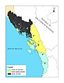
Location of Rakhine State in Myanmar (Burma)
|
||
| Country | ||
| Region | West coastal | |
| Capital | Sittwe | |
| Area | ||
| • Total | 36,778.0 km2 (14,200.1 sq mi) | |
| Area rank | 8th | |
| Highest elevation
(Kema Taung)
|
1,851 m (6,073 ft) | |
| Population
(2014)
|
||
| • Total | 3,188,807 | |
| • Rank | 8th | |
| • Density | 86.70420/km2 (224.5628/sq mi) | |
| Demographics | ||
| • Ethnicities | Arakanese (Rakhine), Rohingya, Kaman, Bamars, Chin, Mro, Khami, That, Maramagyi and others | |
| • Religions |
|
|
| Time zone | UTC+06:30 (MMT) | |
| HDI (2017) | 0.520 low · 13th |
|

Rakhine State (also known as Arakan State) is a state located on the western coast of Myanmar (Burma). It shares borders with Chin State to the north and Bangladesh to the northwest. To the east, it borders other regions of Myanmar. The Bay of Bengal is to its west. The Arakan Mountains separate Rakhine State from central Myanmar. There are also large islands off its coast, like Ramree and Cheduba. Rakhine State covers an area of about 36,762 square kilometers. Its capital city is Sittwe.
Contents
Names of Rakhine State
The area was historically called Arakan in English. In 1990, the government of Myanmar officially changed the English name to Rakhine.
History of Rakhine State
The history of Rakhine State can be divided into several periods. These periods are often named after the main cities where power was centered.
Ancient Kingdoms

The earliest known kingdom in the region was Dhanyawadi. It is said to have existed from ancient times until 327 CE. After Dhanyawadi, the center of power moved to Waithali. The Waithali kingdom ruled from the 4th century to 818 CE. This time is considered a golden age for Rakhine culture and Buddhism. Many old buildings and artifacts from this period have been found.
Later, new kingdoms appeared along the Lemyo River. These were known as the Laymro period. The last major independent kingdom was Mrauk U, founded in 1429. The Rakhine people see this as their most glorious time. Mrauk U was an important trading port in the Bay of Bengal. It traded with places like Arabia and Europe.
Burmese and British Rule
In 1785, the Konbaung dynasty of Burma conquered the Mrauk U kingdom. Rakhine then became part of the Burmese kingdom. In 1824, the First Anglo-Burmese War began. After the war ended in 1826, Rakhine was given to the British East India Company. It became part of British India. Later, it became part of British Burma. The British made Akyab (now Sittwe) the capital.
During World War II, Rakhine was given some freedom under Japanese rule. It even had its own army, the Arakan Defense Force. This force later joined the Allies against the Japanese. Rakhine was the site of many battles during the war.
Independence and Modern Times
In 1948, Burma gained independence. Rakhine became a division within the new country. In 1974, it was officially named "Rakhine State." This recognized the Rakhine people as the main group in the area.
Recent Challenges in Rakhine
Since 2010, Rakhine State has faced some challenges. There have been conflicts between different groups of people living there.
- Conflicts and Displacement: In 2012, there were serious conflicts between Rohingya Muslims and Rakhine Buddhists. These conflicts led to many people having to leave their homes. The government declared a state of emergency to help manage the situation. Many people were displaced and lived in special camps.
- Political Issues: There have been disagreements between the local Rakhine leaders and the national government. In 2018, a protest in Mrauk U led to some people being injured. In 2020, the national election committee decided that voting would not happen in many townships in Rakhine State. This meant about 1.2 million people could not vote.
- Internet Access: From 2019, internet services were limited or shut down in several townships in Rakhine State. This made it hard for people to communicate and get information. Internet services were slowly restored in 2021.
People of Rakhine State
| Historical population | ||
|---|---|---|
| Year | Pop. | ±% |
| 1973 | 1,712,838 | — |
| 1983 | 2,045,559 | +19.4% |
| 2014 | 3,188,807 | +55.9% |
| Source: 2014 Myanmar Census | ||
Rakhine State has a diverse population, meaning many different ethnic groups live there. The Rakhine people are the largest group. There is also a significant population of Rohingya Muslims. Other smaller groups include the Thet, Kamein, Chin, Mro, and Chakma.
Most Rakhine people follow Buddhism. Islam is also a major religion, especially near the border with Bangladesh. Other religions like Christianity and Hinduism are also practiced.
Administrative Divisions
_State_in_Myanmar.png)
Rakhine State is divided into five main districts:
- Sittwe
- Mrauk-U (recently created)
- Maungdaw
- Kyaukpyu
- Thandwe
These districts contain a total of 17 townships and many smaller village areas. Sittwe is the capital city of the state.
Transportation in Rakhine
It can be challenging to travel to Rakhine State from central Myanmar because of the Arakan Mountains. There are only a few highways that cross these mountains. Air travel is a common way to get to Sittwe and the popular beach resort of Ngapali.
The main airports in Rakhine State are:
- Sittwe Airport
- Kyaukpyu Airport
- Thandwe Airport
- Ann Airport
- Manaung Airport

A deep sea port has been built in Kyaukphyu with help from China. This port helps transport natural gas and oil from the Indian Ocean to China. Important rivers for transportation include the Naf River, Kaladan River, and Lemro River.
Economy of Rakhine State
Rakhine is one of the poorer states in Myanmar. A large part of the population lives in poverty.
- Agriculture: Rice is the most important crop, covering about 85% of the farmland. Coconut and nipa palm trees are also grown.
- Fishing: Fishing is a major industry. Most of the fish caught are sent to Yangon, but some are also exported to other countries.
- Natural Resources: Wood products like timber and bamboo come from the mountains. There is also some crude oil production, and potential for more oil and natural gas.
- Tourism: Tourism is slowly growing. The ancient city ruins of Mrauk U and the beautiful Ngapali Beach are popular places for visitors. However, facilities for tourists are still developing.

Rakhine State, especially rural areas, often has electricity shortages. New power plants have been built to help provide more electricity.
Education in Rakhine State
Education opportunities in Myanmar are generally limited outside of the big cities like Yangon and Mandalay. Here's a look at the public school system in Rakhine State for the 2013–2014 school year:
| School Year 2013–2014 | Primary Schools | Middle Schools | High Schools |
|---|---|---|---|
| Schools | 2,515 | 137 | 69 |
| Teachers | 11,045 | 2,909 | 1,337 |
| Students | 370,431 | 100,566 | 26,671 |
Sittwe University is the main university in the state.
Health Care in Rakhine State
Health care in Myanmar is generally not very good. The government spends a small amount of money on health care compared to other countries. Even in public hospitals, patients often have to pay for medicine and treatment. Hospitals outside of major cities often lack basic equipment. Rakhine State has very few hospital beds compared to a city like Yangon.
Here's a summary of the public health care system in Rakhine State in 2002–2003:
| 2002–2003 | Number of Hospitals | Number of Beds |
|---|---|---|
| Specialist hospitals | 0 | 0 |
| General hospitals with specialist services | 1 | 200 |
| General hospitals | 16 | 553 |
| Health clinics | 24 | 384 |
| Total | 41 | 1,137 |
Images for kids
-
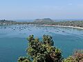
Thandwe, Rakhine State
-
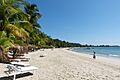
Ngapali Beach, Rakhine state
-
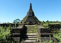
Laung Bwann Brauk Pagoda
-
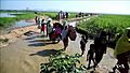
Rohingya refugees entering Bangladesh after being driven out of Rakhine State, 2017
-
Map showing areas where voting was not held in Rakhine State during the 2020 election.


See also
 In Spanish: Estado Rakáin para niños
- List of Arakan Kings
- Arakan Campaign 1942-1943 (for the World War II campaign)
- Rakhine State Cultural Museum
