
Ramsar, Iran facts for kids
Ramsar (Persian: رامسر) is a beautiful city in Iran, located in the Mazandaran region. It's the main city of Ramsar County and is known for its stunning natural beauty, sitting right by the Caspian Sea.
Quick facts for kids
Ramsar
Persian: رامسر
|
|
|---|---|
|
City
|
|
  .jpg)   |
|
| Motto(s):
The Paradise on Earth (Behesht-e rooy-e Zamin)
|
|

Ramsar, Iran
Location in Iran

Ramsar, Iran
Location in Caspian Sea
|
|
| Country | Iran |
| Province | Mazandaran |
| County | Ramsar |
| District | Central |
| Elevation | -21 m (−68.9 ft) |
| Population
(2016)
|
|
| • Total | 35,997 |
| Time zone | UTC+3:30 (IRST) |
Contents
History of Ramsar
In 1971, Ramsar became famous for hosting a very important meeting. This meeting led to the signing of the Ramsar Convention on Wetlands. This international agreement helps protect wetlands around the world. Wetlands are special areas like marshes or swamps that are home to many plants and animals. The treaty was named after Ramsar because it was signed there.
About Ramsar City
Ramsar is located right on the coast of the Caspian Sea. In the past, it was also known as Sakhtsar. The city has a warm and humid climate in summer, and mild winters. Because it's so close to both the sea and green forests, many tourists visit Ramsar all year round. The city also has its own airport.
Ramsar was once a small village. But during the first Pahlavi period, it grew into a beautiful city with many places for tourists to enjoy. Ramsar is the westernmost city in Mazandaran province. It shares borders with the Caspian Sea to the north and other regions like Gilan province to the west.

People and Population
Who Lives in Ramsar?
Most of the people living in Ramsar are Gilaks. They speak a dialect of the Gilaki language. This dialect is similar to the one spoken in the eastern parts of Gilan.
How Many People Live Here?
The number of people living in Ramsar has grown over the years.
- In 2006, about 31,659 people lived in the city.
- By 2011, the population increased to 32,294 people.
- The most recent count in 2016 showed that 35,997 people call Ramsar home.
Geography and Climate
Ramsar's Weather
Ramsar has a humid subtropical climate. This means it has warm, humid summers and cool, wet winters. It's one of the cloudiest cities in Iran. It gets about 1582 hours of sunshine each year.
Northern Iran, including Ramsar, is separated by mountains. This creates a unique environment. For example, the air in Tehran is very dry. But when you travel from Tehran to Ramsar, you go through a tunnel in the mountains. After the tunnel, the air becomes much more humid and the landscape is very green. This is because of the moisture from the Caspian Sea. This misty and rainy weather is a big reason why tourists from drier parts of Iran love to visit.
| Climate data for Ramsar (1955–2010, records 1955-2020) | |||||||||||||
|---|---|---|---|---|---|---|---|---|---|---|---|---|---|
| Month | Jan | Feb | Mar | Apr | May | Jun | Jul | Aug | Sep | Oct | Nov | Dec | Year |
| Record high °C (°F) | 31.0 (87.8) |
28.4 (83.1) |
36.8 (98.2) |
37.0 (98.6) |
34.4 (93.9) |
38.0 (100.4) |
35.6 (96.1) |
35.6 (96.1) |
35.2 (95.4) |
37.0 (98.6) |
32.0 (89.6) |
29.0 (84.2) |
38.0 (100.4) |
| Mean daily maximum °C (°F) | 10.9 (51.6) |
10.6 (51.1) |
11.9 (53.4) |
16.4 (61.5) |
21.4 (70.5) |
25.9 (78.6) |
28.6 (83.5) |
28.8 (83.8) |
25.8 (78.4) |
21.8 (71.2) |
17.3 (63.1) |
13.5 (56.3) |
19.4 (66.9) |
| Daily mean °C (°F) | 7.4 (45.3) |
7.3 (45.1) |
9.1 (48.4) |
13.3 (55.9) |
18.2 (64.8) |
22.6 (72.7) |
25.2 (77.4) |
25.4 (77.7) |
22.7 (72.9) |
18.4 (65.1) |
13.7 (56.7) |
9.8 (49.6) |
16.1 (61.0) |
| Mean daily minimum °C (°F) | 4.0 (39.2) |
4.1 (39.4) |
6.3 (43.3) |
10.1 (50.2) |
14.9 (58.8) |
19.2 (66.6) |
21.7 (71.1) |
22.0 (71.6) |
19.5 (67.1) |
15.1 (59.2) |
10.1 (50.2) |
6.1 (43.0) |
12.8 (55.0) |
| Record low °C (°F) | −10.0 (14.0) |
−6.0 (21.2) |
−3.0 (26.6) |
0.0 (32.0) |
5.0 (41.0) |
9.0 (48.2) |
10.8 (51.4) |
16.0 (60.8) |
10.0 (50.0) |
5.0 (41.0) |
−1.2 (29.8) |
−2.0 (28.4) |
−10.0 (14.0) |
| Average precipitation mm (inches) | 78.4 (3.09) |
73.5 (2.89) |
85.2 (3.35) |
53.3 (2.10) |
46.1 (1.81) |
57.9 (2.28) |
38.0 (1.50) |
65.4 (2.57) |
161.5 (6.36) |
260.2 (10.24) |
177.4 (6.98) |
109.3 (4.30) |
1,206.2 (47.47) |
| Average precipitation days (≥ 1.0 mm) | 9.0 | 8.7 | 11.0 | 8.3 | 7.3 | 4.9 | 3.9 | 6.6 | 8.6 | 11.6 | 9.2 | 8.8 | 97.9 |
| Average snowy days | 0.8 | 1.1 | 0.5 | 0.0 | 0.0 | 0.0 | 0.0 | 0.0 | 0.0 | 0.0 | 0.0 | 0.2 | 2.6 |
| Average relative humidity (%) | 84 | 85 | 87 | 86 | 84 | 81 | 79 | 81 | 84 | 85 | 84 | 84 | 84 |
| Average dew point °C (°F) | 4.9 (40.8) |
4.8 (40.6) |
7.1 (44.8) |
10.8 (51.4) |
15.8 (60.4) |
19.3 (66.7) |
21.4 (70.5) |
21.8 (71.2) |
19.7 (67.5) |
15.8 (60.4) |
10.5 (50.9) |
6.8 (44.2) |
13.2 (55.8) |
| Mean monthly sunshine hours | 105.6 | 97.1 | 92.7 | 119.7 | 165.5 | 189.6 | 188.9 | 168.7 | 126.1 | 119.1 | 111.1 | 98.2 | 1,582.3 |
| Source 1: IRIMO (records) | |||||||||||||
| Source 2: NOAA(dew point 1991-2020) | |||||||||||||
Natural Radioactivity
Ramsar is known for having some areas with naturally high levels of radioactivity. This comes from hot springs nearby and building materials made from the rocks around them. Some residents in these areas experience higher levels of natural background radiation.
Scientists are studying these areas to understand the effects on people. Early studies suggested there might not be harmful effects, or even some positive ones. However, more research is needed to be sure. The radioactivity is due to the local rocks. Underground water dissolves natural elements like radium and brings them to the surface through hot springs. These springs are popular spas for locals and tourists.
The radium can settle into a type of rock called travertine, which has been used to build homes. It can also mix with the soil and drinking water. This natural radioactivity is different from man-made radiation.
Protecting Wetlands: The Ramsar Convention
The Convention on Wetlands was signed in Ramsar in 1971. It's an important agreement between countries to protect wetlands and their natural resources. Wetlands are vital for many plants and animals.
Today, many countries are part of this convention. They work together to save wetland sites around the world. These countries meet every three years to discuss how to best protect these important natural areas.
Tourism in Ramsar

Ramsar is a very popular place for Iranian tourists to visit. It's a great seaside resort. The city offers many attractions:
- Hot springs: Natural springs with warm water, good for relaxing.
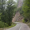
- Green forests: Beautiful forests of the Alborz Mountains are perfect for hiking.
- Ramsar Palace: The former vacation home of the last Shah of Iran.
- Hotel Ramsar: A famous old hotel.
About 27 kilometers (17 miles) south of Ramsar, high up in the Alborz mountains, is Javaher Deh village. This village is a major tourist spot in Ramsar County. The road to Javaher Deh from Ramsar goes through the scenic Safarood forest park.
Sister Cities
Ramsar has special connections with other cities around the world, called "twin towns" or "sister cities." These connections help promote friendship and understanding between different cultures. Ramsar is twinned with:
Famous People from Ramsar
Many notable people have come from Ramsar, including:
- Mohammad Reza Khalatbari (born 1983) - A well-known football player.
- Esfandiar Rahim Mashaei (born 1960) - A politician.
- Hossein Khalatbari (1949-1985) - An Iranian fighter pilot.
- Elika Abdolrazzaghi (born 1979) - An actress in cinema, theater, and TV.
- Mohammad-Ali Taskhiri (1948-2020) - An Iranian cleric and diplomat.
- Rahim Ebadi (born 1957) - A politician.
Images for kids
-
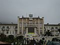
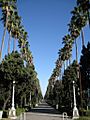
The Old Hotel of Ramsar
-
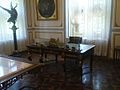
The desk of Mohammad Reza Shah
-
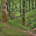
Dalikhani Forest
-
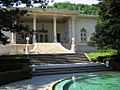
Marble palace in Ramsar
-
Ramsar Hotel
-
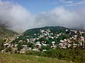
Javaher Deh village
-
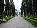
A walkway in front of the old hotel
-
Dalikhani Forest
-
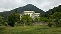
A palace in Ramsar
-
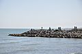
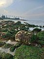
Ramsar Caspian coast
-
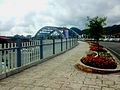
Ramsar Bridge
-
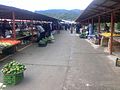
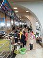
Ramsar Bazaar
-
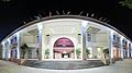
Ramsar International Shopping
-
Ramsar Fish Market
-
Ramsar seaside


.jpg)


See also
 In Spanish: Ramsar (Irán) para niños
