
Rapa Nui National Park facts for kids
Quick facts for kids Rapa Nui National Park |
|
|---|---|
|
IUCN Category II (National Park)
|
|

Ahu Akivi moai that face the ocean
|
|
| Location | Easter Island, Chile |
| Nearest city | Hanga Roa |
| Area | 6,800 hectares (17,000 acres) |
| Established | 1935 |
| Visitors | 52,202 (in 2012) |
| Governing body | Ma'u Henua Indigenous Community |
| Type: | Cultural |
| Criteria: | i, iii, v |
| Designated: | 1995 (19th session) |
| Reference #: | 715 |
| Region: | Latin America and the Caribbean |
Rapa Nui National Park (which is called Spanish: Parque nacional Rapa Nui in Spanish) is a special protected area. It is located on Easter Island in Chile. This park is also a UNESCO World Heritage Site.
Rapa Nui is the traditional Polynesian name for Easter Island. The island sits far out in the southeastern Pacific Ocean. It is at the very edge of the Polynesian Triangle. Chile took control of the island in 1888.
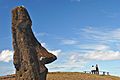
The park is famous for its 887 huge stone statues. These statues are known as "moai". The early Rapa Nui people created them. They lived on the island starting between 300 and 1200 AD.
Most of Easter Island is part of Rapa Nui National Park. UNESCO named it a World Heritage Site on March 22, 1996. This was because of its important cultural value.
Today, the Ma'u Henua Polynesian Indigenous Community manages the park. This is the first local group to have control over their ancestral lands. The Rapa Nui people now protect and preserve their heritage. On December 1, 2017, former President Michelle Bachelet returned these lands to the indigenous people. Now, money from the park helps the island and its natural treasures.
Contents
Geography of Rapa Nui

Easter Island is very far from other places. It marks the eastern edge of Polynesia. It is about 3,700 kilometres (2,300 mi) west of Chile. The nearest inhabited place is Pitcairn Island, about 2,200 km (1,400 mi) away. This makes Easter Island the most isolated place where people live on Earth.
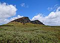
The park is shaped like a triangle. It is about 23 km (14 mi) long and 11 km (6.8 mi) wide. It is home to an ancient culture that built huge stone statues. These "moai" were carved from volcanic rocks. The island has volcanoes and a rough coastline. Its height above sea level goes up to 300 m (980 ft). There are also freshwater lakes and volcanic craters. The coastline is slowly worn away by the ocean.
Climate of the Park
The park has a warm, sub-tropical climate. From October to April, southeast trade winds blow. The island gets about 1,250 millimetres (49 in) of rain each year. Most of the rain falls during the winter. The average temperature is about 19 °C (66 °F) in winter. In summer, it rises to about 24 °C (75 °F).
History of Easter Island


The Rapa Nui people first settled on the island between 300 and 1200 CE. The Chilean Government created the park in 1935. At first, the native people lived in a small area near the capital city, Hanga Roa. The rest of the land was rented out for sheep farming.
A movement for independence began in 1964. Because of this, the sheep farming leases ended in the 1980s. The entire island was then declared a historic park. The island's population grew from 2,770 in 1972 to 3,792 by 2002. Most people live in the capital.
Chile took control of the island in 1888. The island is famous for its 887 "moai" stone statues. Most of the island is now part of Rapa Nui National Park. UNESCO recognized it as a World Heritage Site on March 22, 1996.
In October 2022, a forest fire spread through the park. It caused serious damage to wetlands and some moai statues.
Culture and Moai Statues

The moai statues in the park vary in height. They can be from 2 to 20 meters (6 to 65 feet) tall. The stone used for carving them is a special yellow-brown volcanic rock. This rock is only found at Rano Raraku, on the island's southeast side. Some moai were also carved from red volcanic rock.
The ceremonial platforms where moai stand are called "ahu". These impressive structures are usually built near the coast. Many unfinished moai can still be seen in the quarries. Creating and moving 887 statues was a huge effort.
Moai statues have been restored since 1950. Between 1837 and 1864, all the standing statues were toppled. This likely happened during conflicts, but the exact reasons are unknown. Later, with international help, they were put back up. The moai represented important ancestors. People believed these ancestors gave "mana" (spiritual power) to their leaders. The park also has ancient rock carvings and paintings.

A different religious practice, the Birdman cult, replaced the moai worship. This cult was centered at Orongo. This ceremonial site is called Mata Ngarau. It is located at 250 metres (820 ft) high. It sits on a narrow ridge between the ocean and the deep crater of Rano Kau volcano. This volcano last erupted about 150,000 to 210,000 years ago.
The first people on the island called it "Te Pito o Te Henua". This means "the navel/end of the world." The first European to find the island was Dutch explorer Jacob Roggeveen. He discovered it on Easter Day in 1722. So, he named it "Easter Island." He saw that the people had different skin colors and hair.
In the 19th century, a visitor from Tahiti named the island "Rapa Nui". He thought it looked like Rapa but was bigger (nui means big). In Chile, the island is called "Isla De Pascua", which is Spanish for Easter Island.
Ecology of Rapa Nui
Easter Island is very isolated. This means it has many unique animals and plants found nowhere else. The park is managed as an IUCN Category II protected area. The island's environment has changed a lot over time. Long ago, it had palm trees and a thick forest. Before Polynesians settled there in the 4th century, the island was covered in trees, shrubs, ferns, and grasses. Now, the island is mostly covered in grass. Only a few ornamental trees and shrubs are scattered around.
Flora: Plants of the Park
Out of 150 recorded plant species, 45 are found only on Easter Island. However, grass covers most of the island. There are three types of grass unique to the island. In ancient times, the only native trees were Sophora toromiro and Paschalococos. The toromiro tree is now extinct on the island. Paschalococos might be related to the Chilean palm, Jubaea chilensis.
In the grassy areas, you mostly find Austrostipa and Nassella species. Other plants found there were brought to the island by people. Among the shrubs, the hau hau (Triumfetta semitriloba) is still present. However, Coprosma spp. is no longer seen. The wood of the extinct Jubaea palm was used to move the huge moai statues. Carbon dating shows this tree existed on the island until the 17th century.
Ferns are native to Rapa Nui. Four of the 15 fern species are unique to the island. These are Doodia paschalis, Polystichum fuentesii, Elaphoglossum skottsbergii, and Thelypteris espinosae. Triumfetta semitriloba, once thought extinct, was found again in 1988. A 1991 report listed 46 native plant species, including nine unique ones. It also noted 166 introduced species. Tall bulrushes like totora are found in the lower Rano Raraku crater. Sailors from South America probably brought them.
Fauna: Animals of the Park
The only native mammals on the island are rodents and carnivorans. The reptiles found here include three types of marine turtles. There are also two kinds of land lizards: Lepidodactylus lugubris and Ablepharus boutoui poecilopleurus.
Four bird species live on the island. Three are land birds and one is a sea bird. These include Fregata nubor, the red-tailed tropicbird (Phaethon rubricauda), and the Kermadec petrel. Three tiny moth species are reported in the park. One of these is Asymphorodes trichogramma. These moths are not linked to South American species.
Conservation Efforts
New plants have been brought in for livestock to eat. Forest fires are also common. Both threaten the island's native plants. Studies show that the land is damaged by erosion and many tourists.
The park was created in 1935. But the first plan to manage it was not put in place until the 1980s. At first, there wasn't enough money for conservation. So, international groups helped with money and advice. Chile then set up a Rapa Nui Monuments Board. This group could make decisions without waiting for the government.
The World Monument Fund started working here in 1968. UNESCO later recognized the site as a World Heritage site. An airport was built in 1965 and expanded in 1985. This made it easier for planes to fly between Chile and the island. More scientists became interested in the island's heritage. They now study its ancient culture.
The Ma'u Henua Polynesian Indigenous Community now manages Rapa Nui National Park. This is the first independent group on the island. The Rapa Nui people have taken back control of their ancestral lands. They are in charge of managing, preserving, and protecting their heritage. On December 1, 2017, former President Michelle Bachelet returned the park to the indigenous people. For the first time, money from the park is used to help the island and protect its natural heritage.
The park's value comes from its important cultural heritage. The park's management plan focuses on studying these ancient sites. The park is divided into different zones for various uses. These include areas for ancient sites, natural areas, and areas for visitors. The plan combines protecting the ancient sites with farming, raising animals, and traditional fishing.
Sister Parks
Images for kids
-
Monument in Rapa Nui
-
Rapa Nui, Easter Island
-
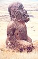
Tukuturi, a moai at Rano Raraku
-
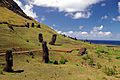
Outer slope of the Rano Raraku volcano, the quarry of the moai with many uncompleted statues.
-
Rano Raraku volcano from the south


See also
 In Spanish: Parque nacional Rapa Nui para niños
