Raton-Clayton volcanic field facts for kids
Quick facts for kids Raton-Clayton volcanic field |
|
|---|---|

|
|
| Highest point | |
| Elevation | 1,550 to 2,700 meters (5,090 to 8,860 ft) |
| Dimensions | |
| Area | 20,000 square kilometres (7,700 sq mi) |
| Geography | |
| Location | New Mexico, US |
| Topo map | USGS Folsom |
| Geology | |
| Age of rock | Pliocene to Holocene? |
| Mountain type | Volcanic field |
| Volcanic arc/belt | Rio Grande Rift |
| Last eruption | 58,000 to 62,000 years ago |
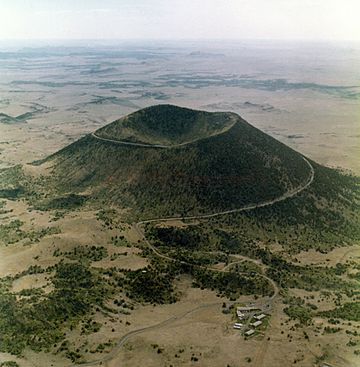
The Raton-Clayton volcanic field is a special area in New Mexico, United States. It has many volcanoes. One famous spot here is the Capulin Volcano National Monument. This volcanic field is the easternmost one in North America that formed in the last 66 million years.
How the Volcanoes Formed
The Raton-Clayton volcanic field sits on something called the Jemez Lineament. Think of this as a weak spot in the Earth's outer layer, or crust. It might be where two very old pieces of the Earth's crust meet.
This area also sits above the Alvarado Ridge. This is a huge uplift that stretches across the land. Deep inside the Earth, hot, melted rock called magma is rising. As it rises, it melts even more.
The magma finds its way up through the weak spots in the Earth's crust. This has created about 125 different types of volcanoes. These include cinder cones, domes, and even one large shield volcano called Sierra Grande.
Volcanoes started forming here about 7.2 million years ago. The most recent eruption happened about 60,000 years ago. This was at Capulin Peak. Over time, the rising magma mixed with melted rock from the Earth's lower crust. This created different kinds of volcanic rock. These rocks include basalt, andesite, and dacite.
Stages of Volcanic Activity
Scientists have divided the volcanic activity here into three main stages:
- Raton Stage: This stage happened from 9.1 to 3.6 million years ago. It mostly produced a type of rock called olivine basalt. This rock forms the tops of many flat-topped hills, or mesas, in the area. Some dacite rock was also formed near the end of this stage.
- Clayton Stage: This stage followed the Raton stage, from 3.6 to 2.0 million years ago. It started in the eastern part of the field. The lava from this stage was more alkaline. This means it had different minerals in it.
- Capulin Stage: This final stage began less than two million years ago. The lava from this stage was very similar in its makeup. This suggests that all the eruptions during this time came from the same underground magma chamber.
Sierra Grande is the biggest volcano in this field. It was active during both the Raton and Clayton stages. Its rocks are between 3.8 and 2.6 million years old. Sierra Grande is made of a rock type called two-pyroxene andesite. This rock is not found in many other places in the Raton-Clayton volcanic field.
Important Volcanoes
Here are some of the notable volcanoes in the Raton-Clayton volcanic field:
| Name | Elevation | Location | Last eruption | |
| meters | feet | Coordinates | ||
| Baby Capulin | 2,094 | 6,870 | 36°48′55″N 103°56′10″W / 36.81528°N 103.93611°W | 44,800 to 42,600 years ago |
| Capulin | 2,494 | 8,182 | 36°46′57″N 103°58′11″W / 36.78250°N 103.96972°W | 54,200 to 52,400 years ago |
| Robinson Mountain | 2,452 | 8,045 | - | |
| Sierra Grande | 2,658 | 8,720 | 36°42′20″N 103°52′34″W / 36.70556°N 103.87611°W | about 2 million years ago |
 | Sharif Bey |
 | Hale Woodruff |
 | Richmond Barthé |
 | Purvis Young |

