Red Mountains (Utah) facts for kids
Quick facts for kids Red Mountains (Utah) |
|
|---|---|

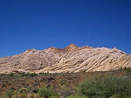
view of Red Mountains
|
|
| Highest point | |
| Peak | unnamed? |
| Elevation | 4,915 ft (1,498 m) |
| Dimensions | |
| Length | 7 mi (11 km) (circular) |
| Width | 7 mi (11 km) |
| Geography | |
| Country | United States |
| Communities | Veyo, Gunlock, Shivwits, Ivins, Santa Clara and Saint George |
| Range coordinates | 37°13′15″N 113°41′16″W / 37.22083°N 113.68778°W |
| Topo map | USGS Veyo and St George NW |
The Red Mountains in Washington County, Utah, are a mostly round-shaped group of mountains. They are about 7 miles (11 kilometers) long. These mountains are surrounded by bigger mountain ranges like the Bull Valley and Pine Valley Mountains to the northwest and northeast. To the southwest, you'll find the smaller Beaver Dam Mountains.
Rivers and streams flow between these mountains. The Santa Clara River winds around the western and northwestern parts of the Red Mountains. This river starts from the side of the Bull Valley Mountains, which are to the north and northwest of the Red Mountains.
A special part of the Red Mountains is Snow Canyon State Park, which covers the southeastern area and extends even further south. This park is also about 7 miles long.
About the Red Mountains
The Red Mountains are almost perfectly round, except for their southeastern side where Snow Canyon and West Canyon meet.
The tallest point in the range doesn't have a name, but it's about 4,915 feet (1,498 meters) high.
Getting to the Mountains
The Red Mountains are easy to reach because many towns and roads are located around them.
The Santa Clara River runs along the west and northwest sides of the mountains. Gunlock Road follows this river and the base of the mountains. You can take this road from Veyo in the north, through Gunlock on the northwest side, and down to the west of Shivwits.
From Shivwits, which is at the southern base of the mountains, you can take Highway 91 (which used to be U.S. 91). This road starts near Ivins (also at the southern base) and connects to Utah Route 18 in St. George, Utah. St. George is about 5 miles from Ivins.
Utah Route 18 runs along the entire eastern side of the Red Mountains. On the southeastern side, a road leads into Snow Canyon State Park. To the east and northeast, Utah 18 goes through Diamond Valley. From here, you can find unpaved roads that lead to the northeast and north parts of the Red Mountains, and also to the southwest side of the Pine Valley Mountains.


