
Pine Valley Mountains facts for kids
Quick facts for kids Pine Valley Mountains |
|
|---|---|

Pine Valley Mountains and St. George
|
|
| Highest point | |
| Peak | Signal Peak |
| Elevation | 10,365 ft (3,159 m) |
| Dimensions | |
| Length | 35 mi (56 km) N/S |
| Width | 28 mi (45 km) E/W |
| Area | 591 sq mi (1,530 km2) |
| Geography | |

Pine Valley Mountains
Location in Utah
|
|
| Country | United States |
| State | Utah |
The Pine Valley Mountains are a mountain range in the U.S. state of Utah. They are found in Washington County, just north of the city of St. George. The highest point in these mountains is Signal Peak, which stands at 10,365 feet (3,159 meters) tall. These mountains are part of the Dixie National Forest. To the south, they are next to the Red Cliffs National Conservation Area.
Contents
How the Mountains Formed: Geology Facts
The Pine Valley Mountains were created by something called the Pine Valley Laccolith. A laccolith is a large, dome-shaped mass of magma that pushes up the rock layers above it without breaking through to the surface. This one is the biggest laccolith in the United States, and maybe even the world!
Volcanic Activity and Lava Flows
This huge laccolith formed over 20 million years of volcanic activity. Imagine hot, molten rock (magma) trying to reach the surface. After a lot of volcanic material piled up, the magma couldn't break through anymore. Instead, it pushed sideways, creating a thick layer of rock underground. This formed the Pine Valley laccolith.
Even after the laccolith was exposed by erosion, volcanoes kept erupting. The newest lava flows are about 1 to 1.6 million years old. You can still see many volcanic cinder cones in the lower parts of the mountains. These cones are about 20,000 years old.
How Valleys and Lakes Were Created
These lava flows also shaped the land. The valley where the town of Pine Valley is located was formed when lava blocked the Santa Clara River. This created a lake! Over time, sediment (like dirt and sand) filled the lake until it reached the height of the lava dam. This sediment now forms the flat ground of Pine Valley and other nearby areas.
Water Flow and Watersheds
The Pine Valley Mountains sit on a special line that divides water flow. Water on one side flows into the Great Basin, which is an area where water doesn't reach the ocean. Water on the other side flows into the Virgin River, which eventually joins the Colorado River. There's even a tunnel called the Chinamen's Canal that moves water from the Colorado River system into the Great Basin system! From these mountains, you can also see Zion National Park to the east.
Exploring the Wilderness Areas
A big part of the Pine Valley Mountains is protected as the Pine Valley Mountain Wilderness. This area covers 50,232 acres (20,328 hectares), making it the fourth largest wilderness area in Utah. There's also a smaller protected area called the Cottonwood Forest Wilderness, which is 2,643 acres (1,069 hectares) and sits at the southeastern end of the mountains. These wilderness areas help protect the natural environment.
Amazing Plants and Animals: Flora and Fauna
The Pine Valley Mountains are home to many different kinds of plants and animals. You'll find spruce-fir forests here, including a large area of untouched Engelmann spruce trees. There are also many open meadows, some as large as 50 acres (20 hectares).
Rare and Special Species
Several special species live in these mountains. Some are threatened, endangered, or sensitive, meaning they need protection. These include the Bonneville cutthroat trout, Townsend's big-eared bat, and the pygmy rabbit.
Plant Diversity: A Botanical Wonderland
Botanists (plant scientists) say that Pine Valley Mountain has the most diverse plant life of any mountain range in Utah. A study done between 1985 and 1987 found almost 1,000 different plant species!
Some interesting plants found here include:
- Bitter cherry (Prunus emarginata)
- Common sandweed (Athysanus pusillus)
- Lemmon's onion (Allium lemmonii)
Scientists also found 19 types of ferns, 18 gymnosperms (like conifers), and 150 types of monocots (including 86 kinds of grasses and 10 types of orchids). The most common plant families are Asteraceae (like sunflowers), Poaceae (grasses), and Fabaceae (peas and beans).
Unique Plant Discoveries
Here are some cool plant finds in the Pine Valley Mountains:
- Forked spleenwort (Asplenium septentrionale): A small, grass-like fern found in one high-up spot.
- Grape fern (Botrychium): Found in the high meadows.
- Young bristlecone pines (Pinus longaeva): These very old trees grow along the mountain crest.
- Sequoia tree (Sequoiadendron giganteum): A single, very large tree planted near the Browse guard station.
- Wild pistachios (Pistacia atlantica): These trees have grown wild from old orchards and are now found in the southern foothills. Birds helped spread their seeds!
- Dollarjoint cactus (Opuntia chlorotica): Found scattered in the southern foothills.
- Pine Valley goldenbush (Ericameria crispus): This plant with unique crinkled leaves is only found in the Pine Valley Mountains.
- Utah spikemoss (Selaginella utahensis): A rare plant found in shady spots on Navajo sandstone.
Almost all of Utah's conifer trees grow in the Pine Valley Mountains. Only the lodgepole pine (Pinus contorta) is missing!
Fun Things to Do: Recreation
The Pine Valley Mountains offer many ways to have fun outdoors! You can go hiking on trails, try rock climbing, or enjoy camping under the stars. It's also a great place for wildlife watching, fishing, and hunting. You can even go horseback riding or enjoy boating on a reservoir.
Tallest Spots: Peaks
The Pine Valley Mountains have many peaks. Here are some of the most notable ones:
| Mountain Peak | Elevation (feet) | Location |
|---|---|---|
| Signal Peak | 10,365 | 37°19′10″N 113°29′32″W / 37.319537°N 113.492205°W |
| Burger Peak | 10,322 | 37°19′32″N 113°30′04″W / 37.325469°N 113.501154°W |
| Big Point | 10,023 | 37°24′51″N 113°22′51″W / 37.4141°N 113.3809°W |
| Gardner Peak | 9,488 | 37°23′29″N 113°27′06″W / 37.391335°N 113.451708°W |
| Timber Mountain | 9,022 | 37°28′15″N 113°23′46″W / 37.4708°N 113.3961°W |
| Mount Baldy | 8,894 | 37°25′53″N 113°20′11″W / 37.4314°N 113.3364°W |
| Rencher Peak | 8,789 | 37°30′06″N 113°24′41″W / 37.5016°N 113.4114°W |
Images for kids
-
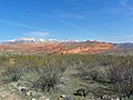
Pine Valley Mountains with the Red Cliffs
-

Pine Valley Mountain from Lower Sand Cove at dusk
-
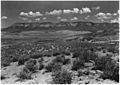
Pine Valley Mountains from the Hurricane Fault
-
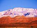
Sunrise on Pine Valley Mountain and Red Cliffs National Conservation Area
-
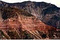
The Pine Valley Laccolith resting on the Claron Formation


_showing_Pine_Valley_Mountain_in_distance_with_Vermillion_Cliff..._-_NARA_-_520420.jpg)


