
Red River (Cumberland River tributary) facts for kids
Quick facts for kids Red River |
|
|---|---|

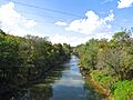
The Red River in Adams, Tennessee
|
|
| Country | United States |
| States | Tennessee and Kentucky |
| Physical characteristics | |
| Main source | Sumner County, Tennessee 358 ft (109 m) |
| River mouth | Cumberland River |
| Length | 100 mi (160 km) |
| Basin features | |
| Basin size | 1,482 sq mi (3,840 km2) |
The Red River is a river about 100 miles (160 km) long. It flows through parts of north-central Tennessee and south-central Kentucky. It is a major branch, or "tributary," of the Cumberland River.
The river gets its name from its water color. It often looks reddish because of the clay and silt it carries. This silt contains iron, which gives it a red tint. As farming methods change, the river's color might become less intense over time.
Contents
Where Does the Red River Start?
The Red River begins in Sumner County, Tennessee. This is south of a town called Portland. From there, it flows mostly towards the northwest.
Along its path, several roads cross over it. A big branch of the river, called the South Fork, starts nearby. It flows next to the main river for several miles.
The River's Journey Through States
The Red River briefly enters Simpson County, Kentucky. Then it flows into Logan County, Kentucky. The South Fork also enters Logan County and joins the main Red River west of Adairville.
The river then crosses back into Robertson County, Tennessee. It continues to flow mostly west, making some gentle curves. Near Adams, Tennessee, another important branch called Sulphur Fork joins it. This meeting point is at a historic place called Port Royal.
In the past, tobacco was loaded onto boats here. A covered bridge also used to cross the river at this spot. Both the Red River and Sulphur Fork form part of the border between Robertson County and Montgomery County.
Reaching the Cumberland River
As the Red River flows towards Clarksville, it is crossed by Interstate 24. It used to mark the border of Clarksville and a community called New Providence. New Providence is now part of Clarksville.
About 1.5 miles (2.4 km) before it reaches the Cumberland River, the West Fork of the Red River joins it. This is its last branch. The Red River is crossed by U.S. Route 41 Alternate just before it flows into the Cumberland River.
What is the Red River Watershed?
The area of land that collects all the rain and snowmelt that flows into the Red River is called the Red River Watershed. This entire area is very large, covering about 1,482 square miles (3,838 square kilometers).
Fun Places Along the Red River
There are some interesting spots to visit near the Red River.
- Red River Meeting House: This historic building is in Logan County, Kentucky. It was an important place for a religious movement called the Second Great Awakening in the early 1800s.
- Red River Canoe: Located in Adams, Tennessee, this place lets you rent canoes and kayaks. The river here has a gentle, slow current, which is great for paddling.
- Bell Witch Cave: This famous cave is found on the left side of the river. It is known for local legends and stories.
Images for kids
-
The Red River in Adams, Tennessee
