Redcliffe Caves facts for kids
 |
|
| Location | |
|---|---|
| Location | Redcliffe |
| City | Bristol |
| Country | England |
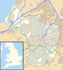
| Coordinates | 51°26′53″N 2°35′35″W / 51.448°N 2.593°W |
| Production | |
| Products | Sand for glass and pottery manufacture |
| History | |
| Opened | Middle Ages |
| Closed | Mid 19th century |
| Owner | |
| Company | Bristol City Council |
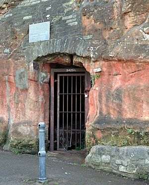
The Redcliffe Caves are a fascinating network of tunnels located beneath the Redcliffe area of Bristol, England. These aren't natural caves; they were dug by people over many centuries.
People started digging into the soft, red sandstone cliffs during the Middle Ages. They needed the sand for making things like glass and pottery. More digging happened from the 1600s to the early 1800s. The caves were then used to store goods brought in by ships.
There's a local story that enslaved people were kept in the caves during the Bristol slave trade, but this is not true. However, there is some evidence that prisoners from the French Revolutionary Wars or Napoleonic Wars might have been held there.
After the last glass factory closed, the caves were used for storage. Later, they became a place where waste was put. Today, the caves are not usually open to the public. But sometimes, they are used for special events like film screenings or music performances.
The parts of the caves that have been explored cover more than one acre. However, some areas are now blocked off, so no one knows exactly how big the entire cave system is.
Contents
Exploring Redcliffe Caves
The Redcliffe Caves were created by people digging into the red sandstone cliffs. These cliffs gave the Redcliffe area its name. The caves are located near Bristol Harbour, behind Phoenix Wharf and Redcliffe Wharf.
The first digging began in the Middle Ages. However, most of the tunnels were dug between the mid-1600s and the early 1800s. In the larger cave rooms, the natural stone columns were not strong enough to hold up the roof. So, people added extra supports made of stone, brick, and even concrete.
Who Lived in the Caves?
In 1346, a religious person called John Sparkes lived in the caves as a hermit. He prayed for a rich supporter named Lord Thomas of Berkeley. Other hermits also lived in the caves between the 1300s and 1600s.
What Were the Caves Used For?
The main reason the caves were dug was to get sand for making glass and pottery. Bristol was a big center for these industries.
While the story about enslaved people being held in the caves is a myth, the caves were used to store goods. These goods arrived on ships from places like Africa and the Caribbean. There is some proof that prisoners from the French Revolutionary Wars or Napoleonic Wars were kept in the caves. They might have been working on building the New Cut, a waterway in Bristol.
After the last glass factory in Bristol shut down, the caves were used for storage. They also became a place where waste was dumped. Some of this waste came from the Redcliffe Shot Tower. This tower made lead shot, and waste from that process was put into the caves from 1782 until 1968.
During World War II, some parts of the caves were checked to see if they could be used as air raid shelters. A bomb created a hole into the caves, which was later filled in. This blocked access to some parts of the cave system.
Today, the caves are sometimes used for fun events. They have hosted the Bristol Film Festival and even theatre shows.
How Big Are the Caves?
The full size of the Redcliffe Caves is still a bit of a mystery. Part of the cave system was split by a railway tunnel. People believe the caves extend even further than what can be seen today, going south of the railway line.
The explored and mapped parts of the caves cover more than one acre. They stretch almost as far as the old Bristol General Hospital. It's also thought that the caves might have once connected to the crypt of St Mary Redcliffe church. In the 1950s, a survey explored and mapped the accessible areas. This survey gave clues about how much larger the caves might be.
Several buildings in the area used to have, or still have, ways to get into the caves from their basements. For example, the Ostrich pub has a part of its wall removed to show a section of one of the caves.
- Prince's Wharf, including M Shed, Pyronaut and Mayflower adjoining Prince Street Bridge
- Dry docks: SS Great Britain, the Matthew
- St Augustine's Reach, Pero's Bridge
- Bathurst Basin
- Queen Square
- Bristol Temple Meads railway station
- Castle Park
- Redcliffe Quay and Redcliffe Caves
- Baltic Wharf marina
- Cumberland Basin & Brunel Locks
- The New Cut
- Netham Lock, entrance to the Feeder Canal
- Totterdown Basin
- Temple Quay
- The Centre
- Canons Marsh, including Millennium Square and At-Bristol
- Underfall Yard
- Bristol Bridge
 | Bessie Coleman |
 | Spann Watson |
 | Jill E. Brown |
 | Sherman W. White |


