Cumberland Basin (Bristol) facts for kids
Quick facts for kids
Cumberland Basin
|
|
|---|---|

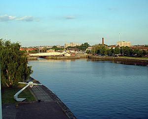
The basin looking eastwards
|
|
| Country | England |
| City | Bristol |
| District | Hotwells |
| Established | 1804-9 |
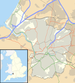
The Cumberland Basin is the main entrance to the docks in Bristol, England. It separates the areas of Hotwells from the tip of Spike Island. Think of it as a big gateway for ships entering and leaving Bristol's port.

History of the Basin
Before the 1800s, the River Avon used to flow right through the area that is now the Cumberland Basin. It was a tidal river, meaning its water level changed a lot with the tides. This made it hard for ships to dock safely.
To fix this, in 1802, a smart engineer named William Jessop suggested a big plan. He wanted to build a dam and a lock system at Hotwells. This would create a "Floating Harbour" where the water level would always stay the same, no matter the tide. This was a huge project, costing about £530,000 at the time!
Work began in May 1804. The plan included building the Cumberland Basin itself. This is a wide part of the harbour where the old stone walls and bollards (posts for tying up ships) are still standing today.
The new system needed a way for ships to move between the tidal river and the calm Floating Harbour. So, Jessop designed the Cumberland Basin with two entrance locks from the tidal Avon. These locks were like giant water elevators for ships. There was also a third lock connecting the Basin to the Floating Harbour. This clever setup allowed many ships to come and go smoothly. The new harbour officially opened on May 1, 1809.
Later, in 1831, eight houses were built for the Bristol Docks Company. In 1870, a special building called a hydraulic pump house was added. It used water pressure to power the bridges and other machines. Today, this building is a pub! The power for the bridges now comes from another hydraulic engine house at the Underfall Yard.
Brunel's Swing Bridges
When Isambard Kingdom Brunel, a famous engineer, rebuilt the entrance locks of the Cumberland Basin between 1848 and 1849, he also designed some amazing swinging bridges. These were his first bridges that could move!
These bridges were special because they spun around a central point. One side of the bridge was much longer than the other. To keep them balanced, Brunel used heavy cast iron weights.
The bridges were made for light roads, not heavy trains. So, Brunel used a clever, lightweight design for their main beams. This made them easier to build.
One of these bridges was moved in 1873. It was first moved by hand, then later by water power. In the 1960s, a new, bigger bridge called the Plimsoll Swing Bridge replaced it. Brunel's old bridge was left on the side and is now known as "Brunel's other bridge." It's famous because it's close to his more well-known Clifton Suspension Bridge.
The old Junction Lock swing bridge used to be powered by water pressure from the Underfall Yard. This was at a very high pressure of 750 pounds per square inch. In 2010, it was updated to use an electro-hydraulic system. The newer Plimsoll Bridge, finished in 1965, also uses a similar system, but with even higher oil pressure.
For a long time, Brunel's work on these bridges was almost forgotten. They were even in danger of being torn down! But then, people realized how important they were historically. "Brunel's other bridge" is now on a list of heritage sites that need help. In 2014, people started raising money to restore it. In 2019, Historic England gave a grant of £62,000 for the restoration work.
- Prince's Wharf, including M Shed, Pyronaut and Mayflower adjoining Prince Street Bridge
- Dry docks: SS Great Britain, the Matthew
- St Augustine's Reach, Pero's Bridge
- Bathurst Basin
- Queen Square
- Bristol Temple Meads railway station
- Castle Park
- Redcliffe Quay and Redcliffe Caves
- Baltic Wharf marina
- Cumberland Basin & Brunel Locks
- The New Cut
- Netham Lock, entrance to the Feeder Canal
- Totterdown Basin
- Temple Quay
- The Centre
- Canons Marsh, including Millennium Square and At-Bristol
- Underfall Yard
- Bristol Bridge
Future Plans for Western Harbour
The elevated roads around the Cumberland Basin were built in the 1960s. They are getting old and will soon need major repairs or replacement.
Since 2015, there have been plans to update this whole area. In 2017, Bristol's mayor, Marvin Rees, announced a plan to redevelop the area. It's now called Western Harbour. This name refers to the western entrance to the historic Floating Harbour, including the areas just north and south of it.
In August 2019, the city started asking local people for their ideas about the future of the area. They discussed new bridges and places to live. In 2021, Bristol City Council announced a six-month period to gather more community ideas. The goal is to create a vision for how this important part of Bristol will look in the future.
 | Janet Taylor Pickett |
 | Synthia Saint James |
 | Howardena Pindell |
 | Faith Ringgold |


