
Nagorno-Karabakh Republic facts for kids

The Nagorno-Karabakh Republic (NKR) or Artsakh Republic was a self-declared country in the South Caucasus. Its land was internationally recognized as part of Azerbaijan. From 1991 to 2023, Artsakh controlled parts of the area known as the Nagorno-Karabakh Autonomous Oblast. Its capital city was Stepanakert.
Artsakh was like an island of land surrounded by Azerbaijan. Its only road connecting it to Armenia was the Lachin corridor, which was about 5 kilometers (3.1 miles) wide. Most people living in Nagorno-Karabakh were Armenians. This region became a point of disagreement between Armenia and Azerbaijan in 1918.
After the Soviet Union took control, in 1923, they created the Nagorno-Karabakh Autonomous Oblast (NKAO) within the Azerbaijan Soviet Socialist Republic. As the Soviet Union was ending, the region became a source of conflict again. This led to the First Nagorno-Karabakh War from 1988 to 1994.
On December 10 1991, the NKAO and a nearby region held a vote. They decided to declare independence from Azerbaijan, calling themselves the Nagorno-Karabakh Republic. However, no other country or international organization officially recognized Artsakh as an independent state, not even Armenia.
Small conflicts happened in the area from time to time. A major one was the Second Nagorno-Karabakh War in 2020. In December 2022, Azerbaijan blocked the Lachin corridor, which was Artsakh's link to Armenia. After another attack by Azerbaijan on September 19, 2023, Artsakh's government agreed to disarm. This caused most ethnic Armenians to leave the area and move to Armenia.
On September 28, 2023, the president of Artsakh signed a paper to close all of the republic's government offices by January 1, 2024. By October 1, 2023, almost everyone had left for Armenia. Artsakh officially ended on January 1, 2024, as planned.
Contents
Geography of Artsakh
Artsakh was a very mountainous country. Its average height was about 1,097 meters (3,600 feet) above sea level.
The largest body of water was the Sarsang Reservoir. The two main rivers were the Tartar and the Khachen.
More than 36% of the country was covered in forests. In the flatter, grassy areas called steppes, you would mostly find plants that grow in dry, semi-desert conditions. Higher up in the mountains, above the forests, there were subalpine zone and alpine tundra areas with different types of plants.
Government and Politics
The Republic of Artsakh was a presidential democracy. This means the people voted for a president to lead the country. It had a single law-making body called the National Assembly.
The President was both the leader of the country and the head of the government. The president was chosen by direct vote and could serve up to two five-year terms.
Languages Spoken
Armenian was the only official language in the Republic of Artsakh. It was the native language for over 99% of the people living there.
People of Artsakh
About 99.7% of the people in Artsakh were ethnic Armenian. The main language they spoke was Armenian. Most of the population was Christian, and many belonged to the Armenian Apostolic Church.
Tourism and Attractions
Before the 2020 war, Artsakh had started to develop tourism. Many visitors came from Armenia and the Armenian diaspora (Armenians living in other countries).
Some of the popular places to visit included:
- Gandzasar monastery, a very important monastery.
- Ghazanchetsots Cathedral of the Holy Savior (now under Azerbaijani control).
- Church of the Holy Mother of God "Kanach Zham" (now under Azerbaijani control).
- Amaras Monastery.
- Tsitsernavank Monastery (now under Azerbaijani control).
- St. Yeghishe Arakyal Monastery.
- Dadivank Monastery.
- Gtichavank monastery (now under Azerbaijani control).
- Bri Yeghtsi monastery.
- Yerits Mankants.
- Katarovank Monastery (now under Azerbaijani control).
Other interesting places were:
- Fort Mayraberd (from the 10th to 18th centuries) was a strong fort that protected against attacks from the east. It is located east of the capital city, Stepanakert.
- Govharagha Mosque (18th century), a mosque in the city of Shusha, which is now under Azerbaijani control.

The Janapar Trail was a marked path through the mountains, valleys, and villages of Artsakh. Along the way, hikers could see monasteries and old forts. After the Second Nagorno-Karabakh War, this trail is no longer safe for hiking. The trail was designed for day hikes, allowing tourists to stay in a different village each night. These paths have existed for hundreds of years, but they were specifically marked for hikers in recent times. The main Janapar trail, marked in 2007, went from the northwest region of Shahumian to the southern town of Hadrut, which is now under Azerbaijani control. Side trails led to other parts of Artsakh. Important sites along this hike included Dadivank Monastery, Gandzasar monastery, Shusha, the Karkar Canyon with its tall cliffs, Zontik Waterfall, and the old ruins of Hunot and Gtichavank monastery.
Images for kids
-
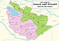
The lands of Syunik (left) and Artsakh (right) until the early ninth century
-
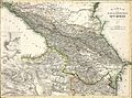
An 1856 German-language map labelling the region "Artssakh"
-
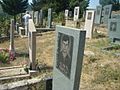
The graves of Armenian soldiers in Stepanakert.
-
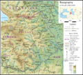
Topographic map of Artsakh in the borders 1994−2020
-
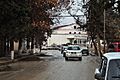
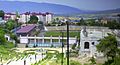
Martuni town
-
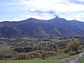
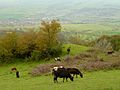
Mountain view in Martakert region
-

Children at Tumo Center Artsakh branch
-
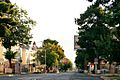
The Freedom Fighters' Boulevard in Stepanakert
-
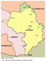
Main cities and towns in Artsakh (territorial control shown is prior to the 2020 war)
-
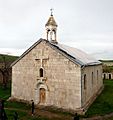
Church of St. Grigoris of the Amaras Monastery
-
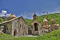
Dadivank Monastery
-
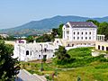
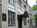
A hotel in downtown Stepanakert
-
Karmir Shuka.
-
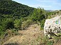
Section of Janapar trail.
-
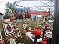
Exhibition of artworks at Artsakh Wine Fest
-
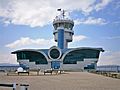
Stepanakert Airport
-
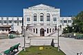
Artsakh State University
-
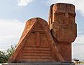
"We are our mountains" monument depicting a man and a woman
-
Artsakh State Museum
-
Stepanakert Republican Stadium in Stepanakert


.jpg)


.jpg)
.jpg)
.jpg)

See also
 In Spanish: Artsaj para niños
