Resolution Island (Nunavut) facts for kids

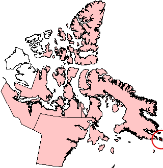
Resolution Island, Nunavut (red circle at edge of map).
|
|
| Geography | |
|---|---|
| Location | Davis Strait |
| Coordinates | 61°30′N 65°00′W / 61.500°N 65.000°W |
| Archipelago | Canadian Arctic Archipelago |
| Area | 1,015 km2 (392 sq mi) |
| Administration | |
| Territory | Nunavut |
| Region | Qikiqtaaluk |
| Demographics | |
| Population | Uninhabited |
| Ethnic groups | Inuit |
Resolution Island is a large, uninhabited island in Canada's Arctic. It is part of the many islands in the Canadian Arctic Archipelago. You can find it in the Qikiqtaaluk Region of Nunavut, a territory in northern Canada.
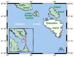
This island is located in the Davis Strait, which is a body of water between Baffin Island and Greenland. Resolution Island covers an area of about 1,015 square kilometers (392 square miles). The Lower Savage Islands are between Resolution Island and Baffin Island. Graves Strait separates Resolution Island from Edgell Island to the north.
Contents
Exploring Resolution Island's Past
Resolution Island has an interesting history. An English explorer named Martin Frobisher landed on the island on July 28, 1576. He was on a trip trying to find the famous Northwest Passage, a sea route through the Arctic.
The island got its name, Resolution, in 1612. It was named by Sir Thomas Button after his own ship, the Resolution.
A Former Military Base
Later, Resolution Island became home to an American military base. This base started operating in 1954. It was part of the Distant Early Warning Line (DEW line). The DEW line was a chain of radar stations built across the Arctic. Their purpose was to detect any incoming attacks during the Cold War.
The base on Resolution Island was closed in 1973. It was then handed over to the Canadian government in 1974. Today, it is known as CFS Resolution Island.
The MINNA Shipwreck
On August 18, 1974, a Canadian cargo ship called the "MINNA" was wrecked. This happened on the east side of Resolution Island. The ship was working for the Bedford Institute of Oceanography. It was doing scientific surveys when the accident occurred.
The "MINNA" was badly damaged. Its crew and scientific equipment were safely removed. Bad weather later pushed the ship into deeper waters. It sank on October 2, 1974. This vessel was 275 feet long and weighed 4,280 tons. It was based in Halifax and often helped with ocean surveys.
Cleaning Up the Island
During investigations between 1987 and 1990, pollution was found on the island. This pollution mostly came from spills from the old radar equipment. This equipment used chemicals called polychlorinated biphenyls (PCBs) as insulators.
Other harmful substances found included old transformer fluids, hydrocarbons (like oil), asbestos, and heavy metals. These were found in buildings and spread around the site. Resolution Island was found to have the highest level of PCB pollution among former military sites. These sites are managed by Crown–Indigenous Relations and Northern Affairs Canada.
In 1993 and 1994, a study of the island's environment was completed. As a result, temporary barriers were put in place. These barriers helped stop the PCBs from spreading into the water. More studies were done, and in 1997, cleanup work began.
This large-scale cleanup plan was created with help from Environment Canada, Qikiqtaaluk Corporation, and Queen's University. Steps were taken to make sure the pollutants were not harming people or wildlife.
See also
 In Spanish: Isla Resolución para niños
 | Stephanie Wilson |
 | Charles Bolden |
 | Ronald McNair |
 | Frederick D. Gregory |


